
www.taiwan-database.net
Maps 🗺
- Maps of the ROC provinces and municipalities (before 1949)
- Maps of the ROC's cities and counties
- Physical map of Taiwan
- Additional map index
Notes
Each map on this page can be displayed with a larger format by directly clicking on the image. In addition, the page Local administration of this website contains more detailed maps of every ROC special municipality, county and county-level city.
 Most of the maps used on
this website are sketches created by the chief researcher based on various
sources for practical information and orientation purposes only. The depiction of boundaries and related data shown
on these maps are not warranted to be error free as minor inaccuracies cannot be completely ruled out. Unless
otherwise indicated, all maps are oriented with North at the top. (A list of maps which were not created by the
chief researcher can be found here.)
Most of the maps used on
this website are sketches created by the chief researcher based on various
sources for practical information and orientation purposes only. The depiction of boundaries and related data shown
on these maps are not warranted to be error free as minor inaccuracies cannot be completely ruled out. Unless
otherwise indicated, all maps are oriented with North at the top. (A list of maps which were not created by the
chief researcher can be found here.)
EARTHQUAKES AND TYPHOONS—Maps used to illustrate the locations of epicenters and magnitude of earthquakes and to outline the paths of typhoons were provided by the Central Weather Administration (CWA) which was called "Central Weather Bureau" (CWB) before September 2023. Please note that this website offers two lists of earthquakes in the Taiwan area: those which occurred during during the Japanese colonial period (1895-1945), and temblors since WWII. All listed quakes since 1935 include a brief report created by the CWA with a map showing the quake's epicenter, CWA reports created 1995 or later also present the local largest intensity on the respective map.
===== ===== ===== ===== =====
◆ Maps of the ROC provinces and municipalities (before 1949)
++++++++++ TOP HOME [next chapter] ++++++++++
 Traditionally, China has been subdivided into six geographic
areas—Central China (huazhong diqu 華中地區), South China (huanan diqu 華南地區), North China (huabei
diqu 華北地區), Western China (xibu diqu 西部地區), Northeast China (dongbei diqu 東北地區), and
the Northern Frontier (saibei diqu 塞北地區).
Traditionally, China has been subdivided into six geographic
areas—Central China (huazhong diqu 華中地區), South China (huanan diqu 華南地區), North China (huabei
diqu 華北地區), Western China (xibu diqu 西部地區), Northeast China (dongbei diqu 東北地區), and
the Northern Frontier (saibei diqu 塞北地區).
The distribution of the ROC's provinces plus Mongolia, Taiwan and Tibet in these areas was as follows:
- Central China—7 provinces: Anhwei (Anhui sheng 安徽省), Chekiang (Zhejiang sheng 浙江省), Hunan (Hunan sheng 湖南省), Hupeh (Hubei sheng 湖北省), Kiangsi (Jiangxi sheng 江西省), Kiangsu (Jiangsu sheng 江蘇省), and Szechwan (Sichuan sheng 四川省);
- South China—5 provinces: Fukien (Fujian sheng 福建省), Kwangsi (Guangxi sheng 廣西省), Kwangtung (Guangdong sheng 廣東省), Kweichow (Guizhou sheng 貴州省), and Yunnan (Yunnan sheng 雲南省); plus Taiwan (Taiwan sheng 台灣省);
- North China—6 provinces: Honan (Henan sheng 河南省), Hopeh (Hebei sheng 河北省), Kansu (Gansu sheng 甘肅省), Shansi (Shanxi sheng 山西省), Shantung (Shandong sheng 山東省), and Shensi (Shanxi sheng 陝西省—spelled "Shaanxi" in today's China);
- Western China—3 provinces: Sikang (Xikang sheng 西康省), Sinkiang (Xinjiang sheng 新疆省), and Tsinghai (Qinghai sheng 青海省); plus Tibet (Xizang diqu 西藏地方);
- Northeast China—9 provinces: Antung (Andong sheng 安東省), Heilungkiang (Heilongjiang sheng 黑龍江省), Hokiang (Hejiang sheng 合江省), Hsing'an (Xing'an sheng 興安省), Kirin (Jilin sheng 吉林省), Liaoning (Liaoning sheng 遼寧省), Liaopeh (Liaobei sheng 遼北省), Nunkiang (Nenjiang sheng 嫩江省), and Sungkiang (Songjiang sheng 松江省);
- Northern Frontier—4 provinces: Chahar (Chahaer sheng 察哈爾省), Jehol (Rehe sheng 熱河省) Ninghsia (Ningxia sheng 寧夏省), and Suiyuan (Suiyuan sheng 綏遠省); plus Mongolia (Menggu 蒙古).
In addition, there were the following 12 municipalities (yuanxiashi 院轄市) in the ROC: Canton (Guangzhou shi 廣州市), Chungking (Chongqing shi 重慶市), Dairen (Dalian shi 大連市), Hankow (Hankou shi 漢口市), Harbin (Haerbin shi 哈爾濱市), Mukden (Shenyang shi 瀋陽市), Nanking (Nanjing shi 南京市), Peiping/Peking (Beiping shi 北平市), Shanghai (Shanghai shi 上海市), Sian (Xi'an shi 西安市), Tientsin (Tianjin shi 天津市), and Tsingtao (Qingdao shi 青島市).
The following map shows the distribution of provinces and municipalities in the ROC before 1949. Please note that before the end of WWII in 1945, Taiwan was not part of the ROC. (The question whether Taiwan's inclusion in the ROC was legitimate is analyzed—but not answered—here.)
ROC provinces: 1–Anhwei, 2–Antung, 3–Chahar, 4–Chekiang, 5–Fukien, 6–Heilungkiang, 7–Hokiang, 8–Honan, 9–Hopeh, 10–Hsing'an, 11–Hunan, 12–Hupeh, 13–Jehol, 14–Kansu, 15–Kiangsi, 16–Kiangsu, 17–Kirin, 18–Kwangsi, 19–Kwangtung, 20–Kweichow, 21–Liaoning, 22–Liaopeh, 23–Ninghsia, 24–Nunkiang, 25–Shansi, 26–Shantung, 27–Shensi, 28–Sikang, 29–Sinkiang, 30–Suiyuan, 31–Sungkiang, 32–Szechwan, 33–Tsinghai, and 34–Yunnan.
ROC municipalities: 1–Canton, 2–Chungking, 3–Dairen, 4–Hankow, 5–Harbin, 6–Mukden, 7–Nanking, 8–Peiping, 9–Shanghai, 10–Sian, 11–Tientsin, and 12–Tsingtao.

Map of the People's Republic of China (PRC)
 For comparison, the administrative division of the PRC is presented here; click on the map on the right
for an enlarged image.
For comparison, the administrative division of the PRC is presented here; click on the map on the right
for an enlarged image.
The People's Republic of China (Zhonghua renmin gongheguo 中華人民共和國) was founded on Oct. 1, 1949, and today it is subdivided into 22 provinces (sheng 省), 5 autonomous regions (zizhiqu 自治區, abbrev. AR), 4 special municipalities (zhixiashi 直轄市), and 2 special administrative regions (tebie xingzhengqu 特別行政區, abbrev. SAR). The capital of the PRC is Beijing. The numbers on the enlarged map correspond with the administrative entities as listed directly below.
1: Anhui 安徽, 2: Beijing 北京, 3: Chongqing 重慶, 4: Fujian 福建, 5: Gansu 甘肅, 6: Guangdong 廣東, 7: Guangxi 廣西, 8: Guizhou 貴州, 9: Hainan 海南, 10: Hebei 河北, 11: Heilongjiang 黑龍江, 12: Henan 河南, 13: Hong Kong [Xianggang] 香港, 14: Hubei 湖北, 15: Hunan 湖南, 16: Inner Mongolia [Nei Menggu] 內蒙古, 17: Jiangsu 江蘇, 18: Jiangxi 江西, 19: Jilin 吉林, 20: Liaoning 遼寧, 21: Macau [Aomen] 澳門, 22: Ningxia 寧夏, 23: Qinghai 青海, 24: Shaanxi 陜西, 25: Shandong 山東, 26: Shanghai 上海, 27: Shanxi 山西, 28: Sichuan 四川, 29: Tianjin 天津, 30: Tibet [Xizang] 西藏, 31: Xinjiang 新疆, 32: Yunnan 雲南, and 33: Zhejiang 浙江.
★ The 5 ARs are Guangxi, Inner Mongolia, Ningxia, Tibet, and Xinjiang.
★ The 4 special municipalities are Beijing, Chongqing, Shanghai, and Tianjin.
★ The 2 SARs are Hong Kong and Macau.
More about Taiwan's relations with the PRC can be found here.
===== ===== ===== ===== =====
◆ Maps of the ROC's cities and counties
++++++++++ TOP HOME [next chapter] [previous chapter] ++++++++++
Taiwan Province after WWII
 Taiwan was incorporated into the ROC in October 1945 following the surrender of the Japanese. At that time the administrative
subdivisions of Taiwan Province included 9 cities—Taipei {1},
Keelung {2}, Hsinchu {3}, Taichung {4},
Changhua {5}, Chiayi {6}, Tainan {7},
Kaohsiung {8}, Pingtung {9}; and 8 counties—Taipei
{A}, Hsinchu {B}, Taichung {C},
Tainan {D}, Kaohsiung {E}, Hualien {F},
Taitung {G}, Penghu {H}; the territorial layout of the 8 counties being
almost identical with the 8 prefectures under Japanese rule.
Taiwan was incorporated into the ROC in October 1945 following the surrender of the Japanese. At that time the administrative
subdivisions of Taiwan Province included 9 cities—Taipei {1},
Keelung {2}, Hsinchu {3}, Taichung {4},
Changhua {5}, Chiayi {6}, Tainan {7},
Kaohsiung {8}, Pingtung {9}; and 8 counties—Taipei
{A}, Hsinchu {B}, Taichung {C},
Tainan {D}, Kaohsiung {E}, Hualien {F},
Taitung {G}, Penghu {H}; the territorial layout of the 8 counties being
almost identical with the 8 prefectures under Japanese rule.
On Aug. 26, 1949 the Tsaoshan Administrative Bureau (caoshan guanliju 草山管理局) {X} was established, comprising the Townships of Shihlin 士林鎮 and Peitou 北投鎮. The bureau was renamed Yangmingshan Administrative Bureau (Yangmingshan guanliju 陽明山管理局) on March 31, 1950.
In August 1950 the administrative subdivision of Taiwan Province was reorganized to 5 cities (Taipei, Keelung, Taichung, Tainan, Kaohsiung), 16 counties (Taipei, Taoyuan, Hsinchu, Miaoli, Taichung, Changhua, Nantou, Yunlin, Chiayi, Tainan, Kaohsiung, Pingtung, Yilan, Hualien, Taitung, Penghu) plus the Yangmingshan Administrative Bureau. When the latter was abolished on Jan. 1, 1974, the townships of Peitou and Shihlin became districts of Taipei City. Taipei City was upgraded to the status of special municipality on July 1, 1967, Kaohsiung City was upgraded to special municipality on July 1, 1979. On July 1, 1982, two cities were added to the administrative structure when the counties of Hsinchu and Chiayi were split into Hsinchu City / Hsinchu County and Chiayi City / Chiayi County, respectively. Details about the current subdivisions in the local administration of Taiwan/the ROC with numerous maps can be found here.
 The map on the right shows Taiwan proper and the ROC's three offshore counties in the Taiwan Strait. In this context it has to be pointed out that Kinmen County and Lienchiang County
do not belong to Taiwan Province but are under the jurisdiction of
the ROC's Fujian Province.
The map on the right shows Taiwan proper and the ROC's three offshore counties in the Taiwan Strait. In this context it has to be pointed out that Kinmen County and Lienchiang County
do not belong to Taiwan Province but are under the jurisdiction of
the ROC's Fujian Province.
Notes
- Status and area of the ROC's three offshore counties (Penghu, Kinmen and Lienchiang/Matsu) have remained unchanged since 1950.
- The geographical features of the smaller islands in the Taiwan area are presented here.
TOP HOME [◆ Cities and counties]
————————————————————
Taiwan proper between 1974 and 2014
The following four maps illustrate the development of administrative subdivisions on Taiwan between Jan. 1, 1974 and Dec. 24, 2014 (click on the maps to enlarge).
- Taiwan proper (Jan. 1, 1974 to June 30, 1979)
- Taiwan proper (July 1, 1979 to June 30, 1982)
- Taiwan proper (July 1, 1982 to Dec. 24, 2010)
- Taiwan proper (Dec. 25, 2010 to Dec. 24, 2014)
(Jan. 1, 1974 to June 30, 1979)  |
(July 1, 1979 to June 30, 1982)  Kaohsiung City was upgraded to special municipality on July 1, 1979. |
TOP HOME [◆ Maps of Taiwan's cities and counties]
————————————————————
(July 1, 1982 to Dec. 24, 2010)  Hsinchu City and Chiayi City were upgraded to separate county-level cities on July 1, 1982. |
(Dec. 25, 2010 to Dec. 24, 2014)  On Dec. 25, 2010 Taipei County was upgraded to special municipality and renamed New Taipei City, Kaohsiung County was absorbed by Kaohsiung City, Taichung City absorbed Taichung County and was upgraded to special municipality, and likewise Tainan City absorbed Tainan County and was upgraded to special municipality. |
TOP HOME [◆ Maps of Taiwan's cities and counties]
————————————————————
Taiwan proper (since Dec. 25, 2014)
Taoyuan County was upgraded to special municipality and renamed Taoyuan City on Dec. 25, 2014.
Click here for more details about the current subdivisions in the local administration of Taiwan/the ROC.

(Not on this map: the three offshore counties outside Taiwan proper—
Penghu
County; Kinmen County, Lienchiang County.)
All maps Copyright © 2009-2026 Tilman Aretz
TOP HOME [◆ Maps of Taiwan's cities and counties]
===== ===== ===== ===== =====
◆ Physical map of Taiwan
++++++++++ TOP HOME [next chapter] [previous chapter] ++++++++++
Copyright notice for the three maps below:
© Relief Maps, computed by Hans Braxmeier. Courtesy maps-for-free.com
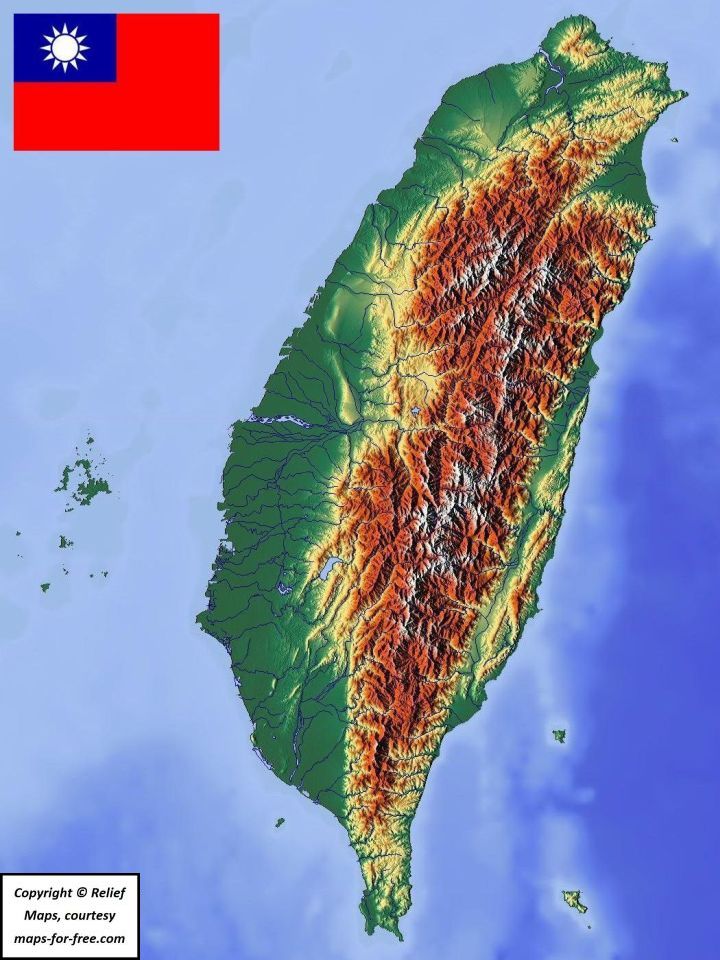
As an interesting supplement, the user can click here to view a map which shows the next subdivisions below the county/county-level city/special municipality category in Taiwan, i. e. districts; cities, urban townships and rural townships. Geographically larger subdivisions in most cases indicate sparsely populated hilly terrain, small subdivisions are often a sign for very high population density.
The two maps below show Kinmen on the left and Matsu on the right.


More maps from the same source are the following:
- For a physical map of Penghu click here.
- A composite image comprising physical maps of Lanyu aka Orchid Island (top left), Ludao/Lyudao aka Green Island (top right), Siaoliouciou/Liuchiu (bottom left) and Guishan Island aka Turtle Island (bottom right) can be found here.
- The Taiwan area—click here.
- Northern Taiwan—click here.
- Taiwan's northern tip—click here.
- Central Taiwan—click here.
- Southern Taiwan—click here.
- Taiwan's southern tip—click here.
(Copyright © Relief Maps, computed by Hans Braxmeier; courtesy maps-for-free.com)
===== ===== ===== ===== =====
◆ Additional map index
++++++++++ TOP HOME [previous chapter] ++++++++++
The following lists contain 136 maps which can be found on other pages of this website, including Introduction Taiwan / ROC, Other central government agencies, Local administration, and Tools. Unless otherwise indicated, those maps were created by the website's chief researcher. Detailed copyright notices for the 10 maps not created by the chief researcher can be found here.
- General geographic maps
- Maps of smaller islands
- Historical maps of Taiwan
- Maps concerning Taiwan’s indigenous peoples
- Thumbnail administrative maps
- Detailed administrative maps
- Other maps
General geographic maps
A general introduction about Taiwan and the ROC's jurisdiction can be found here.
| Taiwan’s position in East Asia | Taiwan off China’s southeast coast | |
| Taiwan proper, offshore counties | Tai Peng Jin Ma I | Tai Peng Jin Ma II |
| The Taiwan area | All 22 ROC cities, counties | South China Sea (Copy- right © Creative Commons, author: Goran tek-en—Jan. 23, 2014) |
| Taiwan Province | Okinawa Trough (Copy- right © maps-for-free.com) |
|
| Fujian Province (ROC) | ||
| ROC before 1945 | Constellation in the East China Sea (Diaoyutai Islands) | |
| Taiwan’s river system | Taiwan’s faults—English (Copyright © CGS) |
Taiwan’s faults—Chinese (Copyright © CGS) |
| PRC: small map | PRC: administrative subdivisions | |
TOP HOME [◆ Additional maps index]
Maps of smaller islands
The geographical features of smaller islands belonging to Taiwan/the ROC are explained here.
TOP HOME [◆ Additional maps index]
Historical maps of Taiwan
The history of Taiwan is explained here.
TOP HOME [◆ Additional maps index]
Maps concerning Taiwan’s indigenous peoples
Details about Taiwan's indigenous peoples can be found here.
| Indigenous languages before colonization (Copyright Wikimedia © Creative Commons, author: Kwamikagami, at English Wikipedia, date: Aug. 28, 2008) |
Distribution of 16 indigenous tribes (Copyright © ROC Yearbook 2015) |
Distribution of 16 indigenous tribes (Copyright © National Chiayi University) |
|
| Distribution of 9 indigenous tribes (Copyright © ROC Yearbook 2000) |
55 indigenous communities (all Taiwan proper) | ||
| ... New Taipei City | ... Taoyuan City | ... Hsinchu County | ... Miaoli County |
| ... Taichung City | ... Nantou County | ... Chiayi County | ... Kaohsiung City |
| ... Pingtung County | ... Yilan County | ... Hualien County | ... Taitung County |
TOP HOME [◆ Additional maps index]
Thumbnail administrative maps
The thumbnail maps show the location of the respective city/county on Taiwan proper or—for the three offshore counties Penghu, Kinmen and Lienchiang/Matsu—in the Taiwan area. The page Local administration provides information about all special municipalities, counties and county-level cities in the ROC.
Special municipalities
| Taipei | Kaohsiung | New Taipei City |
| Taoyuan | Taichung | Tainan |
Counties
| Hsinchu County | Miaoli | Changhua | |
| Nantou | Yunlin | Chiayi County | |
| Pingtung | Yilan | Hualien | Taitung |
| Penghu | Kinmen | Lienchiang County | |
County-level cities
| Keelung | Hsinchu City | Chiayi City |
TOP HOME [◆ Additional maps index]
Detailed administrative maps
Special municipalities
Counties
County-level cities
| Keelung City subdivisions | Hsinchu City subdivisions | Chiayi City subdivisions |
TOP HOME [◆ Additional maps index]
Other maps
TOP HOME [◆ Additional maps index]
===== ===== ===== ===== =====
↻ This page was last updated/edited on March 31, 2026.
 |
 |