
www.taiwan-database.net
Local administration
- The special municipalities, counties and cities of the ROC
- The system of local administration in the ROC
- The ROC's 22 local administration units
- Data about the ROC cities and counties
- Restructuring of special municipalities, counties and cities
- Further administrative subdivisions at all levels
- The provincial level of the ROC
- Special municipalities in the ROC
- Counties in the ROC
- County-level cities in the ROC
- Abolished local governments
===== ===== ===== ===== =====
◆ The special municipalities, counties and cities of the ROC
- The system of local administration in the ROC
- The ROC's 22 local administration units
- Data about the ROC cities and counties
- Restructuring of special municipalities, counties and cities
- Further administrative subdivisions at all levels
This page explains the system of local administration in the ROC and lists their major units. Furthermore, it shows local government leaders from 1989 on (except Taiwan Province, Fujian Province, Taipei City, and Kaohsiung City—data going back to 1945) because only after martial law was lifted in the ROC in July 1987 elections could be regarded as truly free and democratic. In addition to the respective city mayors and county magistrates the administrative division of each special municipality, county and provincial municipality is listed as well. Details about boroughs, villages and neighbourhoods are omitted here since they are far too numerous (nationwide elections for borough wardens and village chiefs as in 2014 and 2018 filled 7,851 positions) and not significant enough to be listed individually in this website.
An alphabetical index on this page lists all cities, districts, rural townships and urban townships of the ROC (click here). The three-digit number added behind an administrative subdivision is its postal code. Further information about the geographical features of Penghu, Kinmen, Matsu and other smaller islands under ROC jurisdiction can be found here.
++++++++++ TOP HOME [next chapter] ++++++++++
The system of local administration in the ROC
Below the central level, the ROC today comprises two provinces (sheng 省)—Taiwan 台灣 and Fujian 福建—plus 6 special municipalities (zhixiashi 直轄市) directly under the jurisdiction of the central government. It should be noted that in practical administrative reality, the two provincial governments were streamlined since 1998, and by the end of 2018 the positions of provincial governors were abolished—in other words, Taiwan Province and Fujian Province only exist as terms for geographical orientation but no longer as working administrative entities. Nevertheless, counties (xian 縣) and county-level cities (shengxiashi 省轄市) aka provincial municipalities are nominally still listed under the provinces; Taiwan Province has 14 county-level local governments, Fujian Province has 2.
The following diagram presents the ROC's overall system of local administration in a nutshell. Subdivisions on lower levels under the special municipalities, counties and county-level cities are explained further below.
直轄市 |
|||
| County-level cities 省轄市 | |||
| [6 special municipalities] | [11 counties] | [3 county-level cities] | [2 counties] |
Historically, the system of provinces and special municipalities as administrative subdivisions below the central level dates back to the time when the Chinese mainland was still under ROC government control, before Taiwan was even part of the ROC. For more details click here.
TOP HOME [◆ Introduction] [Local administration system]
The ROC's 22 local administration units
- Overview
- Geographical distribution
- Unofficial divisions: seven regions, four zones
- No uniform definition for "central Taiwan"
- Additional remarks for this page
Overview
Local administration in the ROC consists of 22 units—6 special municipalities, 3 county-level cities (which are sometimes also called "provincial municipalities"), and 13 counties.
- While all six special municipalities of the ROC are geographically located on the territory of Taiwan proper, they are not under the jurisdiction of Taiwan Province but under the direct administration of the central government.
- Of the 13 counties, 11 belong to Taiwan Province, 2 belong to Fujian Province.
- All three county-level cities are located on Taiwan proper and under the jurisdiction of Taiwan Province (see table directly below).
| 6 special municipalities | 10 counties on Taiwan proper | 3 offshore counties | 3 county-level cities |
|---|---|---|---|
| Taipei City Kaohsiung City New Taipei City Taoyuan City Taichung City Tainan City (all ROC special mu- nicipalities located on Taiwan proper) |
Hsinchu County Miaoli County Changhua County Nantou County Yunlin County Chiayi County Pingtung County Yilan County Hualien County Taitung County (all under Taiwan province) |
Penghu County (Taiwan province) Kinmen County Lienchiang County (both under Fu- jian Province) |
Keelung City Hsinchu City Chiayi City (formally under Taiwan Province) |
| [Disambiguation: Cities] |
 A list of the relevant administrative terms in Chinese can be found here.
The map directly on the right shows the position of the ROC in East Asia (click to enlarge).
The following two maps illustrate the location of the ROC's cities and counties (click on them to enlarge); in the map below right, Taiwan proper and the three offshore counties are not presented with a uniform scale.
 |
 |
Please note that Kinmen County and Lienchiang County (Matsu) under Fujian Province are the only administrative areas which have been continuously under ROC control since 1912, the cities and counties of Taiwan Province were added to the ROC after the end of WWII. A helpful visual tool for a better understanding of the ROC's administrative subdivisions and their development since 1945 can be found here.
TOP HOME [◆ Introduction] [Overview ROC cities / counties]
Geographical distribution
The following tables include links leading to maps of the ROC's 22 local administration units, showing the location of the respective unit within the ROC.
| 6 special municipalities | 3 county-level cities | |
|---|---|---|
| Taipei City (Taibei shi 台北市) | Keelung City (Jilong shi 基隆市) | |
| New Taipei City (Xinbei shi 新北市) | Hsinchu City (Xinzhu shi 新竹市) | |
| Taoyuan City (Taoyuan shi 桃園市) | Chiayi City (Jiayi shi 嘉義市) | |
| Taichung City (Taizhong shi 台中市) | ||
| Tainan City (Tainan shi 台南市) | ||
| Kaohsiung City (Gaoxiong shi 高雄市) | ||
| Taiwan Province (11 counties) | Fujian Province (2 counties) | |
|---|---|---|
| Hsinchu County (Xinzhu xian 新竹縣) | Kinmen County (Jinmen xian 金門縣) | |
| Miaoli County (Miaoli xian 苗栗縣) | Lienchiang County (Lianjiang xian 連江縣) | |
| Changhua County (Zhanghua xian 彰化縣) | ||
| Nantou County (Nantou xian 南投縣) | ||
| Yunlin County (Yunlin xian 雲林縣) | ||
| Chiayi County (Jiayi xian 嘉義縣) | ||
| Pingtung County (Pingdong xian 屏東縣) | ||
| Yilan County (Yilan xian 宜蘭縣) | ||
| Hualien County (Hualian xian 花蓮縣) | ||
| Taitung County (Taidong xian 台東縣) | ||
| Penghu County (Penghu xian 澎湖縣) | ||
Penghu County, Kinmen County and Lienchiang County are offshore counties (i. e. separate islands, not on Taiwan proper); Lienchiang County is the administrative name for the Matsu Islands (Mazu 馬祖).
TOP HOME [◆ Introduction] [Overview ROC cities / counties]
Unofficial divisions: seven regions, four zones
While the administrative subdivisions of cities and counties as shown above are widely used in Taiwan's media to identify locations in news coverage, other classifications do exist. A distinction that is quite common in this context is the one between Taiwan proper (Taiwan bendao 台灣本島) and Taiwan's outlying islands or offshore islands (Taiwan lidao 台灣離島 or waidao 外島). Furthermore, some local TV channels combine cities and counties for their weather forecasts, often showing seven regions as listed below.
- Greater Taipei (beibeiji 北北基): Taipei, New Taipei City, Keelung;
- Taoyuan, Hsinchu, Miaoli (taozhumiao 桃竹苗): Taoyuan, Hsinchu City, Hsinchu County, Miaoli;
- Greater Taichung (zhongzhangtou 中彰投): Taichung, Changhua, Nantou;
- Greater Tainan (yunjia'nan 雲嘉南): Yunlin, Chiayi City, Chiayi County, Tainan;
- Kaoping (gaoping 高屏): Kaohsiung and Pingtung;
- East Coast (yihuadong 宜花東): Yilan, Hualien, Taitung;
- Outlying Islands (pengjinma 澎金馬): Penghu, Kinmen, Matsu/Lienchiang County.


| Region |
Area | Population (end of 2025) | Ø | ||
|---|---|---|---|---|---|
| Square km | Percentage | Persons | Percentage | ||
| ① | 2,457.1253 | 6.788 % | 6,844,174 | 29.375 % | 2,785 |
| ② | 4,572.9584 | 12.634 % | 3,939,253 | 16.907 % | 861 |
| ③ | 7,395.7288 | 20.433 % | 4,546,552 | 19.513 % | 614 |
| ④ | 5,446.148 | 15.046 % | 3,238,239 | 13.898 % | 594 |
| ⑤ | 5,727.7229 | 15.824 % | 3,500,801 | 15.025 % | 611 |
| ⑥ | 10,287.4491 | 28.422 % | 970,463 | 4.165 % | 94 |
| ⑦ | 307.3201 | 0.849 % | 259,650 | 1.114 % | 844 |
| ROC total | 36,194.4526 | 100.00 % | 23,299,132 | 100.00 % | 643 |
Please note that the column on the far right shows the region's population density in persons per square kilometer.
Another subdivision is applied during the Wanan air defense exercise (wan'an yanxi 萬安演習) which is held annually nationwide in four zones (diqu 地區).
- Northern Taiwan (beibu diqu 北部地區)—Taipei, New Taipei City, Keelung, Taoyuan, Hsinchu county and city, and Yilan County
- Central Taiwan (zhongbu diqu 中部地區)—Taichung, Chiayi county and city, and Miaoli, Changhua, Nantou and Yunlin counties
- Southern Taiwan (nanbu diqu 南部地區)—Tainan, Kaohsiung and Pingtung County
- Eastern Taiwan and outlying areas (dongbu diqu ji wailidao 東部地區及外離島)—Hualien, Taitung; Penghu, Kinmen and Lienchiang counties

TOP HOME [◆ Introduction] [Overview ROC cities / counties]
No uniform definition for "central Taiwan"
The terms "north Taiwan", "south Taiwan", "east Taiwan", and "central Taiwan" are often used to clarify a location on the island. It should be noted that not only "west Taiwan" is hardly ever used, there is also no consensus on the exact demarcation of central Taiwan.
 The following classification is by and large not controversial.
- North Taiwan: Taipei City, Keelung City, New Taipei City, Taoyuan City, Hsinchu City, Hsinchu County
- Central Taiwan: Taichung City, Changhua County, Nantou County, Yunlin County
- South Taiwan: Tainan City, Kaohsiung City, Pingtung County
- East Taiwan: Yilan County, Hualien County, Taitung County
As for the counties in eastern Taiwan, Yilan County is often referred to as northeast Taiwan, Hualien County as eastern Taiwan, and Taitung County as southeast Taiwan.
For the following cities and counties, their geographical description may vary.
- Miaoli County is sometimes classified as north Taiwan or as central Taiwan.
- Chiayi City and Chiayi County are sometimes classified as south Taiwan or as central Taiwan.
TOP HOME [◆ Introduction] [Overview ROC cities / counties]
Additional remarks for this page
Local level ballots
The dates of elections for mayors (shizhang 市長) of special municipalities, for city mayors (shizhang 市長)
and county magistrates (xianzhang 縣長) can be found under the page "Democratic
elections" of this website. In August 2009, the terms of mayors and county magistrates (sometimes also called "county
commissioner" in English) in the ROC to be elected on Dec. 5, 2009, were extended by a year to five years. Accordingly,
the Dec. 5 elections did not include Taipei County, Kaohsiung County, Taichung County, Taichung City, Tainan City and
Tainan County as they were either directly upgraded to the status of a special municipality or integrated into a special
municipality on Dec. 25, 2010. They held their elections simultaneously with heads of the two existing special
municipalities—Taipei City and Kaohsiung City—on Nov. 27, 2010.
Protected areas
The data about each city and county also include references about protected zones on their respective administrative areas
like the ROC's 9 national parks (guojia gongyuan 國家公園), 1 national nature park (guojia ziran gongyuan
國家自然公園), 22 nature reserves (ziran baohuqu 自然保留區), 20 wildlife refuges (yesheng dongwu baohuqu
野生動物保護區), 37 major wildlife habitats (yesheng dongwu zhongyao qixi huanjing 野生動物重要棲息環境), 6 forest
reserves (ziran baohuqu 自然保護區), and 12 coastal protection areas (yanhai baohuqu 沿海保護區).
Lack of certain data
Please note that for some names the information available (official English spelling of the name, birth year, and / or political
affiliation) was incomplete. In each case the chief researcher wrote to the respective
city / county government (Keelung City, Taichung City, Taoyuan County, Yunlin County, Hualien County, Taitung County, Penghu
County) but either received no response at all, or the agency was unable or unwilling to provide the requested information.
TOP HOME [◆ Introduction] [Overview ROC cities / counties]
Data about the ROC cities and counties
- Demographic development since 2010
- Area of ROC cities and counties (end of 2022)
- Geographic coordinates of the ROC's cities and counties
Source for the data in the following two tables is the Department of Household Registration Affairs 戶政司, MOI. For general ROC population statistics click here.
The column far right in the first table shows the respective population gains and losses between 2010 and 2022 as well as their percentage (2010 = 100 percent).
Demographic development since 2010
| City / county | 2010 | 2013 | 2016 | 2019 | 2022 | ± (%) |
|---|---|---|---|---|---|---|
| Taipei City | 2,618,772 | 2,686,516 | 2,695,704 | 2,645,041 | 2,480,681 | – 138,091 (– 5.273 %) |
| New Taipei City | 3,897,367 | 3,954,929 | 3,979,208 | 4,018,696 | 3,995,551 | + 98,184 (+ 2.519 %) |
| Taoyuan City | 2,002,060 | 2,044,023 | 2,147,763 | 2,249,037 | 2,281,464 | + 279,404 (+ 13.955 %) |
| Taichung City | 2,648,419 | 2,701,661 | 2,767,239 | 2,815,261 | 2,814,459 | + 166,040 (+ 6.269 %) |
| Tainan City | 1,873,794 | 1,883,208 | 1,886,033 | 1,880,906 | 1,852,997 | – 20,797 (– 1.109 %) |
| Kaohsiung City | 2,773,483 | 2,779,877 | 2,779,371 | 2,773,198 | 2,728,137 | – 45,346 (– 1.634 %) |
| Hsinchu County | 513,015 | 530,486 | 547,481 | 563,933 | 580,503 | + 67,488 (+ 13.155 %) |
| Miaoli County | 560,968 | 565,554 | 559,189 | 545,459 | 535,132 | – 25,836 (– 4.605 %) |
| Changhua County | 1,307,286 | 1,296,013 | 1,287,146 | 1,272,802 | 1,245,239 | – 62,047 (– 4.746 %) |
| Nantou County | 526,491 | 517,222 | 505,163 | 494,112 | 479,595 | – 46,896 (– 8.907 %) |
| Yunlin County | 717,653 | 707,792 | 694,873 | 681,306 | 664,092 | – 53,561 (– 7.463 %) |
| Chiayi County | 543,248 | 529,229 | 515,320 | 503,113 | 488,158 | – 55,090 (– 10.140 %) |
| Pingtung County | 873,509 | 852,286 | 835,792 | 819,184 | 798,703 | – 74,806 (– 8.563 %) |
| Yilan County | 460,486 | 458,456 | 457,538 | 454,178 | 449,062 | – 11,424 (– 2.480 %) |
| Hualien County | 338,805 | 333,897 | 330,911 | 326,247 | 318,892 | – 19,913 (– 5.877 %) |
| Taitung County | 230,673 | 224,821 | 220,802 | 216,781 | 212,551 | – 18,122 (– 7.856 %) |
| Penghu County | 96,918 | 100,400 | 103,263 | 105,207 | 107,223 | + 10,305 (+ 10.632 %) |
| Keelung City | 384,134 | 374,914 | 372,100 | 368,893 | 361,526 | – 22,608 (– 5.885 %) |
| Hsinchu City | 415,344 | 428,483 | 437,337 | 448,803 | 452,473 | + 37,129 (+ 8.939 %) |
| Chiayi City | 272,390 | 270,872 | 269,874 | 267,690 | 262,924 | – 9,466 (– 3.475 %) |
| Kinmen County | 97,364 | 120,713 | 135,114 | 140,185 | 141,295 | + 43,931 (+ 45.120 %) |
| Lienchiang County | 9,944 | 12,165 | 12,595 | 13,089 | 13,983 | + 4,039 (+ 40.617 %) |
| ROC total | 23,162,123 | 23,373,517 | 23,539,816 | 23,603,121 | 23,264,640 | + 102,517 (+ 0.442 %) |
The following table shows the population of the special municipalities, counties and cities at the end of 2025; total population of the ROC then 23,299,132 persons.
| City / county | Population | City / county | Population | |
|---|---|---|---|---|
| Taipei City | 2,439,507 | Chiayi County | 473,181 | |
| New Taipei City | 4,044,831 | Pingtung County | 782,256 | |
| Taoyuan City | 2,355,106 | Yilan County | 449,336 | |
| Taichung City | 2,868,465 | Hualien County | 312,807 | |
| Tainan City | 1,852,477 | Taitung County | 208,320 | |
| Kaohsiung City | 2,718,545 | Penghu County | 106,716 | |
| Hsinchu County | 597,235 | Keelung City | 359,836 | |
| Miaoli County | 531,172 | Hsinchu City | 455,740 | |
| Changhua County | 1,210,206 | Chiayi City | 261,592 | |
| Nantou County | 467,881 | Kinmen County | 139,313 | |
| Yunlin County | 650,989 | Lienchiang County | 13,621 |
TOP HOME [◆ Introduction] [Data ROC cities / counties]
Area of ROC cities and counties (end of 2025)
| City / county | Area (km2) | City / county | Area (km2) | |
|---|---|---|---|---|
| Taipei City | 271.7997 | Pingtung County | 2,775.6003 | |
| New Taipei City | 2,052.5667 | Yilan County | 2,143.6251 | |
| Taoyuan City | 1,220.9540 | Hualien County | 4,628.5714 | |
| Taichung City | 2,214.8968 | Taitung County | 3,515.2526 | |
| Tainan City | 2,191.6531 | Penghu County | 126.8641 | |
| Kaohsiung City | 2,952.1226 | Keelung City | 132.7589 | |
| Hsinchu County | 1,427.5369 | Hsinchu City | 104.1526 | |
| Miaoli County | 1,820.3149 | Chiayi City | 60.0256 | |
| Changhua County | 1,074.3960 | Kinmen County | 151.6560 | |
| Nantou County | 4,106.4360 | Lienchiang County | 28.8000 | |
| Yunlin County | 1,290.8326 | Pratas Islands | 2.3800 | |
| Chiayi County | 1,903.6367 | Spratly Islands | 0.5045 | |
| ROC total: 36,197.3371 km2 | ||||
The size of the Taiwan area with the three offshore counties Penghu, Kinmen, and Lienchiang included but the islands in the South China Sea excluded was 36,194.4526 km2. (Source: MOI statistics)
TOP HOME [◆ Introduction] [Data ROC cities / counties]
Geographic coordinates of the ROC's cities and counties
| City / county | Latitude | Longitude |
|---|---|---|
| Taipei City | 24° 34' 12"—25° 07' 12" N | 121° 16' 12"—121° 23' 24" E |
| New Taipei City | 24° 24' 00"—25° 10' 12" N | 121° 09' 36"—122° 00' 00" E |
| Taoyuan City | 24° 21' 00"—25° 04' 12" N | 120° 35' 24"—121° 16' 48" E |
| Taichung City | 23° 35' 24"—24° 15' 36" N | 120° 16' 48"—121° 16' 12" E |
| Tainan City | 22° 31' 48"—23° 14' 24" N | 120° 01' 12"—120° 23' 24" E |
| Kaohsiung City | 22° 16' 48"—23° 16' 48" N | 120° 06' 00"—121° 01' 12" E |
| Hsinchu County | 24° 15' 00"—24° 33' 36" N | 120° 33' 36"—121° 14' 24" E |
| Miaoli County | 24° 10' 12"—24° 26' 24" N | 120° 22' 12"—121° 09' 00" E |
| Changhua County | 23° 27' 36"—24° 06' 36" N | 120° 08' 24"—120° 24' 36" E |
| Nantou County | 23° 15' 36"—24° 08' 24" N | 120° 21' 36"—121° 12' 00" E |
| Yunlin County | 23° 18' 00"—23° 30' 30" N | 120° 04' 48"—120° 26' 24" E |
| Chiayi County | 23° 07' 12"—23° 22' 12" N | 120° 04' 12"—120° 34' 12" E |
| Pingtung County | 21° 31' 48"—22° 31' 12" N | 120° 12' 36"—120° 32' 24" E |
| Yilan County | 24° 10' 48"—24° 35' 24" N | 121° 11' 24"—121° 34' 48" E |
| Hualien County | 23° 03' 00"—24° 12' 36" N | 120° 35' 24"—121° 27' 36" E |
| Taitung County | 21° 33' 36"—23° 15' 36" N | 120° 26' 24"—121° 21' 00" E |
| Penghu County | 23° 06' 36"—23° 27' 00" N | 119° 11' 24"—119° 24' 36" E |
| Keelung City | 25° 01' 48"—25° 06' 00" N | 121° 22' 12"—121° 21' 48" E |
| Hsinchu City | 24° 25' 12"—24° 30' 36" N | 120° 31' 12"—121° 01' 12" E |
| Chiayi City | 23° 15' 36"—23° 18' 36" N | 120° 13' 48"—120° 18' 00" E |
| Kinmen County | 24° 13' 48"—24° 18' 36" N | 118° 07' 12"—118° 16' 48" E |
| Lienchiang County | 26° 04' 48"—26° 10' 12" N | 119° 32' 24"—120° 00' 00" E |
Please note that of the above listed special municipalities, cities and counties in the ROC, only Taipei City, Chiayi City and Nantou County are landlocked without their own direct access to the sea. The Port of Taipei (Taibei gang 台北港) is actually located in Bali District, New Taipei City.
TOP HOME [◆ Introduction] [Data ROC cities / counties]
Restructuring of special municipalities, counties and cities
- Emerging special municipalities
- Comparative charts of county-level administrative units in Taiwan Province
Emerging special municipalities
Taipei City was upgraded to special municipality on July 1, 1967, making it the first special municipality on the island. Kaohsiung City was declared a special municipality on July 1, 1979.
On June 29, 2009, the ROC government approved changes in the division of administrative districts, resulting in the upgrading and/or merger of several cities, counties and special municipalities in Taiwan proper. The following changes were implemented on Dec. 25, 2010:
- Inclusion of Kaohsiung County into Kaohsiung Special Municipality, nicknamed "Greater Kaohsiung" (da Gaoxiong 大高雄)
- Upgrading of Taipei County to a new special municipality, New Taipei City
- Merger of Taichung City and Taichung County to form a new special municipality: Taichung Special Municipality, nicknamed "Greater Taichung" (da Taizhong 大台中)
- Merger of Tainan City and Tainan County to form a new special municipality: Tainan Special Municipality, nicknamed "Greater Tainan" (da Tainan 大台南)
On Jan. 1, 2011 Taoyuan County was declared a "quasi-special municipality" by the ROC government after having reached a population of 2 million in June 2010. On Nov. 23, 2012 the ROC Ministry of the Interior approved Taoyuan County's application for administrative upgrade to special municipality, a decision confirmed by the Executive Yuan on Jan. 3, 2013. The status upgrade took effect on Dec. 25, 2014.
An important legal foundation for the upgrade to special municipality and for mergers of cities and counties is the Local Government Act (difang zhidufa 地方制度法), first announced on Jan. 25, 1999 and last amended on June 22, 2016. According to Article 4, a region with a population of 1.25 million and above that has "special needs for political, economic, cultural, and metropolitan developments" can be reconstituted as a special municipality.
TOP HOME [◆ Introduction] [Directory "Restructuring"]
Comparative charts of county-level administrative units in Taiwan Province
The following charts are about Taiwan Province only because the administrative status of the two counties in the ROC's Fujian Province—Kinmen County and Lienchiang County (Matsu)—has remained unchanged since 1950.
| Jan. 1, 1974 to June 30, 1979 | July 1, 1979 to June 30, 1982 | July 1, 1982 to Dec. 24, 2010 |
|---|---|---|
| Special municipalities—1 | Special municipalities—2 | Special municipalities—2 |
| Taipei City | Taipei City | Taipei City |
| Counties—16 | Kaohsiung City | Kaohsiung City |
| Taipei County | Counties—16 | Counties—16 |
| Taoyuan County | Taipei County | Taipei County |
| Hsinchu County | Taoyuan County | Taoyuan County |
| Miaoli County | Hsinchu County | Hsinchu County |
| Taichung County | Miaoli County | Miaoli County |
| Changhua County | Taichung County | Taichung County |
| Nantou County | Changhua County | Changhua County |
| Yunlin County | Nantou County | Nantou County |
| Chiayi County | Yunlin County | Yunlin County |
| Tainan County | Chiayi County | Chiayi County |
| Kaohsiung County | Tainan County | Tainan County |
| Pingtung County | Kaohsiung County | Kaohsiung County |
| Yilan County | Pingtung County | Pingtung County |
| Hualien County | Yilan County | Yilan County |
| Taitung County | Hualien County | Hualien County |
| Penghu County | Taitung County | Taitung County |
| County-level cities—4 | Penghu County | Penghu County |
| Keelung City | County-level cities—3 | County-level cities—5 |
| Taichung City | Keelung City | Keelung City |
| Tainan City | Taichung City | Hsinchu City |
| Kaohsiung City | Tainan City | Taichung City |
| Note: Penghu County is the only county in Taiwan Province not located on Taiwan proper but offshore. |
Chiayi City | |
| Tainan City | ||
TOP HOME [◆ Introduction] [Directory "Restructuring"]
| Dec. 25, 2010 to Dec. 24, 2014 | Since Dec. 25, 2014 |
|---|---|
| Special municipalities—5 | Special municipalities—6 |
| Taipei City | Taipei City |
| Kaohsiung City | Kaohsiung City |
| New Taipei City | New Taipei City |
| Taichung City | Taoyuan City |
| Tainan City | Taichung City |
| Counties—12 | Tainan City |
| Taoyuan County | Counties—11 |
| Hsinchu County | Hsinchu County |
| Miaoli County | Miaoli County |
| Changhua County | Changhua County |
| Nantou County | Nantou County |
| Yunlin County | Yunlin County |
| Chiayi County | Chiayi County |
| Pingtung County | Pingtung County |
| Yilan County | Yilan County |
| Hualien County | Hualien County |
| Taitung County | Taitung County |
| Penghu County | Penghu County |
| County-level cities—3 | County-level cities—3 |
| Keelung City | Keelung City |
| Hsinchu City | Hsinchu City |
| Chiayi City | Chiayi City |
Please note that a short description of the administrative subdivision's development in Taiwan Province since WWII with maps can be found under the toolbar menu "Maps", Taiwan Province after WWII.
TOP HOME [◆ Introduction] [Directory "Restructuring"]
Further administrative subdivisions at all levels
- Administrative terms
- Hierarchy of administrative subdivions at lower levels
- Three kinds of cities
- Alphabetical index
Administrative terms
A list presenting the ROC local administrative structure, including subdivisions below the county level, is shown below and contains the following eleven relevant terms for local administrative units:
- Borough (li 里)
- City (shi 市)
- County (xian 縣)
- County-administered city (xianxiashi 縣轄市)
- District (qu 區)
- Neighbourhood (lin 鄰)
- Province (sheng 省)
- Provincial municipality (shengxiashi 省轄市)
- Special municipality (zhixiashi 直轄市)
- Town (zhen 鎮), aka "urban township"
- Township (xiang 鄉), aka "rural township"
- Village (cun 村)
Three more official terms for administrative units are worth mentioning:
- Aboriginal District (shandi yuanzhumin qu 山地原住民區): status = District
- Aboriginal Township (shandi yuanzhumin xiang 山地原住民鄉): status = Township, i. e. rural township
- "Quasi-special municipality" (zhun zhixiashi 準直轄市)
TOP HOME [◆ Introduction] [Further administrative subdivisions]
Hierarchy of administrative subdivions at lower levels
6 special municipalities ▶ District ▶ Borough ▶ Neighbourhood
2 provinces—
—3 cities ("provincial municipality") ▶ District ▶ Borough ▶ Neighbourhood
—13 counties—
—City ▶ Borough ▶ Neighbourhood
—Town ("urban township") ▶ Borough ▶ Neighbourhood
—Township ("rural township") ▶ Village ▶ Neighbourhood
Note: On their English-language versions, official websites of local governments—county level or lower—use the term "Township" for both rural townships (xiang 鄉) and urban townships/towns (zhen 鎮) which makes it impossible to determine whether the Township in question is actually a rural township or an urban township. For this reason, following paragraphs on this page which are introducing counties have an "⒭" added for rural townships and an "⒰" for urban townships. The number of administrative divisions in the ROC's special municipalities, counties and cities is as follows:
| City | ① | County | ② | ③ | ④ | |
|---|---|---|---|---|---|---|
| Hsinchu County | 1 | 3 | 9 | |||
| Taipei City | 12 | Miaoli County | 2 | 5 | 11 | |
| New Taipei City | 29 | Nantou County | 1 | 4 | 8 | |
| Taoyuan City | 13 | Changhua County | 2 | 6 | 18 | |
| Taichung City | 29 | Yunlin County | 1 | 5 | 14 | |
| Tainan City | 37 | Chiayi County | 2 | 2 | 14 | |
| Kaohsiung City | 38 | Pingtung County | 1 | 3 | 29 | |
| Yilan County | 1 | 3 | 8 | |||
| Hualien County | 1 | 2 | 10 | |||
| Keelung City | 7 | Taitung County | 1 | 2 | 13 | |
| Hsinchu City | 3 | Penghu County | 1 | 0 | 5 | |
| Chiayi City | 2 | Kinmen County | 0 | 3 | 3 | |
| Lienchiang County | 0 | 0 | 4 | |||
| ROC total | 170 | ROC total | 14 | 38 | 146 | |
① = districts; ② = county-administered cities, ③ = urban townships, ④ = rural townships
TOP HOME [◆ Introduction] [Further administrative subdivisions]
Three kinds of cities
The common usage of the term "city" (shi 市) can sometimes be confusing as it may refer to three different
kinds of administrative units:
◉ special municipalities (zhixiashi 直轄市),
◉ county-level cities aka "provincial municipalities" (shengxiashi 省轄市), and
◉ local-level cities aka "county-administered cities" (xianxiashi 縣轄市).
In the ROC, there are currently altogether 23 cities—six special municipalities, three county-level cities and fourteen
local-level cities under counties, listed directly below in alphabetical order.
| 6 special municipalities | 3 county-level cities | 14 local-level cities |
|---|---|---|
| Kaohsiung City 高雄市 New Taipei City 新北市 Taichung City 台中市 Tainan City 台南市 Taipei City 台北市 Taoyuan City 桃園市 |
Chiayi City 嘉義市 Hsinchu City 新竹市 Keelung City 基隆市 |
Changhua City 彰化市 under Changhua County Douliu City 斗六市 under Yunlin County Hualien City 花蓮市 under Hualien County Magong City 馬公市 under Penghu County Miaoli City 苗栗市 under Miaoli County Nantou City 南投市 under Nantou County Pingtung City 屏東市 under Pingtung County Puzi City 朴子市 under Chiayi County Taibao City 太保市 under Chiayi County Taitung City 台東市 under Taitung County Toufen City 頭份市 under Miaoli County Yilan City 宜蘭市 under Yilan County Yuanlin City 員林市 under Changhua County Zhubei City 竹北市 under Hsinchu County |
Among the 13 counties in the ROC, Changhua County, Chiayi County, and Miaoli County each have two local-level cities under their jurisdiction; Hsinchu County, Hualien County, Nantou County, Penghu County, Pingtung County, Taitung County, Yilan County, and Yunlin County each have one. The only two counties in the ROC without local-level cities are Kinmen County and Lienchiang County. 22 of the 23 cities as listed above are located on Taiwan proper, the exception being Magong City in Penghu County.
The legal status of administrative entities is based on regulations in the Local Government Act (difang zhidufa 地方制度法). In general, a county or city with population over two million may qualify for special municipality status; county-level cities are supposed to have a population between 500,000 and 1,250,000; and local-level cities need to have a population between 100,000 and 500,000. However, upgrades may be granted even for entities below the minimum population requirement (as in the case of Tainan City).
Please note that before December 2010 there were 21 additional county-administered cities in Taiwan which have since been renamed "districts" (qu 區) because the counties where they were located became special municipalities.
- Kaohsiung County—1 city: Fengshan 鳳山市 830
- Taichung County—3 cities: Dali 大里市 412, Fengyuan 豐原市 420, Taiping 太平市 411
- Tainan County—2 cities: Xinying 新營市 730, Yongkang 永康市 710
- Taipei County—10 cities: Banqiao 板橋市 220, Luzhou 蘆洲市 247, Sanchong 三重市 241, Shulin 樹林市 238, Tucheng 土城市 236, Xizhi 汐止市 221, Xindian 新店市 231, Xinzhuang 新莊市 242, Yonghe 永和市 234, Zhonghe 中和市 235
- Taoyuan County—5 cities: Bade 八德市 334, Pingzhen 平鎮市 324, Taoyuan 桃園市 330, Yangmei 楊梅市 326, Zhongli 中壢市 320
TOP HOME [◆ Introduction] [Further administrative subdivisions]
Alphabetical index
A list of all cities, counties, districts, rural townships and urban townships of the ROC in alphabetical order
including the respective 3-digit ROC postal code is shown directly below.
"⒭" = rural townships; "⒰" = urban townships.
Alian District 阿蓮區 822———Kaohsiung City
Alishan Township 阿里山鄉 605 ⒭———Chiayi County
Anding District 安定區 745———Tainan City
Anle District 安樂區 204———Keelung City
Annan District 安南區 709———Tainan City
Anping District 安平區 708———Tainan City
Bade District 八德區 334———Taoyuan City
Baihe District 白河區 732———Tainan City
Baisha Township 白沙鄉 884 ⒭———Penghu County
Bali District 八里區 249———New Taipei City
Banqiao District 板橋區 220———New Taipei City
Baoshan Township 寶山鄉 308 ⒭———Hsinchu County
Baozhong Township 褒忠鄉 634 ⒭———Yunlin County
Beidou Township 北斗鎮 521 ⒰———Changhua County
Beigan Township 北竿鄉 210 ⒭———Lienchiang County
Beigang Township 北港鎮 651 ⒰———Yunlin County
Beimen District 北門區 727———Tainan City
Beinan Township 卑南鄉 954 ⒭———Taitung County
Beipu Township 北埔鄉 314 ⒭———Hsinchu County
Beitou District 北投區 112———Taipei City
Beitun District 北屯區 406———Taichung City
Boai Special District 博愛特區———part of Zhongzheng District 中正區 100 in Taipei City
Budai Township 布袋鎮 625 ⒰———Chiayi County
Caotun Township 草屯鎮 542 ⒰———Nantou County
Central District 中區 400———Taichung City
Changbin Township 長濱鄉 962 ⒭———Taitung County
Changhua City 彰化市 500———Changhua County
Changhua County 彰化縣 [500–530]
Changzhi Township 長治鄉 908 ⒭———Pingtung County
Chaozhou Township 潮州鎮 920 ⒰———Pingtung County
Checheng Township 車城鄉 944 ⒭———Pingtung County
Chenggong Township 成功鎮 961 ⒰———Taitung County
Chiayi City 嘉義市 [600]
Chiayi County 嘉義縣 [602–625]
Chishang Township 池上鄉 958 ⒭———Taitung County
Chunri Township 春日鄉 942 ⒭———Pingtung County
Citong Township 莿桐鄉 647 ⒭———Yunlin County
Da'an District 大安區 106———Taipei City
Da'an District 大安區 439———Taichung City
Dacheng Township 大城鄉 527 ⒭———Changhua County
Dacun Township 大村鄉 515 ⒭———Changhua County
Dadu District 大肚區 432———Taichung City
Dahu Township 大湖鄉 364 ⒭———Miaoli County
Dajia District 大甲區 437———Taichung City
Dali District 大里區 412———Taichung City
Daliao District 大寮區 831———Kaohsiung City
Dalin Township 大林鎮 622 ⒰———Chiayi County
Danei District 大內區 742———Tainan City
Daren Township 達仁鄉 966 ⒭———Taitung County
Danshui District 淡水區 251———New Taipei City
Dapi Township 大埤鄉 631 ⒭———Yunlin County
Dapu Township 大埔鄉 607 ⒭———Chiayi County
Dashe District 大社區 815———Kaohsiung City
Dashu District 大樹區 840———Kaohsiung City
Datong District 大同區 103———Taipei City
Datong Township 大同鄉 267 ⒭———Yilan County
Dawu Township 大武鄉 965 ⒭———Taitung County
Daxi District 大溪區 335———Taoyuan City
Daya District 大雅區 428———Taichung City
Dayuan District 大園區 337———Taoyuan City
Diaoyutai Islands 釣魚台 290———Yilan County (claimed by the ROC but controlled by Japan) ⚔
Donggang Township 東港鎮 928 ⒰———Pingtung County
Donghe Township 東河鄉 959 ⒭———Taitung County
Dongsha Islands 東沙群島 817 aka Pratas Islands———Kaohsiung City
Dongshan District 東山區 733———Tainan City
Dongshan Township 冬山鄉 269 ⒭———Yilan County
Dongshi District 東勢區 423———Taichung City
Dongshi Township 東石鄉 614 ⒭———Chiayi County
Dongshi Township 東勢鄉 635 ⒭———Yunlin County
Dongyin Township 東引鄉 212 ⒭———Lienchiang County
Douliu City 斗六市 640———Yunlin County
Dounan Township 斗南鎮 630 ⒰———Yunlin County
East District 東區 300———Hsinchu City
East District 東區 401———Taichung City
East District 東區 600———Chiayi City
East District 東區 701———Tainan City
Emei Township 峨眉鄉 315 ⒭———Hsinchu County
Erlin Township 二林鎮 526 ⒰———Changhua County
Erlun Township 二崙鄉 649 ⒭———Yunlin County
Ershui Township 二水鄉 530 ⒭———Changhua County
Fangliao Township 枋寮鄉 940 ⒭———Pingtung County
Fangshan Township 枋山鄉 941 ⒭———Pingtung County
Fangyuan Township 芳苑鄉 528 ⒭———Changhua County
Fanlu Township 番路鄉 602 ⒭———Chiayi County
Fengbin Township 豐濱鄉 977 ⒭———Hualien County
Fenglin Township 鳳林鎮 975 ⒰———Hualien County
Fengshan District 鳳山區 830———Kaohsiung City
Fengyuan District 豐原區 420———Taichung City
Fenyuan Township 芬園鄉 502 ⒭———Changhua County
Fuli Township 富里鄉 983 ⒭———Hualien County
Fuxing District 復興區 336———Taoyuan City
Fuxing Township 福興鄉 506 ⒭———Changhua County
Gangshan District 岡山區 820———Kaohsiung City
Gaoshu Township 高樹鄉 906 ⒭———Pingtung County
Gongguan Township 公館鄉 363 ⒭———Miaoli County
Gongliao District 貢寮區 228———New Taipei City
Guangfu Township 光復鄉 976 ⒭———Hualien County
Guanmiao District 關廟區 718———Tainan City
Guanshan Township 關山鎮 956 ⒰———Taitung County
Guantian District 官田區 720———Tainan City
Guanxi Township 關西鎮 306 ⒰———Hsinchu County
Guanyin District 觀音區 328———Taoyuan City
Guiren District 歸仁區 711———Tainan City
Guishan District 龜山區 333———Taoyuan City
Gukeng Township 古坑鄉 646 ⒭———Yunlin County
Guoxing Township 國姓鄉 544 ⒭———Nantou County
Gushan District 鼓山區 804———Kaohsiung City
Haiduan Township 海端鄉 957 ⒭———Taitung County
Hemei Township 和美鎮 508 ⒰———Changhua County
Hengchun Township 恆春鎮 946 ⒰———Pingtung County
Hengshan Township 橫山鄉 312 ⒭———Hsinchu County
Heping District 和平區 424———Taichung City
Houbi District 後壁區 731———Tainan City
Houli District 后里區 421———Taichung City
Houlong Township 後龍鎮 356 ⒰———Miaoli County
Hsinchu City 新竹市 [300]
Hsinchu County 新竹縣 [302–315]
Hualien City 花蓮市 970———Hualien County
Hualien County 花蓮縣 [970–983]
Huatan Township 花壇鄉 503 ⒭———Changhua County
Hukou Township 湖口鄉 303 ⒭———Hsinchu County
Hunei District 湖內區 829———Kaohsiung City
Huwei Township 虎尾鎮 632 ⒰———Yunlin County
Huxi Township 湖西鄉 885 ⒭———Penghu County
Jiadong Township 佳冬鄉 931 ⒭———Pingtung County
Jiali District 佳里區 722———Tainan City
Ji'an Township 吉安鄉 973 ⒭———Hualien County
Jiangjun District 將軍區 725———Tainan City
Jianshi Township 尖石鄉 313 ⒭———Hsinchu County
Jiaoxi Township 礁溪鄉 262 ⒭———Yilan County
Jiaxian District 甲仙區 847———Kaohsiung City
Jiji Township 集集鎮 552 ⒰———Nantou County
Jincheng Township 金城鎮 893 ⒰———Kinmen County
Jinfeng Township 金峰鄉 964 ⒭———Taitung County
Jinhu Township 金湖鎮 891 ⒰———Kinmen County
Jinning Township 金寧鄉 892 ⒭———Kinmen County
Jinsha Township 金沙鎮 890 ⒰———Kinmen County
Jinshan District 金山區 208———New Taipei City
Jiuru Township 九如鄉 904 ⒭———Pingtung County
Juguang Township 莒光鄉 211 ⒭———Lienchiang County
Kanding Township 崁頂鄉 924 ⒭———Pingtung County
Kaohsiung City 高雄市 [800–852]
Keelung City 基隆市 [200–206]
Kinmen County 金門縣 (Fujian Province) [890–896]
Kouhu Township 口湖鄉 653 ⒭———Yunlin County
Laiyi Township 來義鄉 922 ⒭———Pingtung County
Lanyu Township 蘭嶼鄉 952 ⒭———Taitung County
Lienchiang County 連江縣 (Fujian Province) [209–212]
Lieyu Township 烈嶼鄉 894 ⒭———Kinmen County
Ligang Township 里港鄉 905 ⒭———Pingtung County
Linbian Township 林邊鄉 927 ⒭———Pingtung County
Lingya District 苓雅區 802———Kaohsiung City
Linkou District 林口區 244———New Taipei City
Linluo Township 麟洛鄉 909 ⒭———Pingtung County
Linnei Township 林內鄉 643 ⒭———Yunlin County
Linyuan District 林園區 832———Kaohsiung City
Liugui District 六龜區 844———Kaohsiung City
Liujia District 六甲區 734———Tainan City
Liujiao Township 六腳鄉 615 ⒭———Chiayi County
Liuqiu Township 琉球鄉 929 ⒭———Pingtung County
Liuying District 柳營區 736———Tainan City
Longjing District 龍井區 434———Taichung City
Longqi District 龍崎區 719———Tainan City
Longtan District 龍潭區 325———Taoyuan City
Lucao Township 鹿草鄉 611 ⒭———Chiayi County
Ludao Township 綠島鄉 951 ⒭———Taitung County
Lugang Township 鹿港鎮 505 ⒰———Changhua County
Lugu Township 鹿谷鄉 558 ⒭———Nantou County
Lunbei Township 崙背鄉 637 ⒭———Yunlin County
Luodong Township 羅東鎮 265 ⒰———Yilan County
Luye Township 鹿野鄉 955 ⒭———Taitung County
Luzhou District 蘆洲區 247———New Taipei City
Luzhu District 蘆竹區 338———Taoyuan City
Luzhu District 路竹區 821———Kaohsiung City
Madou District 麻豆區 721———Tainan City
Magong City 馬公市 880———Penghu County
Mailiao Township 麥寮鄉 638 ⒭———Yunlin County
Majia Township 瑪家鄉 903 ⒭———Pingtung County
Manzhou Township 滿州鄉 947 ⒭———Pingtung County
Maolin District 茂林區 851———Kaohsiung City
Meinong District 美濃區 843———Kaohsiung City
Meishan Township 梅山鄉 603 ⒭———Chiayi County
Miaoli City 苗栗市 360———Miaoli County
Miaoli County 苗栗縣 [350–369]
Mingjian Township 名間鄉 551 ⒭———Nantou County
Minxiong Township 民雄鄉 621 ⒭———Chiayi County
Mituo District 彌陀區 827———Kaohsiung City
Mudan Township 牡丹鄉 945 ⒭———Pingtung County
Namaxia District 那瑪夏區 849———Kaohsiung City
Nan'ao Township 南澳鄉 272 ⒭———Yilan County
Nan'gan Township 南竿鄉 209 ⒭———Lienchiang County
Nangang District 南港區 115———Taipei City
Nanhua District 南化區 716———Tainan City
Nansha Islands 南沙群島 819 aka Spratly Islands———Kaohsiung City
Nantou City 南投市 540———Nantou County
Nantou County 南投縣 [540–558]
Nantun District 南屯區 408———Taichung City
Nanxi District 楠西區 715———Tainan City
Nanzhou Township 南州鄉 926 ⒭———Pingtung County
Nanzhuang Township 南庄鄉 353 ⒭———Miaoli County
Nanzi District 楠梓區 811———Kaohsiung City
Neimen District 內門區 845———Kaohsiung City
Neihu District 內湖區 114———Taipei City
Neipu Township 內埔鄉 912 ⒭———Pingtung County
New Taipei City 新北市 [207–208, 235–253]
Niaosong District 鳥松區 833———Kaohsiung City
North District 北區 300———Hsinchu City
North District 北區 404———Taichung City
North District 北區 704———Tainan City
Nuannuan District 暖暖區 205———Keelung City
Penghu County 澎湖縣 [880–885]
Pinglin District 坪林區 232———New Taipei City
Pingtung City 屏東市 900———Pingtung County
Pingtung County 屏東縣 [900–947]
Pingxi District 平溪區 226———New Taipei City
Pingzhen District 平鎮 區 324———Taoyuan City
Pitou Township 埤頭鄉 523 ⒭———Changhua County
Pratas Island 東沙島 817———Kaohsiung City ⚔
Puli Township 埔里鎮 545 ⒰———Nantou County
Puxin Township 埔心鄉 513 ⒭———Changhua County
Puyan Township 埔鹽鄉 516 ⒭———Changhua County
Puzi City 朴子市 613———Chiayi County
Qianjin District 前金區 801———Kaohsiung City
Qianzhen District 前鎮 區 806———Kaohsiung City
Qiaotou District 橋頭區 825———Kaohsiung City
Qidu District 七堵區 206———Keelung City
Qieding District 茄萣區 852———Kaohsiung City
Qigu District 七股區 724———Tainan City
Qijin District 旗津區 805———Kaohsiung City
Qimei Township 七美鄉 883 ⒭———Penghu County
Qingshui District 清水區 436———Taichung City
Qionglin Township 芎林鄉 307 ⒭———Hsinchu County
Qishan District 旗山區 842———Kaohsiung City
Ren'ai District 仁愛區 200———Keelung City
Ren'ai Township 仁愛鄉 546 ⒭———Nantou County
Rende District 仁德區 717———Tainan City
Renwu District 仁武區 814———Kaohsiung City
Ruifang District 瑞芳區 224———New Taipei City
Ruisui Township 瑞穗鄉 978 ⒭———Hualien County
Sanchong District 三重區 241———New Taipei City
Sandimen Township 三地門鄉 901 ⒭———Pingtung County
Sanmin District 三民區 807———Kaohsiung City
Sanwan Township 三灣鄉 352 ⒭———Miaoli County
Sanxia District 三峽區 237———New Taipei City
Sanxing Township 三星鄉 266 ⒭———Yilan County
Sanyi Township 三義鄉 367 ⒭———Miaoli County
Sanzhi District 三芝區 252———New Taipei City
Shalu District 沙鹿區 433———Taichung City
Shanhua District 善化區 741———Tainan City
Shanlin District 杉林區 846———Kaohsiung City
Shanshang District 山上區 743———Tainan City
Shengang District 神岡區 429———Taichung City
Shengang Township 伸港鄉 509 ⒭———Changhua County
Shenkeng District 深坑區 222———New Taipei City
Shetou Township 社頭鄉 511 ⒭———Changhua County
Shiding District 石碇區 223———New Taipei City
Shigang District 石岡區 422———Taichung City
Shilin District 士林區 111———Taipei City
Shimen District 石門區 253———New Taipei City
Shitan Township 獅潭鄉 354 ⒭———Miaoli County
Shizi Township 獅子鄉 943 ⒭———Pingtung County
Shoufeng Township 壽豐鄉 974 ⒭———Hualien County
Shuangxi District 雙溪區 227———New Taipei City
Shuili Township 水里鄉 553 ⒭———Nantou County
Shuilin Township 水林鄉 652 ⒭———Yunlin County
Shuishang Township 水上鄉 608 ⒭———Chiayi County
Shulin District 樹林區 238———New Taipei City
Sihu Township 四湖鄉 654 ⒭———Yunlin County
Songshan District 松山區 105———Taipei City
South District 南區 402———Taichung City
South District 南區 702———Tainan City
Su'ao Township 蘇澳鎮 270 ⒰———Yilan County
Tai'an Township 泰安鄉 365 ⒭———Miaoli County
Taibao City 太保市 612———Chiayi County
Taichung City 台中市 [400–439]
Taimali Township 太麻里鄉 963 ⒭———Taitung County
Tainan City 台南市 [700–745]
Taipei City 台北市 [100–116]
Taiping District 太平區 411———Taichung City
Taiping Island 太平島 819———Kaohsiung City ⚔
Taishan District 泰山區 243———New Taipei City
Taitung City 台東市 950———Taitung County
Taitung County 台東縣 [950–966]
Taiwu Township 泰武鄉 921 ⒭———Pingtung County
Taixi Township 台西鄉 636 ⒭———Yunlin County
Tanzi District 潭子區 427———Taichung City
Taoyuan City 桃園市 [320–338]
Taoyuan District 桃園區 330———Taoyuan City
Taoyuan District 桃源區 848———Kaohsiung City
Tianliao District 田寮區 823———Kaohsiung City
Tianwei Township 田尾鄉 522 ⒭———Changhua County
Tianzhong Township 田中鎮 520 ⒰———Changhua County
Tongluo Township 銅鑼鄉 366 ⒭———Miaoli County
Tongxiao Township 通霄鎮 357 ⒰———Miaoli County
Toucheng Township 頭城鎮 261 ⒰———Yilan County
Toufen City 頭份市 351———Miaoli County
Touwu Township 頭屋鄉 362 ⒭———Miaoli County
Tucheng District 土城區 236———New Taipei City
Tuku Township 土庫鎮 633 ⒰———Yunlin County
Waipu District 外埔區 438———Taichung City
Wandan Township 萬丹鄉 913 ⒭———Pingtung County
Wang'an Township 望安鄉 882 ⒭———Penghu County
Wanhua District 萬華區 108———Taipei City
Wanli District 萬里區 207———New Taipei City
Wanluan Township 萬巒鄉 923 ⒭———Pingtung County
Wanrong Township 萬榮鄉 979 ⒭———Hualien County
Wenshan District 文山區 116———Taipei City
West Central District 中西區 700———Tainan City
West District 西區 403———Taichung City
West District 西區 600———Chiayi City
Wufeng District 霧峰區 413———Taichung City
Wufeng Township 五峰鄉 311 ⒭———Hsinchu County
Wugu District 五股區 248———New Taipei City
Wujie Township 五結鄉 268 ⒭———Yilan County
Wulai District 烏來區 233———New Taipei City
Wuqi District 梧棲區 435———Taichung City
Wuqiu Township 烏坵鄉 896 ⒭———Kinmen County
Wuri District 烏日區 414———Taichung City
Wutai Township 霧台鄉 902 ⒭———Pingtung County
Xiangshan District 香山區 300———Hsinchu City
Xianxi Township 線西鄉 507 ⒭———Changhua County
Xiaogang District 小港區 812———Kaohsiung City
Xiaying District 下營區 735———Tainan City
Xigang District 西港區 723———Tainan City
Xihu Township 西湖鄉 368 ⒭———Miaoli County
Xihu Township 溪湖鎮 514 ⒰———Changhua County
Xikou Township 溪口鄉 623 ⒭———Chiayi County
Xiluo Township 西螺鎮 648 ⒰———Yunlin County
Xincheng Township 新城鄉 971 ⒭———Hualien County
Xindian District 新店區 231———New Taipei City
Xinfeng Township 新豐鄉 304 ⒭———Hsinchu County
Xingang Township 新港鄉 616 ⒭———Chiayi County
Xinhua District 新化區 712———Tainan City
Xinpi Township 新埤鄉 925 ⒭———Pingtung County
Xinpu Township 新埔鎮 305 ⒰———Hsinchu County
Xinshe District 新社區 426———Taichung City
Xinshi District 新市 區 744———Tainan City
Xinwu District 新屋區 327———Taoyuan City
Xinxing District 新興區 800———Kaohsiung City
Xinyi District 信義區 110———Taipei City
Xinyi District 信義區 201———Keelung City
Xinyi Township 信義鄉 556 ⒭———Nantou County
Xinying District 新營區 730———Tainan City
Xinyuan Township 新園鄉 932 ⒭———Pingtung County
Xinzhuang District 新莊區 242———New Taipei City
Xitun District 西屯區 407———Taichung City
Xiulin Township 秀林鄉 972 ⒭———Hualien County
Xiushui Township 秀水鄉 504 ⒭———Changhua County
Xiyu Township 西嶼鄉 881 ⒭———Penghu County
Xizhi District 汐止區 221———New Taipei City
Xizhou Township 溪州鄉 524 ⒭———Changhua County
Xuejia District 學甲區 726———Tainan City
Yanchao District 燕巢區 824———Kaohsiung City
Yancheng District 鹽埕區 803———Kaohsiung City
Yangmei District 楊梅區 326———Taoyuan City
Yanping Township 延平鄉 953 ⒭———Taitung County
Yanpu Township 鹽埔鄉 907 ⒭———Pingtung County
Yanshui District 鹽水區 737———Tainan City
Yilan City 宜蘭市 260———Yilan County
Yilan County 宜蘭縣 [260–272]
Yingge District 鶯歌區 239———New Taipei City
Yizhu Township 義竹鄉 624 ⒭———Chiayi County
Yong'an District 永安區 828———Kaohsiung City
Yonghe District 永和區 234———New Taipei City
Yongjing Township 永靖鄉 512 ⒭———Changhua County
Yongkang District 永康區 710———Tainan City
Yuanchang Township 元長鄉 655 ⒭———Yunlin County
Yuanli Township 苑裡鎮 358 ⒰———Miaoli County
Yuanlin City 員林市 510———Changhua County
Yuanshan Township 員山鄉 264 ⒭———Yilan County
Yuchi Township 魚池鄉 555 ⒭———Nantou County
Yujing District 玉井區 714———Tainan City
Yuli Township 玉里鎮 981 ⒰———Hualien County
Yunlin County 雲林縣 [630–655]
Zaoqiao Township 造橋鄉 361 ⒭———Miaoli County
Zhonghe District 中和區 235———New Taipei City
Zhongli District 中壢區 320———Taoyuan City
Zhongliao Township 中寮鄉 541 ⒭———Nantou County
Zhongpu Township 中埔鄉 606 ⒭———Chiayi County
Zhongshan District 中山區 104———Taipei City
Zhongshan District 中山區 203———Keelung City
Zhongzheng District 中正區 100———Taipei City
Zhongzheng District 中正區 202———Keelung City
Zhuangwei Township 壯圍鄉 263 ⒭———Yilan County
Zhubei City 竹北市 302———Hsinchu County
Zhudong Township 竹東鎮 310 ⒰———Hsinchu County
Zhunan Township 竹南鎮 350 ⒰———Miaoli County
Zhuolan Township 卓蘭鎮 369 ⒰———Miaoli County
Zhuoxi Township 卓溪鄉 982 ⒭———Hualien County
Zhuqi Township 竹崎鄉 604 ⒭———Chiayi County
Zhushan Township 竹山鎮 557 ⒰———Nantou County
Zhutang Township 竹塘鄉 525 ⒭———Changhua County
Zhutian Township 竹田鄉 911 ⒭———Pingtung County
Ziguan District 梓官區 826———Kaohsiung City
Zuoying District 左營區 813———Kaohsiung City
Zuozhen District 左鎮區 713———Tainan City
TOP HOME [◆ Introduction] [Further administrative subdivisions]
===== ===== ===== ===== =====
◆ The provincial level of the ROC
Please note that following the completion of the streamlining process of the provincial governments of Taiwan and Fujian under the ROC between 1998 and 2018, those provinces today only exist as categories but no longer have working agencies. The two provincial governments were merged into the Kinmen-Matsu Joint Services Center under the Executive Yuan at the end of December 2018.
++++++++++ TOP HOME [next chapter] [previous chapter] ++++++++++
Taiwan Province
| ✉ Taiwan Provincial Government 台灣省 省政府 | |
| No. 1 Shengfu Road, Zhongxing New Village, Nantou City, Nantou County 54002, Taiwan ROC [54002 南投縣南投市中興新村省府路 1 號] |
 |
- History of the Taiwan Provincial Government (TPG)
- Legal aspects of Taiwan in the ROC
- Taiwan provincial administration
History of the Taiwan Provincial Government (TPG)
The ROC government set up the Taiwan Province Administrative Official Public Ministry (Taiwan sheng xingzheng zhangguan gongshu 台灣省行政長官公署) on Sept. 1, 1945. Its was replaced on April 22, 1947 by the Taiwan Provincial government (Taiwan shengzhengfu 台灣省政府, abbrev. TPG). The post of TPG chairman was filled via direct popular elections only once when James Soong of the KMT received an absolute majority of the votes on Dec. 3, 1994, defeating four opponents. On the multi-party National Development Conference (guojia fazhan huiyi 國家發展會議, abbrev. guofahui 國發會) which took place Dec. 23–28, 1996 in Taipei, it was decided to downsize or 'streamline' the TPG (jingsheng 精省). To that end, the ROC National Assembly changed the ROC Constitution on July 18, 1997 (fourth amendment, went into effect on July 21, 1997). The TPG streamlining process began in December 1998 and was completed by the end of 2000, making it a nonautonomous body under the ROC central government.
Among the agencies which were shut down the Taiwan Provincial Assembly (Taiwan sheng yihui 台灣省議會, abbrev. TPA, 🏁—yizhang 議長) aka Taiwan Provincial Council should be mentioned. It was established on May 1, 1946 as Taiwan Representative Council (Taiwansheng canyihui 台灣省參議會), renamed to Taiwan Temporary Provincial Council (Taiwansheng linshi shengyiyhui 台灣省臨時省議會) in December 1951 and to TPA in June 1959. When the TPA was abolished on Dec. 21, 1998, it was replaced with the Taiwan Provincial Consultative Council (Taiwansheng ziyihui 台灣省諮議會, abbrev. TPCC, 🏁—ziyizhang 諮議長) with up to 29 members appointed for a 3-year term by the ROC president on recommendation of the ROC premier.
On May 28, 2018 then-TPG governor Wu Tse-cheng announced that beginning 2019 the TPG would no longer be funded, and members of the TPCC would to be reassigned to county and municipal governments. The TPCC and the position of TPG governor were abolished at the end of June 2018.
TOP HOME [◆ ROC provinces] [Taiwan province]
Legal aspects of Taiwan in the ROC
Before the unconditional surrender of Japan at the end of WWII, Taiwan was not a province of the ROC. The Qing dynasty (1644-1911) had ceded Taiwan to Japan in the Treaty of Shimonoseki (maguan tiaoyue 馬關條約) which was signed on April 17, 1895. While Taiwan was still a Japanese colony, the Allies announced in their Cairo Declaration on Dec. 1, 1943 that Taiwan and other territories which Japan had 'stolen from the Chinese' should be restored to the ROC. That demand was included under Point 8 in the Potsdam Declaration of July 26, 1945. Japan accepted the provisions of the Potsdam Declaration in her First Instrument of Surrender (Riben toujiangshu 日本投降書) on Sept. 2, 1945, and on Oct. 25 that year the administration over Taiwan was transferred to the ROC when Japan's last Governor-general in Taiwan Ando Rikichi 安藤利吉 formally signed an instrument of surrender and handed it to ROC representative Chen Yi 陳儀 in a ceremony in the Taipei Public Auditorium 台北公會堂 (today's Zhongshan Hall 中山堂).
 While it is undeniable that
the ROC exercises de facto control over Taiwan, the question whether the authority of the ROC over Taiwan is
legitimate remains a highly controversial issue. Of course, the ROC government insists it has sovereignty over Taiwan. However,
critics argue that after the end of WWII the ROC administrated Taiwan under the aegis of the wartime Allies as an occupying power,
while Japan de jure retained sovereignty until 1952. In Article 2 of the San
Francisco Peace Treaty (SFPT), signed on Sept. 8, 1951 and effective on April 28, 1952, Japan renounced 'all right, title and
claim to Formosa and the Pescadores', with no mention who should receive sovereignty over Taiwan. A clause similar to that in
the SFPT was included in Article 2 of the Peace Treaty between the ROC and Japan
(Zhonghua minguo yu Riben guojian heping tiaoyue 中華民國與日本國間和平條約), signed in Taipei on the same day the SFPT came into force. In the treaty with the ROC Japan also
recognized that nationals of the ROC included all the inhabitants of Taiwan and Penghu
(Article 10), and all treaties between China and Japan concluded before Dec. 9, 1941 had become null and void (Article 4). On
the other hand, after Japan's First Instrument of Surrender no additional official document valid under international law was created
or signed in which the ROC was explicitly named as formal recipient of sovereignty over Taiwan. (See also Department of State
Bulletin, Vol. XXXIX, No. 1017, dated Dec. 22, 1958, pp. 1005-1011: "Legal Problems
Regarding Formosa and the Offshore Islands" by Ely Maurer, Assistant Legal Adviser for Far Eastern Affairs.) Likewise,
no additional official document valid under international law was created or signed in which the Potsdam Declaration's provisions
were explicitly rescinded.
While it is undeniable that
the ROC exercises de facto control over Taiwan, the question whether the authority of the ROC over Taiwan is
legitimate remains a highly controversial issue. Of course, the ROC government insists it has sovereignty over Taiwan. However,
critics argue that after the end of WWII the ROC administrated Taiwan under the aegis of the wartime Allies as an occupying power,
while Japan de jure retained sovereignty until 1952. In Article 2 of the San
Francisco Peace Treaty (SFPT), signed on Sept. 8, 1951 and effective on April 28, 1952, Japan renounced 'all right, title and
claim to Formosa and the Pescadores', with no mention who should receive sovereignty over Taiwan. A clause similar to that in
the SFPT was included in Article 2 of the Peace Treaty between the ROC and Japan
(Zhonghua minguo yu Riben guojian heping tiaoyue 中華民國與日本國間和平條約), signed in Taipei on the same day the SFPT came into force. In the treaty with the ROC Japan also
recognized that nationals of the ROC included all the inhabitants of Taiwan and Penghu
(Article 10), and all treaties between China and Japan concluded before Dec. 9, 1941 had become null and void (Article 4). On
the other hand, after Japan's First Instrument of Surrender no additional official document valid under international law was created
or signed in which the ROC was explicitly named as formal recipient of sovereignty over Taiwan. (See also Department of State
Bulletin, Vol. XXXIX, No. 1017, dated Dec. 22, 1958, pp. 1005-1011: "Legal Problems
Regarding Formosa and the Offshore Islands" by Ely Maurer, Assistant Legal Adviser for Far Eastern Affairs.) Likewise,
no additional official document valid under international law was created or signed in which the Potsdam Declaration's provisions
were explicitly rescinded.
TOP HOME [◆ ROC provinces] [Taiwan province]
Taiwan provincial administration
● Governors of Taiwan province 1945-2018
| Tenure | Name | Born/Died | Native Province |
|---|---|---|---|
| 9/1945—5/1947 | Chen Yi 陳儀 | 1883-1950 ☹ | Zhejiang |
| 5/1947—1/1949 | Wei Tao-ming 魏道明 | 1900-1978 | Jiangxi |
| 1/1949—12/1949 | Chen Cheng 陳誠 | 1898-1965 | Zhejiang |
| 12/1949—4/1953 | Wu Kuo-chen 吳國楨 | 1903-1984 | Hubei |
| 4/1953—6/1954 | O. K. Yui 俞鴻鈞 | 1897-1960 | Guangdong |
| 6/1954—8/1957 | Yen Chia-kan 嚴家淦 | 1905-1993 | Jiangsu |
| 8/1957—12/1962 | Chow Chih-jou 周至柔 | 1899-1986 | Zhejiang |
| 12/1962—7/1969 | Huang Chieh 黃杰 | 1902-1994 | Hunan |
| 7/1969—6/1972 | Chen Ta-ching 陳大慶 | 1905-1973 | Jiangxi |
| 6/1972—5/1978 | Shieh Tung-min 謝東閔 | 1907-2001 | Taiwan |
| 6/1978—12/1981 | Lin Yang-kang 林洋港 | 1927-2013 | Taiwan |
| 12/1981—5/1984 | Lee Teng-hui 李登輝 | 1923-2020 | Taiwan |
| 6/1984—6/1990 | Chiu Chuang-huan 邱創煥 | 1925-2020 | Taiwan |
| 6/1990—2/1993 | Lien Chan 連戰 | b. 1936 | Shaanxi/Taiwan |
| 3/1993—12/1998 | James Soong 宋楚瑜 | b. 1942 | Hunan |
| 12/1998—5/2000 | Chao Shou-po 趙守博 | b. 1941 | Taiwan |
| 5/2000—2/2002 | Chang Po-ya 張博雅 | b. 1942 | Taiwan |
| 2/2002—10/2003 | K. C. Fan 范光群 | b. 1939 | Taiwan |
| 10/2003—1/2006 | Lin Kwang-hua 林光華 | b. 1945 | Taiwan |
| 1/2006—12/2007 @ | Jeng Peir-fuh 鄭培富 | b. 1954 | Taiwan |
| 12/2007—5/2008 | Lin Si-yao 林錫耀 | b. 1961 | Taiwan |
| 5/2008—9/2009 | Tsai Hsun-hsiung 蔡勳雄 | b. 1941 | Taiwan |
| 9/2009—2/2010 | Chang Jin-fu 張進福 | b. 1948 | Taiwan |
| 2/2010—5/2016 | Lin Junq-tzer 林政則 | b. 1944 | Taiwan |
| 5/2016—6/2016 | Shih Jun-ji 施俊吉 | b. 1955 | Taiwan |
| 6/2016—11/2017 | Hsu Jan-yau 許璋瑤 | b. 1951 | Taiwan |
| 11/2017—6/2018 | Wu Tse-cheng 吳澤成 | b. 1945 | Taiwan |
The governors of Taiwan and Fujian provinces in the ROC used the official title "chairman of provincial government" (shengzhengfu zhuxi 省政府主席) instead of "governor" (shengzhang 省長). The organizational structure of TPG comprised the chairman, secretary-general (mishuzhang 秘書長), deputy secretary-general (fu mishuzhang 副秘書長), and committee members (weiyuan 委員) as well as the following Departments:
▶ Civil-Social-Health-Environment Division (min she wei huan zu 民社衛環祖)
▶ Financial-Economic-Transportation-Regulations Division (cai jing jiao fa zu 財經交法祖)
▶ Education-Culture-Data Devision (jiaowen ji ziliao zu 教文及資料組)
▶ Administration Division (xingzhengzu 行政組)
▶ Personnel Office (renshishi 人事室)
▶ Accounting Office (kuaijishi 會計室)
▶ Civil Service Ethics Office (zhengfengshi 政風室)
▶ Taiwan Provincial Teacher Appeal and Evaluation Committee (Taiwansheng jiaoshi shensu pingyi weiyuanhui 台灣省教師申訴評議委員會)
TOP HOME [◆ ROC provinces] [Taiwan province]
● Distribution of seats in the TPA
| No. | Election date | Seats | Political party affiliation of TPA delegates |
|---|---|---|---|
| First [temp.] | 1951, Nov. 18 | 55 | KMT 43, Young China Party 1, Ind. 11 |
| Second [temp.] | 1954, May 2 | 57 | KMT 48, Ind. 9 |
| Third [temp.] / First | 1957, April 21 | 66 | KMT 53, Young China Party 1, Ind. 12 |
| Second | 1960, April 24 | 73 | KMT 58, Ind. 15 |
| Third | 1963, April 28 | 74 | KMT 61, Young China Party 1, Ind. 12 |
| Fourth | 1968, April 21 | 71 | KMT 60, Ind. 11 |
| Fifth | 1972, Dec. 23 | 73 | KMT 58, Ind. 15 |
| Sixth | 1977, Nov. 19 | 77 | KMT 56, Ind. 21 |
| Seventh | 1981, Nov. 14 | 77 | KMT 59, Ind. 18 |
| Eighth | 1985, Nov. 16 | 77 | KMT 59, Ind. 18 (incl. 14 dangwai) |
| Ninth | 1989, Dec. 2 | 77 | KMT 54, DPP 16, Ind. 7 |
| Tenth | 1994, Dec. 3 | 79 | KMT 48, DPP 23, NP 2, Ind. 6 |
TOP HOME [◆ ROC provinces] [Taiwan province]
● TPA speakers (1946–1998)
| Tenure | Name | Born/Died | Native Province |
|---|---|---|---|
| 1946–1963 | Huang Chao-chin 黃朝琴 | 1897-1972 | Taiwan |
| 1963–1972 | Shieh Tung-min 謝東閔 | 1908-2001 | Taiwan |
| 1972–1981 | Tsai Hung-wen 蔡鴻文 | 1910-1994 | Taiwan |
| 1982–1989 | Kao Yu-jen 高育仁 | b. 1934 | Taiwan |
| 1989–1994 | Chien Ming-ching 簡明景 | b. 1936 | Taiwan |
| 1994–1998 | Liu Ping-wei 劉炳偉 | 1952-2020 | Taiwan |
Tsai Hung-wen was acting speaker between 1972 and 1973.
| ✉ Taiwan Provincial Consultative Council (TPCC) 台灣省諮議會 | |
| No. 734 Zhongzheng Road, Wufeng District, Taichung City 41341, Taiwan ROC [41341 台中市霧峰區中正路 734 號] |
|
TOP HOME [◆ ROC provinces] [Taiwan province]
● TPCC speakers (1998–2018)
| Tenure | Name | Born/Died | Native Province |
|---|---|---|---|
| 12/1998—5/2000 | Lin Po-jung 林柏榕 | b. 1936 | Taiwan |
| 6/2000—12/2001 | Peng Tien-fu 彭添富 | b. 1951 | Taiwan |
| 12/2001—1/2002 | Fan Chen-tzung 范振宗 | b. 1942 | Taiwan |
| 2/2002—1/2009 | Yu Ling-ya 余玲雅 | b. 1950 | Taiwan |
| 1/2009—6/2016 | Lee Yuan-chuan 李源泉 | b. 1944 | N/A |
| 7/2016—12/2016 @ | Chen Cheng-chia 陳成家 | N/A | N/A |
| 12/2016—6/2018 | Cheng Yung-chin 鄭永金 | b. 1949 | Taiwan |
TOP HOME [◆ ROC provinces] [Taiwan province]
 |
 |
|||
| ⇦ Taiwan Province | ||||
| Fujian Province ⇨ | ||||
Fujian Province (ROC)
| ✉ Fujian Provincial Government 福建省 省政府 | |
| No. 34 Minquan Road, Jincheng Town, Kinmen County 89345, Fujian ROC [89345 福建省金門縣金城鎮民權路 34 號] |
 |
Note: During its retreat from advancing Communist forces on the mainland, the ROC moved its HQ of the Fujian provincial government from Fuzhou 福州 (now under PRC control) to Kinmen on Aug. 17, 1949. Between July 1956 and Jan. 15, 1996 the agency resided in Xindian (then Taipei County), using office space which would subsequently become the seat of the Fuchien Provincial Government Taipei Liaison Office (address see directly below).
| ✉ Fuchien Provincial Government Taipei Liaison Office 福建省政府台北辦事處 | |
| No. 2 Lane 228, Beixin Road Sec. 2, Xindian District, New Taipei City 23143, Taiwan ROC [23143 新北市新店區北新路 2 段 228 巷 2 號] |
 |
The organizational structure of Fujian Provincial Government (Fujian shengzhengfu 福建省政府, abbrev. FPG) comprised the following departments—First Division (diyizu 第一組), Second Division (dierzu 第二組), Third Division (disanzu 第三組), Personnel Office (renshishi 人事室), Accounting Office (zhujishi 主計室), and Civil Service Ethics Office (zhengfengshi 政風室). The FPG was merged into the Kinmen-Matsu Joint Services Center (xingzhengyuan Jin Ma lianhe fuwu zhongxin 行政院金馬聯合服務中心) under the Executive Yuan at the end of December 2018.
The two counties left under the ROC's Fujian Province are Kinmen County and Lienchiang County (Matsu).
● Governors of Fujian province
| Tenure | Name | Born/Died | Native Province |
|---|---|---|---|
| 8/1941—9/1948 | Liu Chien-hsu 劉建緒 | 1890-1978 | Hunan |
| 9/1948—1/1949 | Li Liang-jung 李良榮 | 1906-1967 | Fujian |
| 1/1949—10/1949 | Chu Shao-liang 朱紹良 | 1891-1963 | Fujian/Jiangsu |
| 10/1949—11/1949 @ | Huang Chin-tao 黃金濤 | 1888-1957 | Fujian |
| 12/1949—2/1955 | Hu Lien 胡璉 | 1907-1977 | Shaanxi |
| 2/1955—5/1986 † | Tai Chung-yu 戴仲玉 | 1910-1986 | Fujian |
| 6/1986—2/1998 | Wu Chin-tzan 吳金贊 | 1936-2012 | Fujian |
| 2/1998—5/2007 | Yen Chung-cheng 顏忠誠 | b. 1938 | Fujian |
| 5/2007—11/2007 @ | Yang Cheng-hsi 楊誠璽 | b. 1945 | Fujian |
| 11/2007—5/2008 | Chen Chin-jun 陳景峻 | b. 1956 | Taiwan |
| 5/2008—9/2009 | Hsueh Hsiang-chuan 薛香川 | b. 1944 | Taiwan |
| 9/2009—2/2013 | James Cherng-tay Hsueh 薛承泰 | b. 1956 | Fujian |
| 2/2013—7/2013 | Steven S. K. Chen 陳士魁 | b. 1952 | N/A |
| 8/2013—9/2013 | Luo Ying-shay 羅瑩雪 | 1951-2021 | Taiwan |
| 9/2013—3/2014 | Schive Chi 薛琦 | b. 1947 | Fujian |
| 3/2014—12/2014 | John C. C. Deng 鄧振中 | b. 1952 | N/A |
| 12/2014—1/2016 | Duh Tyzz-jiun 杜紫軍 | b. 1959 | Taiwan |
| 2/2016—5/2016 | Lin Chu-chia 林祖嘉 | b. 1956 | N/A |
| 5/2016—12/2018 | Chang Ching-sen 張景森 | b. 1959 | Taiwan |
TOP HOME [◆ ROC provinces] [Fujian province]
 |
 |
A remark about Chekiang (Zhejiang) province
Between 1949 and 1955 the ROC controlled the Dachen Islands (Dachen liedao 大陳列島), a group of 29 islands and islets which are part of Chekiang Province (spelled "Zhejiang" in today's PRC). The ROC maintained a provincial government for Chekiang Province there after the loss of the mainland, but on July 23, 1953 Chekiang's provincial governor of the ROC and his office were moved to Taiwan. On Jan. 18, 1955 forces of the PRC's People's Liberation Army (Zhongguo renmin jiefangjun 中國人民解放軍, abbrev. PLA) launched an offensive against Yijiangshan Island (Yijiangshan dao 一江山島)—one of the Dachen Islands—and captured it on Jan. 20. The Dachen Islands were completely evacuated by the ROC between Feb. 8–12, an operation for the most part carried out by the US Navy's Seventh Fleet. PLA forces landed on the Dachen Islands on Feb. 13, 1955, the same day 14,483 residents from the islands arrived at Taiwan's Keelung harbour. The ROC's Chekiang provincial government was abolished after the loss of the Dachen Islands.
● Governors of Chekiang Province (ROC) after WWII
| Tenure | Name | Born/Died | Native Province |
|---|---|---|---|
| 11/1937—3/1946 | Huang Shao-hung 黃紹竑 | 1895-1966 | Guangxi |
| 3/1946—6/1948 | Shen Hung-lieh 沈鴻烈 | 1882-1969 | Hubei |
| 6/1948—2/1949 | Chen Yi 陳儀 | 1883-1950 ☹ | Zhejiang |
| 2/1949—12/1949 | Chou Yen 周喦 | 1895-1953 | Zhejiang |
| 12/1949—5/1950 | Shih Chueh 石覺 | 1908-1986 | Guangxi |
| 10/1952—7/1953 | Hu Tsung-nan 胡宗南 | 1896-1962 | Zhejiang |
TOP HOME [◆ ROC provinces] [Chekiang province]
===== ===== ===== ===== =====
◆ Special municipalities in the ROC
(Jump to ROC counties or to ROC county-level cities)
++++++++++ TOP HOME [next chapter] [previous chapter] ++++++++++
Taipei City 🚩
- Area and population
- City administration
- Legislative representation
- Additional information about Taipei city
+++++ ⤒ 🏠 [Overview] [next entity] +++++
| ✉ Taipei City Government 台北市 市政府 | |
| No. 1 Shihfu Road, Xinyi District, Taipei City 11008, Taiwan ROC [11008 台北市信義區市府路 1 號] ———————————— 🌏 Taipei City Government – Web link |
 |
| Old logo of Taipei City (before Dec. 25, 2010) |  |
Media reports and other publications often refer to Taipei as the capital (shoudu 首都) of the ROC, but strictly speaking the city is not the nation's capital. Taipei's correct official denomination would be "seat of the central government" (zhongyang zhengfu suozaidi 中央政府所在地).
Area and population
AREA—271.7997 km² (no indigenous communities). According to Google Earth, the city limits are located between latitude 24° 34' 12"–25° 07' 12" N and longitude 121° 16' 12"–121° 23' 24" E.
Adjacent counties/cities: New Taipei City
POPULATION DEVELOPMENT SINCE 1974—(figures for the end of the year)
| Year | Inhabitants | Year | Inhabitants | Year | Inhabitants | Year | Inhabitants | |||
|---|---|---|---|---|---|---|---|---|---|---|
| 1974 | 2,003,604 | 1987 | 2,637,100 | 2000 | 2,646,474 | 2013 | 2,686,516 | |||
| 1975 | 2,043,318 | 1988 | 2,681,857 | 2001 | 2,633,802 | 2014 | 2,702,315 | |||
| 1976 | 2,089,288 | 1989 | 2,702,678 | 2002 | 2,641,856 | 2015 | 2,704,810 | |||
| 1977 | 2,127,625 | 1990 | 2,719,659 | 2003 | 2,627,138 | 2016 | 2,695,704 | |||
| 1978 | 2,163,605 | 1991 | 2,717,992 | 2004 | 2,622,472 | 2017 | 2,683,257 | |||
| 1979 | 2,196,237 | 1992 | 2,696,073 | 2005 | 2,616,375 | 2018 | 2,668,572 | |||
| 1980 | 2,220,427 | 1993 | 2,653,245 | 2006 | 2,632,242 | 2019 | 2,645,041 | |||
| 1981 | 2,270,983 | 1994 | 2,653,578 | 2007 | 2,629,269 | 2020 | 2,602,418 | |||
| 1982 | 2,327,641 | 1995 | 2,632,863 | 2008 | 2,622,923 | 2021 | 2,524,393 | |||
| 1983 | 2,388,374 | 1996 | 2,605,374 | 2009 | 2,607,428 | 2022 | 2,480,681 | |||
| 1984 | 2,449,702 | 1997 | 2,598,493 | 2010 | 2,618,772 | 2023 | 2,511,886 | |||
| 1985 | 2,507,620 | 1998 | 2,639,939 | 2011 | 2,650,968 | 2024 | 2,490,869 | |||
| 1986 | 2,575,180 | 1999 | 2,641,312 | 2012 | 2,673,226 | 2025 | 2,439,507 |
General population statistics about Taiwan / the ROC can be found here.
TOP HOME [◆ Special municipalities] [Taipei City]
City administration
● Taipei city government structure
Taipei City Government (Taibei shizhengfu 台北市政府) is comprised of 18 main departments and 15 other departments/commissions/administrations. There are also 12 district offices (qugongsuo 區公所) which are not listed here but are consistent with the districts shown in the paragraph "administrative division" above as each district has its own district office.
18 main departments:
—Department of Civil Affairs (minzhengju 民政局),
—Department of Finance (caizhengju 財政局),
—Department of Sports (tiyuju 體育局),
—Department of Education (jiaoyuju 教育局),
—Department of Economic Development (chanye fazhanju 產業發展局),
—Public Works Department (gongwuju 工務局),
—Department of Social Welfare (shehuiju 社會局),
—Taipei City Police Department (jingchaju 警察局),
—Department of Health (weishengju 衛生局),
—Department of Environmental Protection (huanjing baohuju 環境保護局),
—Department of Land (dizhengju 地政局),
—Department of Information and Tourism (guanguang chuanboju 觀光傳播局),
—Taipei Water Department (zilaishui chu 自來水處),
—Department of Rapid Transit Systems (jieyun gongchengju 捷運工程局, abbrev. DORTS),
—Department of Labor (laodongju 勞動局),
—Department of Transportation (jiaotongju 交通局),
—Department of Urban Development (dushi fazhanju 都市發展局), and
—Department of Cultural Affairs (wenhuaju 文化局).
15 other departments, commissions and administrations:
—Secretariat (mishuchu 秘書處),
—Department of Budget, Accounting and Statistics (zhujichu 主計處),
—Research, Development and Evaluation Commission (yankaohui 研考會),
—Urban Planning Commission (dushi jihua weiyuanhui 都市計畫委員會),
—Department of Legal Affairs (fawuju 法務局),
—Department of Personnel (renshichu 人事處),
—Department of Information Technology (zixunju 資訊局),
—Department of Compulsory Military Service (bingyiju 兵役局),
—Department of Government Ethics (zhengfengchu 政風處),
—Taipei City Fire Department (xiaofangju 消防局),
—Indigenous Peoples Commission (yuanminhui 原民會),
—Department of Civil Servant Development (gongxunchu 公訓處),
—Taipei Feitsui Reservoir Administration (Feicui shuiku guanliju 翡翠水庫管理局),
—Hakka Affairs Commission (keweihui 客委會), and
—Metro Taipei (jieyun gongsi 捷運公司).
TOP HOME [◆ Special municipalities] [Taipei City]
● Taipei city mayors since 1945
| Tenure | Name | Born/Died | Native Province |
|---|---|---|---|
| 11/1945—2/1946 | Huang Chao-chin 黃朝琴 | 1897-1972 | Taiwan |
| 3/1946—2/1950 | Yu Mi-hsien 游彌堅 | 1897-1971 | Taiwan |
| 2/1950—11/1950 | Wu San-lien 吳三連 | 1899-1988 | Taiwan |
| 11/1950—1/1951 @ | Hsiang Chang-chuan 項昌權 | 1903-2000 | Zhejiang |
| 2/1951—6/1954 | Wu San-lien (second time) | ||
| 6/1954—6/1957 | Henry Kao Yu-shu 高玉樹 | 1913-2005 | Taiwan |
| 6/1957—6/1964 | Huang Chi-jui 黃啟瑞 | 1910-1976 | Taiwan |
| [8/1961—12/1963 @ | Chou Pai-lien 周百鍊 | 1909-1991 | Fujian |
| 6/1964—6/1972 | Henry Kao (second time) | ||
| 6/1972—6/1976 | Chang Feng-shu 張豐緒 | 1928-2014 | Taiwan |
| 6/1976—6/1978 | Lin Yang-kang 林洋港 | 1927-2013 | Taiwan |
| 6/1978—12/1981 | Lee Teng-hui 李登輝 | 1923-2020 | Taiwan |
| 12/1981—4/1982 | Shao En-hsin 邵恩新 | 1924-2014 | Taiwan |
| 4/1982—5/1985 | Jackson C. T. Yang 楊金欉 | 1923-1990 | Taiwan |
| 5/1985—7/1988 | Hsu Shui-teh 許水德 | 1931-2021 | Taiwan |
| 7/1988—6/1990 | Wu Po-hsiung 吳伯雄 | b. 1939 | Taiwan |
| 6/1990—12/1994 | Huang Ta-chou 黃大洲 | b. 1936 | Taiwan |
| 12/1994—12/1998 | Chen Shui-bian 陳水扁 | b. 1950 | Taiwan |
| 12/1998—12/2006 | Ma Ying-jeou 馬英九 | b. 1950 | Hong Kong/Hunan |
| 12/2006—12/2014 | Hau Lung-bin 郝龍斌 | b. 1952 | Taiwan/Jiangsu |
| 12/2014—12/2022 | Ko Wen-je 柯文哲 | b. 1959 | Taiwan |
| 12/2022— | Chiang Wan-an 蔣萬安 | b. 1978 | Taiwan |
Note: Between 1951 and 1967, Taipei's mayor was elected directly by the city's citizens. Taipei's administrative status was raised to Special Municipality on July 1, 1967. Since December 1994, the mayor of Taipei is again elected directly by the citizens of Taipei (between 1967 and 1994 the mayor of a special municipality in the ROC was appointed by the ROC president). Political affiliation of Taipei mayors since martial law was lifted—Hsu, Wu, Huang, Ma, Hau and Chiang = KMT; Chen = DPP; Ko = Independent. (Ko established the Taiwan People's Party [Taiwan minzhongdang 台灣民眾黨, abbrev. TPP] on Aug. 6, 2019 and became the party's first chairman.)
TOP HOME [◆ Special municipalities] [Taipei City]
● Administrative division
12 districts:
| Beitou District 北投區 112 Da'an District 大安區 106 Datong District 大同區 103 Nangang District 南港區 115 |
Neihu District 內湖區 114 Shilin District 士林區 111 Songshan District 松山區 105 Wanhua District 萬華區 108 |
Wenshan District 文山區 116 Xinyi District 信義區 110 Zhongshan District 中山區 104 Zhongzheng District 中正區 100 |
One noteworthy area within Taipei's Zhongzheng District is Boai Special District (boai tequ 博愛特區) where the ROC presidential office building, the official residences of the ROC president and the ROC legislative speaker as well as several other important ROC agencies are located.
 |
 |
Taipei City has no indigenous communities. |
TOP HOME [◆ Special municipalities] [Taipei City]
Legislative representation
COMPOSITION OF ELECTORAL DISTRICTS FOR THE ROC LEGISLATIVE YUAN
| District No. | Covered city districts | District No. | Covered city districts | |
|---|---|---|---|---|
| # 1 | Beitou, Shilin | # 5 | Wanhua, Zhongzheng | |
| # 2 | Datong, Shilin | # 6 | Da'an | |
| # 3 | Songshan, Zhongshan | # 7 | Songshan, Xinyi | |
| # 4 | Nan'gang, Neihu | # 8 | Wenshan, Zhongzheng |
LEGISLATIVE REPRESENTATION SINCE 2008—(By-elections not included)
| # | Winner 2008 | Winner 2012 | Winner 2016 | Winner 2020 | Winner 2024 |
|---|---|---|---|---|---|
| 1 | |||||
| 2 | Justin S. Chou, KMT | Ho Chih-wei, DPP | Wang Shih-cheng, DPP | ||
| 3 | John Chiang, KMT | Lo Shu-lei, KMT | Wang Hung-wei, KMT | ||
| 4 | Lee Yen-hsiu, KMT | Kao Chia-yu, DPP | Lee Yen-hsiu, KMT | ||
| 5 | Freddy Lim, NPP | Freddy Lim, Ind. | Wu Pei-yi, DPP | ||
| 6 | Diane Lee, KMT | Lin Yi-hua, KMT | Lo Chih-chiang, KMT | ||
| 7 | Hsu Chiao-hsin, KMT | ||||
| 8 | |||||
For detailed information about legislative representation in the ROC go to the page Legislative Yuan (Parliament).
TOP HOME [◆ Special municipalities] [Taipei City]
Additional information about Taipei city
PROTECTED AREAS IN THE CITY—[part of] Yangmingshan National Park 陽明山國家公園; Guandu Nature Reserve 關渡自然保留區; Hokutolite Nature Reserve 北投石自然保留區; Taipei City Waterbird Refuge 臺北市野雁保護區; Jhonghsing and Yungfu Bridges Major Wildlife Habitat 中興橋永福橋野生動物重要棲息環境; [part of] Danshuei Estuary Protection Area 淡水河口保護區
SELECTED SIGHTS—Taipei 101 台北一0一, Shihlin Night Market 士林夜市, Red House Theater 紅樓劇場, Dadaocheng 大稻埕 (aka Twatutia) and Dihua Street 迪化街, CKS Memorial Hall 中正紀念堂, Sun Yat-sen Memorial Hall 國父紀念館, Lungshan Temple 龍山寺, Hsingtien Temple 行天宮, Dalongdong Baoan Temple 大龍峒保安宮, Confucius Temple 孔子廟, Martyr's Shrine 忠烈祠, Chihnan Temple 指南宮, Taipei Zoo 臺北市立動物園, Maokong Gondola 貓空纜車, Peitou Hot Springs 北投溫泉, Yangmingshan National Park 陽明山國家公園, Ching-kuo Chi-hai Cultural Park 經國七海文化園區, National Palace Museum 故宮博物院, Taipei Fine Arts Museum 台北市立美術館, National Taiwan Museum 國立台灣博物館, National Museum of History 國立歷史博物館, Shung Ye Museum of Formosan Aborigines 順益台灣原住民博物館, 228 Memorial Museum 二二八紀念館, Ama Museum 阿嬤家 - 和平與女性人權館 (operated by the Taipei Women's Rescue Foundation, currently temporarily closed)
Please note that since 2010 a twin-city forum is held annually between Taipei and Shanghai (Taibei Shanghai chengshi luntan 台北上海城市論壇), with each city taking turns to hold it. The main purpose of the forum is to promote city-to-city interactions with a focus on urban administration and economic development, and it is based on shared values such as mutual understanding, mutual respect and mutual cooperation.
TOP HOME [◆ Special municipalities] [Taipei City]
Kaohsiung City 🚩
- Area and population
- City administration
- Legislative representation
- Additional information about Kaohsiung city
+++++ ⤒ 🏠 [next entity] [previous entity] +++++
| ✉ Kaohsiung City Government 高雄市 市政府 | |
| No. 2 Sihwei 3rd Road, Lingya District, Kaohsiung City 80203, Taiwan ROC [80203 高雄市苓雅區四維三路 2 號] ———————————— 🌏 Kaohsiung City Government – Web link |
 |
| Old logo of Kaohsiung City (before Dec. 25, 2010) |  |
Note: Local autonomy (difang zizhi 地方自治) was implemented in May 1951. Kaohsiung City was declared a Special Municipality on July 1, 1979, and since December 1994 the post of mayor is filled by direct popular election. The area of Kaohsiung City was expanded on Dec. 25, 2010 by the inclusion of Kaohsiung County.
Area and population
AREA—2,952.1226 km², including 1,375.9695 km² indigenous communities (46.613 percent of Kaohsiung City's area). Click here to see a map showing the indigenous communities in the city highlighted with torquoise colour. According to Google Earth, the city limits are located between latitude 22° 16' 48"–23° 16' 48" N and longitude 120° 06' 00"–121° 01' 12" E. The Tropic of Cancer 北回歸線 (latitude 23° 26' 13.8" N) crosses Kaohsiung City.
Adjacent counties/cities: Nantou County, Chiayi County, Tainan City, Pingtung County, Hualien County, Taitung County
POPULATION DEVELOPMENT SINCE 1974—(figures for the end of the year)
| Year | Inhabitants | Year | Inhabitants | Year | Inhabitants | Year | Inhabitants | |||
|---|---|---|---|---|---|---|---|---|---|---|
| 1974 | 1,895,350 | 1987 | 2,425,942 | 2000 | 2,725,267 | 2013 | 2,779,877 | |||
| 1975 | 1,942,569 | 1988 | 2,457,416 | 2001 | 2,731,415 | 2014 | 2,778,992 | |||
| 1976 | 1,990,445 | 1989 | 2,479,600 | 2002 | 2,742,905 | 2015 | 2,778,918 | |||
| 1977 | 2,033,979 | 1990 | 2,505,986 | 2003 | 2,746,819 | 2016 | 2,779,371 | |||
| 1978 | 2,083,214 | 1991 | 2,528,578 | 2004 | 2,751,602 | 2017 | 2,776,912 | |||
| 1979 | 2,148,731 | 1992 | 2,552,487 | 2005 | 2,753,486 | 2018 | 2,773,533 | |||
| 1980 | 2,202,768 | 1993 | 2,572,147 | 2006 | 2,760,180 | 2019 | 2,773,198 | |||
| 1981 | 2,245,517 | 1994 | 2,595,883 | 2007 | 2,764,868 | 2020 | 2,765,932 | |||
| 1982 | 2,286,004 | 1995 | 2,619,947 | 2008 | 2,769,054 | 2021 | 2,744,691 | |||
| 1983 | 2,319,468 | 1996 | 2,641,749 | 2009 | 2,770,887 | 2022 | 2,728,137 | |||
| 1984 | 2,351,328 | 1997 | 2,663,302 | 2010 | 2,773,483 | 2023 | 2,737,941 | |||
| 1985 | 2,379,610 | 1998 | 2,689,374 | 2011 | 2,774,470 | 2024 | 2,731,412 | |||
| 1986 | 2,400,749 | 1999 | 2,705,857 | 2012 | 2,778,659 | 2025 | 2,718,545 |
Figures for 1974–2009 represent Kaohsiung city and Kaohsiung county combined (separate figures for that period can be found here). According to MOI statistics, at the end of 2010—when Kaohsiung City and Kaohsiung County were merged—the former had 1,529,947 inhabitants, the latter 1,243,536 inhabitants.
Major indigenous peoples: Bunun, Hla'alua, Kanakanavu, Rukai, Tsou (see also The indigenous peoples in contemporary Taiwan)
General population statistics about Taiwan / the ROC can be found here.
TOP HOME [◆ Special municipalities] [Kaohsiung City]
City administration
● Kaohsiung city government structure
Kaohsiung City Government (Gaoxiong shizhengfu 高雄市政府) is comprised of 23 bureaus, 3 commissions and 4 other departments/offices. There are also 38 district offices (qugongsuo 區公所) which are not listed here but are consistent with the districts shown in the paragraph "administrative division" above as each district has its own district office.
23 bureaus:
—Civil Affairs Bureau (minzhengju 民政局),
—Finance Bureau (caizhengju 財政局),
—Education Bureau (jiaoyuju 教育局),
—Economic Development Bureau (jingji fazhanju 經濟發展局),
—Marine Bureau (haiyangju 海洋局),
—Agriculture Bureau (nongyeju 農業局),
—Tourism Bureau (guanguangju 觀光局),
—Urban Development Bureau (dushi fazhanju 都市發展局),
—Public Works Bureau (gongwuju 工務局),
—Water Resources Bureau (shuiliju 水利局),
—Social Affairs Bureau (shehuiju 社會局),
—Labor Affairs Bureau (laogongju 勞工局),
—Kaohsiung City Police Department (jingchaju 警察局),
—Fire Bureau (xiaofangju 消防局),
—Department of Health (weishengju 衛生局),
—Environmental Protection Bureau (huanjing baohuju 環境保護局),
—Kaohsiung Mass Rapid Transit (jieyun gongchengju 捷運工程局),
—Bureau of Cultural Affairs (wenhuaju 文化局),
—Transportation Bureau (jiaotongju 交通局),
—Legal Affairs Bureau (fazhiju 法制局),
—Military Service Bureau (bingyiju 兵役局),
—Land Administration Bureau (dizhengju 地政局), and
—Information Bureau (xinwenju 新聞局).
3 commissions:
—Research, Development and Evaluation Commission (yanjiu fazhan kaohe weiyuanhui 研究發展考核委員會),
—Indigenous Affairs Commission (yuanzhumin shiwu weiyuanhui 原住民事務委員會), and
—Hakka Affairs Commission (kejia shiwu weiyuanhui 客家事務委員會).
4 other departments and offices:
—Secretariat (mishuchu 秘書處),
—Department of Budget, Accounting and Statistics (zhujichu 主計處),
—Personnel Department (renshichu 人事處), and
—Civil Service Ethics Office (zhengfengchu 政風處).
TOP HOME [◆ Special municipalities] [Kaohsiung City]
● Kaohsiung city mayors since 1945
| Tenure | Name | Born/Died | Native Province |
|---|---|---|---|
| 11/1945—7/1946 | Lien Mou 連謀 | 1907-1978 | Fujian |
| 7/1946—8/1947 | Huang Chung-tu 黃仲圖 | 1905-1988 | Taiwan |
| 8/1947—5/1949 | Huang Chiang 黃強 | 1887-1974 | Guangdong |
| 5/1949—8/1950 | Liou Hsiang 劉翔 | b. 1906, d. N/A | Guangdong |
| 8/1950—5/1951 | Chen Pau-tai 陳保泰 | 1918-1980 | Zhejiang |
| 5/1951—6/1957 | Hsieh Cheng-chiang 謝掙強 | 1915-1979 | Taiwan |
| 6/1957—6/1960 | Chen Wu-chang 陳武璋 | 1915-1994 | Taiwan |
| 6/1960—6/1968 | Chen Chi-chuan 陳啟川 | 1898-1993 | Taiwan |
| 6/1968—2/1973 | Yang Chin-hu 楊金虎 | 1898-1990 | Taiwan |
| 2/1973—6/1981 | Wang Yu-yun 王玉雲 | 1925-2009 | Taiwan |
| 6/1981—4/1982 | Jackson C. T. Yang 楊金欉 | 1923-1990 | Taiwan |
| 4/1982—5/1985 | Hsu Shui-teh 許水德 | 1931-2021 | Taiwan |
| 5/1985—6/1990 | Su Nan-cheng 蘇南成 | b. 1936 | Taiwan |
| 6/1990—12/1998 | Wu Den-yih 吳敦義 | b. 1948 | Taiwan |
| 12/1998—2/2005 | Frank Hsieh 謝長廷 | b. 1946 | Taiwan |
| 2/2005—9/2005 @ | Chen Chi-mai 陳其邁 | b. 1964 | Taiwan |
| 9/2005—12/2006 @ | Yeh Chu-lan 葉菊蘭 | b. 1949 | Taiwan |
| 12/2006—4/2018 | Chen Chu 陳菊 | b. 1950 | Taiwan |
| 4/2018—12/2018 @ | Hsu Li-ming 許立明 | b. 1969 | Taiwan |
| 12/2018—6/2020 | Daniel Han Kuo-yu 韓國瑜 | b. 1957 | Taiwan/Henan |
| 6/2020—8/2020 @ | Yang Ming-jou 楊明州 | b. 1956 | N/A |
| 8/2020— | Chen Chi-mai (second time) | ||
Political affiliation of Kaohsiung mayors since martial law was lifted—Su, Wu and Han = KMT; Hsieh, Chen Chi-mai, Yeh, Chen Chu and Hsu = DPP; Yang = independent.
TOP HOME [◆ Special municipalities] [Kaohsiung City]
● Administrative division
38 districts (red numbers indicate districts of old Kaohsiung City before 2010),
including 3 Mountain Aborigines communities (Ⓜ):
| Alian District 阿蓮區 822 Daliao District 大寮區 831 Dashe District 大社區 815 Dashu District 大樹區 840 Fengshan District 鳳山區 830 Gangshan District 岡山區 820 Gushan District 鼓山區 804 Hunei District 湖內區 829 Jiaxian District 甲仙區 847 Lingya District 苓雅區 802 Linyuan District 林園區 832 Liugui District 六龜區 844 Luzhu District 路竹區 821 |
Maolin District 茂林區 851 Ⓜ Meinong District 美濃區 843 Mituo District 彌陀區 827 Namaxia District 那瑪夏區 849 Ⓜ Nanzi District 楠梓區 811 Neimen District 內門區 845 Niaosong District 鳥松區 833 Qianjin District 前金區 801 Qianzhen District 前鎮區 806 Qiaotou District 橋頭區 825 Qieding District 茄萣區 852 Qijin District 旗津區 805 Qishan District 旗山區 842 |
Renwu District 仁武區 814 Sanmin District 三民區 807 Shanlin District 杉林區 846 Taoyuan District 桃源區 848 Ⓜ Tianliao District 田寮區 823 Xiaogang District 小港區 812 Xinxing District 新興區 800 Yanchao District 燕巢區 824 Yancheng District 鹽埕區 803 Yong'an District 永安區 828 Ziguan District 梓官區 826 Zuoying District 左營區 813 |
Formal jurisdiction of Kaohsiung City extends to the disputed Nanhai Islands 南海島 / aka South China Sea Islands (including Dongsha Islands 東沙群島 817 aka Pratas Islands, and Nansha Islands 南沙群島 819 aka Spratly Islands, including Taiping Island).
For a map which highlights the indigenous communities in Kaohsiung City in turquoise colour please click here.
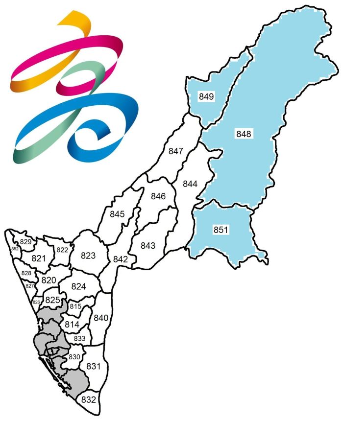
 |  |  | Please note that the grey areas on the map in the middle indicate the districts which constituted Kaohsiung City before December 25, 2010, shown more detailed in the map on the right. |
TOP HOME [◆ Special municipalities] [Kaohsiung City]
Legislative representation
COMPOSITION OF ELECTORAL DISTRICTS FOR THE ROC LEGISLATIVE YUAN
| District No. | Covered city districts |
|---|---|
| # 1 | Alian, Dashe, Dashu, Jiaxian, Liugui, Maolin, Meinong, Namaxia, Neimen, Qishan, Shanlin, Taoyuan, Tianliao, Yanchao |
| # 2 | Gangshan, Hunei, Luzhu, Mituo, Qiaotou, Qieding, Yong'an, Ziguan |
| # 3 | Nanzi, Zuoying |
| # 4 | Daliao, Linyuan, Niaosong, Renwu |
| # 5 | Gushan, Qijin, Sanmin, Yancheng |
| # 6 | Sanmin |
| # 7 | Lingya, Qianjin, Qianzhen, Xinxing |
| # 8 | Fengshan |
| # 9 | Qianzhen, Xiaogang |
On Jan. 11, 2019 the CEC announced a redrawing of legislative districts, cutting one seat from Kaohsiung city. An overview of changed electoral districts is shown below (electoral districts 1–4 unchanged!):
| District No. | Old composition (city districts) | New composition (city districts) |
|---|---|---|
| Kaohsiung 5 | Gushan, Qijin, Sanmin, Yancheng | Sanmin and part of Lingya (eight boroughs) |
| Kaohsiung 6 | Sanmin | Gushan, Qianjin, Xinxing, and Yancheng as well as the remainder of Lingya (61 boroughs) |
| Kaohsiung 7 | Lingya, Qianjin, Qianzhen, Xinxing | Fengshan |
| Kaohsiung 8 | Fengshan | Qianzhen, Qijin, Xiaogang |
| Kaohsiung 9 | Qianzhen, Xiaogang | <Abolished> |
LEGISLATIVE REPRESENTATION SINCE 2008—(By-elections not included)
| # | Winner 2008 | Winner 2012 | Winner 2016 | Winner 2020 | Winner 2024 |
|---|---|---|---|---|---|
| 1 | Chung Shao-ho, KMT | ||||
| 2 | Lin Yi-shih, KMT | ||||
| 3 | Lee Po-yi, DPP | ||||
| 4 | Chen Chi-yu, DPP | ||||
| 5 | |||||
| 6 | Ho Tsai-feng, KMT | Chao Tien-lin, DPP | Huang Jie, DPP | ||
| 7 | Lee Fu-hsing, KMT | ||||
| 8 | Chiang Lin-chun, KMT | ||||
| 9 | Kuo Wen-cheng, DPP | Lin Kuo-cheng, KMT | Lai Jui-lung, DPP | ||
For detailed information about legislative representation in the ROC go to the page Legislative Yuan (Parliament).
TOP HOME [◆ Special municipalities] [Kaohsiung City]
Additional information about Kaohsiung city
PROTECTED AREAS IN THE CITY—Dongsha Atoll National Park 東沙環礁國家公園; [part of] Yushan National Park 玉山國家公園; Shoushan National Nature Park 壽山國家自然公園; Chuyunshan Nature Reserve 出雲山自然保留區; Wushanding Mud Volcano Nature Reserve 烏山頂泥火山自然保留區; Kaohsiung City Nanzihsian River Wildlife Refuge 高雄市那瑪夏區楠梓仙溪野生動物保護區; Jiahsian Sihde Fossil Reserve 甲仙四德化石自然保護區; Shihbaluohanshan Forest Reserve 十八羅漢山自然保護區; Nanzihsian River Major Wildlife Habitat 楠梓仙溪野生動物重要棲息環境; [part of] Shuangguei Lake Major Wildlife Habitat 雙鬼湖野生動物重要棲息環境
SELECTED SIGHTS—Shoushan 壽山, Love River 愛河, Zuoying Old City 左營舊城, Former British Consulate at Takao 打狗英國領事館, Tuntex Sky Tower 高雄 85 大樓, Dream Mall 夢時代購物中心, Kaohsiung Lighthouse Park 高雄燈塔, Meinong Hakka Culture Museum 美濃客家文物館, Taiwan Sugar Museum 台灣糖業博物館, Fo Guang Shan Buddha Memorial Center 佛光山佛陀紀念館, Liuhe Night Market 六合夜市
SEISMIC ACTIVITY—The table directly below is an excerpt of a list showing all major earthquakes in the Taiwan area since 1945 and presents major quakes with epicenter in Kaohsiung City.
| Year | Date | Magnitude | Depth | Fatalities | Location of epicenter | Coordinates |
|---|---|---|---|---|---|---|
| 2010 | March 4 | 6.4 | 22.6 km | — | Maolin 851 ℹ ℹ | 120.71° E, 22.97° N |
| 2016 | Feb. 6 | 6.6 | 14.6 km | 117 | Meinong 843 ℹ ℹ ℹ | 120.54° E, 22.92° N |
TOP HOME [◆ Special municipalities] [Kaohsiung City]
New Taipei City 🚩
- Area and population
- City administration
- Legislative representation
- Additional information about New Taipei City
+++++ ⤒ 🏠 [next entity] [previous entity] +++++
| ✉ New Taipei City Government 新北市 市政府 | |
| No. 161 Zhongshan Road Sec. 1, Banqiao District, New Taipei City 22001, Taiwan ROC [22001 新北市板橋區中山路 1 段 161 號] ———————————— 🌏 New Taipei City Government – Web link |
 |
| Old logo of Taipei County (before Dec. 25, 2010) |  |
Note: Before it was renamed and upgraded to Special Municipality on Dec. 25, 2010, New Taipei City was called Taipei County (Taibei xian 台北縣). After an amendment to the Local Government Act (difang zhidufa 地方制度法) was promulgated on May 3, 2007, the status of Taipei County was upgraded to "quasi-special municipality" on Oct. 1, 2007.
Area and population
AREA—2,052.5667 km², including 321.1306 km² indigenous communities (15.645 percent of New Taipei City's area). Click here to see a map showing the indigenous communities in the city highlighted with torquoise colour. According to Google Earth, the city limits are located between latitude 24° 24' 00"–25° 10' 12" N and longitude 121° 09' 36"–122° 00' 00" E.
Adjacent counties/cities: Taipei City, Keelung City, Taoyuan City, Yilan County
POPULATION DEVELOPMENT SINCE 1974—(figures for the end of the year)
| Year | Inhabitants | Year | Inhabitants | Year | Inhabitants | Year | Inhabitants | |||
|---|---|---|---|---|---|---|---|---|---|---|
| 1974 | 1,531,336 | 1987 | 2,800,881 | 2000 | 3,567,896 | 2013 | 3,954,929 | |||
| 1975 | 1,629,105 | 1988 | 2,888,326 | 2001 | 3,610,252 | 2014 | 3,966,818 | |||
| 1976 | 1,757,238 | 1989 | 2,970,205 | 2002 | 3,641,446 | 2015 | 3,970,644 | |||
| 1977 | 1,871,774 | 1990 | 3,048,034 | 2003 | 3,676,533 | 2016 | 3,979,208 | |||
| 1978 | 2,006,804 | 1991 | 3,107,278 | 2004 | 3,708,099 | 2017 | 3,986,689 | |||
| 1979 | 2,135,007 | 1992 | 3,162,346 | 2005 | 3,736,677 | 2018 | 3,995,717 | |||
| 1980 | 2,258,757 | 1993 | 3,222,629 | 2006 | 3,767,095 | 2019 | 4,018,696 | |||
| 1981 | 2,354,858 | 1994 | 3,260,731 | 2007 | 3,798,015 | 2020 | 4,030,954 | |||
| 1982 | 2,445,129 | 1995 | 3,305,615 | 2008 | 3,833,730 | 2021 | 4,008,113 | |||
| 1983 | 2,514,191 | 1996 | 3,355,299 | 2009 | 3,873,653 | 2022 | 3,995,551 | |||
| 1984 | 2,588,396 | 1997 | 3,420,535 | 2010 | 3,897,367 | 2023 | 4,041,120 | |||
| 1985 | 2,663,683 | 1998 | 3,459,624 | 2011 | 3,916,451 | 2024 | 4,047,001 | |||
| 1986 | 2,727,510 | 1999 | 3,510,917 | 2012 | 3,939,305 | 2025 | 4,044,831 |
Major indigenous peoples: Atayal (see also The indigenous peoples in contemporary Taiwan)
General population statistics about Taiwan / the ROC can be found here.
TOP HOME [◆ Special municipalities] [New Taipei City]
City administration
● New Taipei City mayors since 1989
| Tenure | Name | Born/Died | Political Affiliation |
|---|---|---|---|
| 12/1989—12/1997 | Yu Ching 尤清 | b. 1942 | DPP |
| 12/1997—12/2005 | Su Tseng-chang 蘇貞昌 | b. 1947 | DPP |
| 5/2004—12/2005 @ | Lin Si-yao 林錫耀 | b. 1961 | DPP |
| 12/2005—12/2010 | Chou Hsi-wei 周錫瑋 | b. 1958 | KMT |
| 12/2010—12/2018 | Eric Chu 朱立倫 | b. 1961 | KMT |
| 12/2018— | Hou Yu-ih 侯友宜 | b. 1957 | KMT |
● Administrative division
29 districts, including 1 Mountain Aborigines community
(Ⓜ):
| Bali District 八里區 249 Banqiao District 板橋區 220 Danshui District 淡水區 251 Gongliao District 貢寮區 228 (aka Kungliao District) Jinshan District 金山區 208 Linkou District 林口區 244 Luzhou District 蘆洲區 247 Pinglin District 坪林區 232 Pingxi District 平溪區 226 |
Ruifang District 瑞芳區 224 Sanchong District 三重區 241 Sanxia District 三峽區 237 Sanzhi District 三芝區 252 Shenkeng District 深坑區 222 Shiding District 石碇區 223 Shimen District 石門區 253 Shuangxi District 雙溪區 227 Shulin District 樹林區 238 Taishan District 泰山區 243 |
Tucheng District 土城區 236 Wanli District 萬里區 207 Wugu District 五股區 248 Wulai District 烏來區 233 Ⓜ Xindian District 新店區 231 Xinzhuang District 新莊區 242 Xizhi District 汐止區 221 Yingge District 鶯歌區 239 Yonghe District 永和區 234 Zhonghe District 中和區 235 |
 |  | For a map which highlights the indigenous communities in New Taipei City in turquoise colour please click here. |
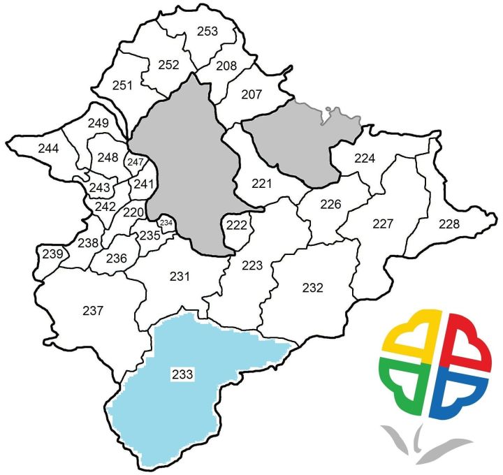
TOP HOME [◆ Special municipalities] [New Taipei City]
Legislative representation
COMPOSITION OF ELECTORAL DISTRICTS FOR THE ROC LEGISLATIVE YUAN
| District No. | Covered city districts |
|---|---|
| # 1 | Bali, Danshui, Linkou, Sanzhi, Shimen |
| # 2 | Luzhou, Sanchong, Wugu |
| # 3 | Sanchong |
| # 4 | Xinzhuang |
| # 5 | Shulin, Xinzhuang, Yingge |
| # 6 | Banqiao |
| # 7 | Banqiao |
| # 8 | Zhonghe |
| # 9 | Yonghe, Zhonghe |
| # 10 | Sanxia, Tucheng |
| # 11 | Pinglin, Shenkeng, Shiding, Wulai, Xindian |
| # 12 | Gongliao, Jinshan, Pingxi, Ruifang, Shuangxi, Wanli, Xizhi |
LEGISLATIVE REPRESENTATION SINCE 2008—(By-elections not included)
| # | Winner 2008 | Winner 2012 | Winner 2016 | Winner 2020 | Winner 2024 |
|---|---|---|---|---|---|
| 1 | Lu Sun-ling, DPP | ||||
| 2 | |||||
| 3 | Yu Tian, DPP | Yu Tien, DPP | Lee Kuen-cheng, DPP | ||
| 4 | |||||
| 5 | |||||
| 6 | |||||
| 7 | Wu Ching-chih, KMT | Chiang Hui-chen, KMT | Yeh Yuan-chih, KMT | ||
| 8 | Chang Chih-lun, KMT | ||||
| 9 | |||||
| 10 | |||||
| 11 | |||||
| 12 | Huang Kuo-chang, NPP | Lai Pin-yu, DPP | Liao Hsien-hsiang, KMT | ||
For detailed information about legislative representation in the ROC go to the page Legislative Yuan (Parliament).
TOP HOME [◆ Special municipalities] [New Taipei City]
Additional information about New Taipei City
PROTECTED AREAS IN THE CITY—[part of] Yangmingshan National Park 陽明山國家公園; [part of] Hapen Nature Reserve 哈盆自然保留區; Pinglin Keteleeria Nature Reserve 坪林台灣油杉自然保留區; Danshuei River Mangrove Nature Reserve 淡水河紅樹林自然保留區; [part of] Chatianshan Nature Reserve 插天山自然保留區; Wazihwei Nature Reserve 挖子尾自然保留區; Feitsui Reservoir Snake-eating Turtle Wildlife Refuge 翡翠水庫食蛇龜野生動物保護區; [part of] Cilan (or Chilan) Major Wildlife Habitat 棲蘭野生動物重要棲息環境; Feitsui Reservoir Snake-eating Turtle Major Wildlife Habitat 翡翠水庫食蛇龜野生動物重要棲息環境; North Shore Coastal Protection Area 北海岸沿海保護區; [part of] Danshuei Estuary Protection Area 淡水河口保護區; [part of] Northeast Coastal Protection Area 東北角沿海保護區
SELECTED SIGHTS—Yeliu 野柳, Wulai 烏來, Jiufen 九份, Longdong 龍洞, Tamsui 淡水, Fort San Domingo 紅毛城, Lin Family Mansion and Garden 林家花園, Ju Ming Museum 朱銘美術館, Fugueijiao Lighthouse 富貴角燈塔 near the island's northernmost point, Cape San Diego aka Cape Santiago 三貂角 and SDJ Lighthouse 三貂角燈塔 near the island's easternmost point, Zushi Temple 清水祖師廟, Luku Incident Memorial Park 鹿窟事件紀念公園, Yingge Ceramics Museum 鶯歌陶瓷博物館, Museum of World Religions 世界宗教博物館, Shihsanhang Museum of Archaeology 十三行博物館, Tamsui Historical Museum 淡水古蹟博物館, Gold Museum 黃金博物館, Ankang Guesthouse 安康接待室 (former White Terror era detention center)
SEISMIC ACTIVITY—The table directly below is an excerpt of a list showing all major earthquakes in the Taiwan area since 1945 and presents major quakes with epicenter in and off New Taipei City.
| Year | Date | Magnitude | Depth | Fatalities | Location of epicenter | Coordinates |
|---|---|---|---|---|---|---|
| 1959 | April 27 | 7.5 | 150 km | 1 | ~ 49.9 km off Gongliao 228 ℹ | 122.5° E, 25° N |
| 2016 | May 31 | 6.9 | 256.9 km | — | ~ 86.1 km off Ruifang 224 / Gongliao 228 ℹ ℹ | 122.68° E, 25.49° N |
| 2026 | May 1 | 6.1 | 98.3 km | — | ~ 11.3 km off Gongliao 228 ℹ ℹ | 122.08° E, 24.93° N |
TOP HOME [◆ Special municipalities] [New Taipei City]
Taoyuan City 🚩
- Area and population
- City administration
- Legislative representation
- Additional information about Taoyuan city
+++++ ⤒ 🏠 [next entity] [previous entity] +++++
| ✉ Taoyuan City Government 桃園市 市政府 | |
| No. 1 Shianfu Road, Taoyuan District, Taoyuan City 33001, Taiwan ROC [33001 桃園市桃園區縣府路 1 號] ———————————— 🌏 Taoyuan City Government – Web link |
 |
Note: Before it was renamed and upgraded to Special Municipality on Dec. 25, 2014, Taoyuan City was called Taoyuan County (Taoyuan xian 桃園縣). The status of Taoyuan County was upgraded to "quasi-special municipality" on Jan. 1, 2011.
Area and population
AREA—1,220.9540 km², including 350.7775 km² indigenous communities (28.729 percent of Taoyuan City's area). Click here to see a map showing the indigenous communities in the city highlighted with torquoise colour. According to Google Earth, the city limits are located between latitude 24° 21' 00"–25° 04' 12" N and longitude 120° 35' 24"–121° 16' 48" E.
Adjacent counties/cities: New Taipei City, Yilan County, Hsinchu County
POPULATION DEVELOPMENT SINCE 1974—(figures for the end of the year)
| Year | Inhabitants | Year | Inhabitants | Year | Inhabitants | Year | Inhabitants | |||
|---|---|---|---|---|---|---|---|---|---|---|
| 1974 | 834,049 | 1987 | 1,259,503 | 2000 | 1,732,617 | 2013 | 2,044,023 | |||
| 1975 | 861,792 | 1988 | 1,288,626 | 2001 | 1,762,963 | 2014 | 2,058,328 | |||
| 1976 | 896,426 | 1989 | 1,320,359 | 2002 | 1,792,603 | 2015 | 2,105,780 | |||
| 1977 | 931,597 | 1990 | 1,355,175 | 2003 | 1,822,075 | 2016 | 2,147,763 | |||
| 1978 | 969,620 | 1991 | 1,385,165 | 2004 | 1,853,029 | 2017 | 2,188,017 | |||
| 1979 | 1,013,033 | 1992 | 1,415,546 | 2005 | 1,880,316 | 2018 | 2,220,872 | |||
| 1980 | 1,052,800 | 1993 | 1,448,186 | 2006 | 1,911,161 | 2019 | 2,249,037 | |||
| 1981 | 1,093,621 | 1994 | 1,483,955 | 2007 | 1,934,968 | 2020 | 2,268,807 | |||
| 1982 | 1,129,576 | 1995 | 1,524,127 | 2008 | 1,958,686 | 2021 | 2,272,391 | |||
| 1983 | 1,160,709 | 1996 | 1,570,456 | 2009 | 1,978,782 | 2022 | 2,281,464 | |||
| 1984 | 1,189,752 | 1997 | 1,614,471 | 2010 | 2,002,060 | 2023 | 2,317,445 | |||
| 1985 | 1,211,249 | 1998 | 1,650,984 | 2011 | 2,013,305 | 2024 | 2,338,648 | |||
| 1986 | 1,232,209 | 1999 | 1,691,292 | 2012 | 2,030,161 | 2025 | 2,355,106 |
Major indigenous peoples: Atayal (see also The indigenous peoples in contemporary Taiwan)
General population statistics about Taiwan / the ROC can be found here.
TOP HOME [◆ Special municipalities] [Taoyuan City]
City administration
● Taoyuan City mayors since 1989
| Tenure | Name | Born/Died | Political Affiliation |
|---|---|---|---|
| 12/1989—11/1996 † | Liu Pang-you 劉邦友 | 1943-1996 | KMT |
| 11/1996—3/1997 @ | Liao Pen-yang 廖本洋 | N/A | N/A |
| 3/1997—5/2000 | Annette Lu 呂秀蓮 | b. 1944 | DPP |
| 5/2000—12/2001 @ | Hsu Ying-shen 許應深 | b. 1948 | DPP |
| 12/2001—12/2009 | Eric Chu 朱立倫 | b. 1961 | KMT |
| 12/2009—12/2014 | John Wu 吳志揚 | b. 1969 | KMT |
| 12/2014—12/2022 | Cheng Wen-tsang 鄭文燦 | b. 1967 | DPP |
| 12/2022— | Simon Chang San-cheng 張善政 | b. 1954 | KMT |
● Administrative division
13 districts, including 1 Mountain Aborigines community
(Ⓜ):
| Bade District 八德區 334 Daxi District 大溪區 335 Dayuan District 大園區 337 Fuxing District 復興區 336 Ⓜ Guanyin District 觀音區 328 |
Guishan District 龜山區 333 Longtan District 龍潭區 325 Luzhu District 蘆竹區 338 Pingzhen District 平鎮區 324 Taoyuan District 桃園區 330 |
Xinwu District 新屋區 327 Yangmei District 楊梅區 326 Zhongli District 中壢區 320 |
 |  | For a map which highlights the indigenous communities in Taoyuan City in turquoise colour please click here. |
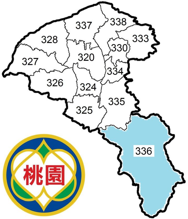
TOP HOME [◆ Special municipalities] [Taoyuan City]
Legislative representation
COMPOSITION OF ELECTORAL DISTRICTS FOR THE ROC LEGISLATIVE YUAN
| District No. | Covered city districts | District No. | Covered city districts | |
|---|---|---|---|---|
| # 1 | Guishan, Luzhu, Taoyuan | # 4 | Taoyuan | |
| # 2 | Dayuan, Guanyin, Xinwu, Yangmei | # 5 | Longtan, Pingzhen | |
| # 3 | Zhongli | # 6 | Bade, Daxi, Fuxing, Zhongli |
LEGISLATIVE REPRESENTATION SINCE 2008—(By-elections not included)
| # | Winner 2008 | Winner 2012 | Winner 2016 | Winner 2020 | Winner 2024 |
|---|---|---|---|---|---|
| 1 | Niu Hsu-ting, KMT | ||||
| 2 | Chen Lai Su-mei, DPP | Huang Shih-chieh, DPP | Tu Chuan-chi, KMT | ||
| 3 | John Wu, KMT | ||||
| 4 | Cheng Pao-ching, DPP | ||||
| 5 | Helen Chu, KMT | ||||
| 6 | Chiu Jo-hua, KMT | ||||
For detailed information about legislative representation in the ROC go to the page Legislative Yuan (Parliament).
TOP HOME [◆ Special municipalities] [Taoyuan City]
Additional information about Taoyuan city
PROTECTED AREAS IN THE CITY—[part of] Yuanyang Lake Nature Reserve 鴛鴦湖自然保留區; [part of] Chatianshan Nature Reserve 插天山自然保留區; Taoyuan Gaorong Wildlife Refuge 桃園高榮野生動物保護區; Taoyuan Guan-Xin Algal Reefs Ecosystem Wildlife Refuge 桃園觀新藻礁生態系野生動物保護區; [part of] Cilan (or Chilan) Major Wildlife Habitat 棲蘭野生動物重要棲息環境; Taoyuan Gaorong Major Wildlife Habitat 桃園高榮野生動物重要棲息環境; Taoyuan Guan-Xin Algal Reefs Ecosystem Major Wildlife Habitat 桃園觀新藻礁生態系野生動物重要棲息環境
SELECTED SIGHTS—Daxi Old Street 大溪老街, Cihu Mausoleum 慈湖陵寢 with the Cihu Memorial Sculpture Park 慈湖紀念雕塑公園, Taoyuan Martyr's Shrine 桃園忠烈祠, Lalashan 拉拉山, Window on China Theme Park 小人國主題樂園, 1895 Yiweibaotai Memorial Park 乙未保台紀念公園
TOP HOME [◆ Special municipalities] [Taoyuan City]
Taichung City 🚩
- Area and population
- City administration
- Legislative representation
- Additional information about Taichung city
+++++ ⤒ 🏠 [next entity] [previous entity] +++++
| ✉ Taichung City Government 台中市 市政府 | |
| No. 89 Taijhonggang Road Sec. 2, Xitun District, Taichung City 40756, Taiwan ROC [40756 台中市西屯區台中港路 2 段 89 號] ———————————— 🌏 Taichung City Government – Web link |
|
| Old logo of Taichung City (before Dec. 25, 2010) |  |
Note: On Dec. 25, 2010, Taichung City was merged with Taichung County and elevated to the status of Special Municipality.
Please note that the seat of the former Taichung County Government is now used by the Taichung City Government as Yangming Civic Center 台中市政府陽明市政大樓, address: No. 36 Yangming Street, Fongyuan District, Taichung City 42007, Taiwan ROC [42007 台中市豐原區陽明街 36 號].
Area and population
AREA—2,214.8968 km², including 1,037.8192 km² indigenous communities (46.856 percent of Taichung City's area). Click here to see a map showing the indigenous communities in the city highlighted with torquoise colour. According to Google Earth, the city limits are located between latitude 23° 35' 24"–24° 15' 36" N and longitude 120° 16' 48"–121° 16' 12" E.
Adjacent counties/cities: Yilan County, Hsinchu County, Miaoli County, Changhua County, Nantou County, Hualien County
POPULATION DEVELOPMENT SINCE 1974—(figures for the end of the year)
| Year | Inhabitants | Year | Inhabitants | Year | Inhabitants | Year | Inhabitants | |||
|---|---|---|---|---|---|---|---|---|---|---|
| 1974 | 1,369,758 | 1987 | 1,898,597 | 2000 | 2,460,098 | 2013 | 2,701,661 | |||
| 1975 | 1,408,444 | 1988 | 1,940,851 | 2001 | 2,485,968 | 2014 | 2,719,835 | |||
| 1976 | 1,447,858 | 1989 | 1,977,649 | 2002 | 2,508,495 | 2015 | 2,744,445 | |||
| 1977 | 1,483,686 | 1990 | 2,019,959 | 2003 | 2,529,763 | 2016 | 2,767,239 | |||
| 1978 | 1,520,643 | 1991 | 2,061,036 | 2004 | 2,548,332 | 2017 | 2,787,070 | |||
| 1979 | 1,560,923 | 1992 | 2,112,465 | 2005 | 2,566,220 | 2018 | 2,803,894 | |||
| 1980 | 1,606,603 | 1993 | 2,167,852 | 2006 | 2,587,828 | 2019 | 2,815,261 | |||
| 1981 | 1,651,296 | 1994 | 2,212,603 | 2007 | 2,606,794 | 2020 | 2,820,787 | |||
| 1982 | 1,692,876 | 1995 | 2,257,950 | 2008 | 2,624,072 | 2021 | 2,813,490 | |||
| 1983 | 1,731,182 | 1996 | 2,303,762 | 2009 | 2,635,761 | 2022 | 2,814,459 | |||
| 1984 | 1,775,695 | 1997 | 2,349,722 | 2010 | 2,648,419 | 2023 | 2,845,909 | |||
| 1985 | 1,817,125 | 1998 | 2,385,367 | 2011 | 2,664,394 | 2024 | 2,860,601 | |||
| 1986 | 1,856,587 | 1999 | 2,421,996 | 2012 | 2,684,893 | 2025 | 2,868,465 |
Figures for 1974–2009 represent Taichung city and Taichung county combined (separate figures for that period can be found here). According to MOI statistics, at the end of 2010—when Taichung City and Taichung County were merged—the former had 1,082,299 inhabitants, the latter 1,566,120 inhabitants.
Major indigenous peoples: Atayal (see also The indigenous peoples in contemporary Taiwan)
General population statistics about Taiwan / the ROC can be found here.
TOP HOME [◆ Special municipalities] [Taichung City]
City administration
● Taichung City mayors since 1989
| Tenure | Name | Born/Died | Political Affiliation |
|---|---|---|---|
| 7/1989—12/1989 @ | Hwang Ching-fong 黃鏡峰 | N/A | N/A |
| 12/1989—12/1997 | Lin Po-jung 林柏榕 | b. 1936 | KMT |
| 10/1995—4/1996 @ | Chen Cheng-hsiung 陳正雄 | b. 1937 | KMT |
| 6/1996—7/1997 @ | Lin Hsueh-cheng 林學正 | N/A | N/A |
| 12/1997—12/2001 | Chang Wen-ying 張溫鷹 | b. 1950 | DPP |
| 12/2001—12/2014 | Jason Hu 胡志強 | b. 1948 | KMT |
| 12/2014—12/2018 | Lin Chia-lung 林佳龍 | b. 1964 | DPP |
| 12/2018— | Lu Shiow-yen 盧秀燕 | b. 1961 | KMT |
● Administrative division
29 districts (red numbers indicate districts of old Taichung City before 2010), including 1 Mountain Aborigines community
(Ⓜ):
| Beitun District 北屯區 406 Central District 中區 400 Da'an District 大安區 439 Dadu District 大肚區 432 Dajia District 大甲區 437 Dali District 大里區 412 Daya District 大雅區 428 Dongshi District 東勢區 423 East District 東區 401 Fengyuan District 豐原區 420 |
Heping District 和平區 424 Ⓜ Houli District 后里區 421 Longjing District 龍井區 434 Nantun District 南屯區 408 North District 北區 404 Qingshui District 清水區 436 Shalu District 沙鹿區 433 Shengang District 神岡區 429 Shigang District 石岡區 422 South District 南區 402 |
Taiping District 太平區 411 Tanzi District 潭子區 427 Waipu District 外埔區 438 West District 西區 403 Wufeng District 霧峰區 413 Wuqi District 梧棲區 435 Wuri District 烏日區 414 Xinshe District 新社區 426 Xitun District 西屯區 407 |


Please note that the grey areas on the map in the middle indicate the districts which constituted Taichung City before Dec. 25, 2010, shown more detailed in the map above right.
For a map which highlights the indigenous communities in Taichung City in turquoise colour please click here.
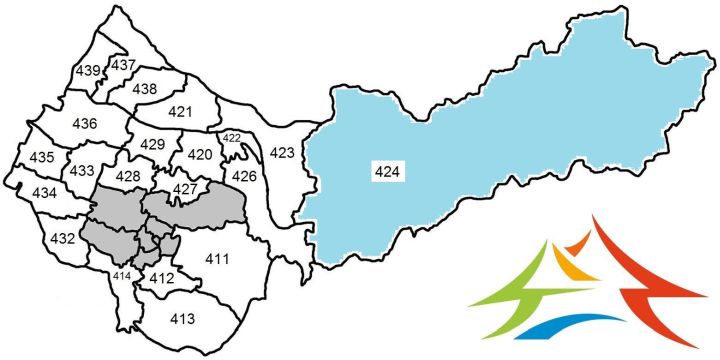
TOP HOME [◆ Special municipalities] [Taichung City]
Legislative representation
COMPOSITION OF ELECTORAL DISTRICTS FOR THE ROC LEGISLATIVE YUAN
| District No. | Covered city districts |
|---|---|
| # 1 | Da'an, Dajia, Qingshui, Waipu, Wuqi |
| # 2 | Dadu, Dali, Longjing, Shalu, Wufeng, Wuri |
| # 3 | Daya, Houli, Shengang, Tanzi |
| # 4 | Nantun, Xitun |
| # 5 | Beitun, North |
| # 6 | Central, East, South, West |
| # 7 | Dali, Taiping |
| # 8 | Dongshi, Fengyuan, Heping, Shigang, Xinshe |
Please note that according to an announcement made by the CEC on Jan. 11, 2019 concerning the 2020 elections for the Tenth Legislative Yuan, Taichung's boroughs Donghu 東湖 and Sihu 西湖 are to be incorporated into Taichung's 7th electoral district from the 2nd, joining the rest of Dali District.
LEGISLATIVE REPRESENTATION SINCE 2008—(By-elections not included)
| # | Winner 2008 | Winner 2012 | Winner 2016 | Winner 2020 | Winner 2024 |
|---|---|---|---|---|---|
| 1 | Liu Chuan-chung, KMT | ||||
| 2 | Yen Kuan-hen, KMT | Wonda Chen, TSP | Yen Kuan-hen, KMT | ||
| 3 | Hung Tzu-yung, NPP | ||||
| 4 | Liao Wei-hsiang, KMT | ||||
| 5 | Chuang Ching-cheng, DPP | Huang Chien-hao, KMT | |||
| 6 | Hwang Yih-jiau, KMT | Lin Chia-lung, DPP | Lo Ting-wei, KMT | ||
| 7 | Chiang Lien-fu, KMT | ||||
| 8 | Shyu Jong-shyong, KMT | ||||
For detailed information about legislative representation in the ROC go to the page Legislative Yuan (Parliament).
TOP HOME [◆ Special municipalities] [Taichung City]
Additional information about Taichung city
PROTECTED AREAS IN THE CITY—[part of] Taroko National Park 太魯閣國家公園; [part of] Shei-pa National Park 雪霸國家公園; [part of] Mt. Chiu-chiu Nature Reserve 九九峰自然保留區; [part of] Dadu Estuary Wildlife Refuge 大肚溪口野生動物保護區; Formosan Landlocked Salmon Refuge 櫻花鉤吻鮭野生動物保護區; Gaomei Wildlife Refuge 臺中市高美野生動物保護區; [part of] Syueba Nature Reserve 雪霸自然保護區; Wuling Formosan Landlocked Salmon Major Habitat 武陵櫻花鉤吻鮭重要棲息環境; [part of] Dadu Estuary Major Wildlife Habitat 大肚溪口野生動物重要棲息環境; Gaomei Major Wildlife Habitat 高美野生動物重要棲息環境
SELECTED SIGHTS—Pao Hueh Temple 寶覺禪寺, Wufeng Lin Family Mansion and Garden 霧峰林家宅園, Fengjia Night Market 逢甲夜市, National Taiwan Museum of Fine Arts 國立台灣美術館, National Museum of Natural Science 國立自然科學博物館, Assembly Affairs Museum, Legislative Yuan 立法院議政博物館
TOP HOME [◆ Special municipalities] [Taichung City]
Tainan City 🚩
- Area and population
- City administration
- Legislative representation
- Additional information about Tainan city
+++++ ⤒ 🏠 [next entity] [previous entity] +++++
| ✉ Tainan City Government 台南市 市政府 | |
| No. 6 Yonghua Road Sec. 2, Anping District, Tainan City 70801, Taiwan ROC [70801 台南市安平區永華路 2 段 6 號] ———————————— 🌏 Tainan City Government – Web link |
 |
| Old logo of Tainan City (before Dec. 25, 2010) |  |
Note: On Dec. 25, 2010, Tainan City was merged with Tainan County and elevated to the status of Special Municipality. The seat of the former Tainan County Government is now used by the Tainan City Government as MinJhih Civic Center 民治市政中心, address: No. 36 Minjhih Road, Sinying District, Tainan City 73001, Taiwan ROC [73001 台南市新營區民治路 36 號].
Area and population
AREA—2,191.6531 km² (no indigenous communities). According to Google Earth, the city limits are located between latitude 22° 31' 48"–23° 14' 24" N and longitude 120° 01' 12"–120° 23' 24" E.
Adjacent counties/cities: Chiayi County, Kaohsiung City
POPULATION DEVELOPMENT SINCE 1974—(figures for the end of the year)
| Year | Inhabitants | Year | Inhabitants | Year | Inhabitants | Year | Inhabitants | |||
|---|---|---|---|---|---|---|---|---|---|---|
| 1974 | 1,450,168 | 1987 | 1,663,293 | 2000 | 1,842,337 | 2013 | 1,883,208 | |||
| 1975 | 1,466,643 | 1988 | 1,676,909 | 2001 | 1,848,243 | 2014 | 1,884,284 | |||
| 1976 | 1,486,704 | 1989 | 1,691,154 | 2002 | 1,852,664 | 2015 | 1,885,541 | |||
| 1977 | 1,500,410 | 1990 | 1,710,234 | 2003 | 1,856,461 | 2016 | 1,886,033 | |||
| 1978 | 1,514,208 | 1991 | 1,725,402 | 2004 | 1,860,591 | 2017 | 1,886,522 | |||
| 1979 | 1,530,401 | 1992 | 1,741,289 | 2005 | 1,862,918 | 2018 | 1,883,831 | |||
| 1980 | 1,546,626 | 1993 | 1,759,493 | 2006 | 1,866,727 | 2019 | 1,880,906 | |||
| 1981 | 1,564,360 | 1994 | 1,771,997 | 2007 | 1,870,061 | 2020 | 1,874,917 | |||
| 1982 | 1,586,378 | 1995 | 1,788,612 | 2008 | 1,873,005 | 2021 | 1,862,059 | |||
| 1983 | 1,605,601 | 1996 | 1,799,940 | 2009 | 1,875,406 | 2022 | 1,852,997 | |||
| 1984 | 1,625,572 | 1997 | 1,814,062 | 2010 | 1,873,794 | 2023 | 1,859,946 | |||
| 1985 | 1,640,669 | 1998 | 1,822,102 | 2011 | 1,876,960 | 2024 | 1,858,651 | |||
| 1986 | 1,649,573 | 1999 | 1,831,783 | 2012 | 1,881,645 | 2025 | 1,852,477 |
Figures for 1974–2009 represent Tainan city and Tainan county combined (separate figures for that period can be found here). According to MOI statistics, at the end of 2010—when Tainan City and Tainan County were merged—the former had 772,273 inhabitants, the latter 1,101,521 inhabitants.
General population statistics about Taiwan / the ROC can be found here.
TOP HOME [◆ Special municipalities] [Tainan City]
City administration
● Tainan City mayors since 1989
| Tenure | Name | Born/Died | Political Affiliation |
|---|---|---|---|
| 12/1989—12/1993 | Lin Wen-hsun 林文雄 | b. 1942 | KMT |
| 12/1993—12/1997 | Shih Chih-ming 施治明 | b. 1952 | KMT |
| 12/1997—12/2001 | George Chang 張燦鍙 | b. 1936 | DPP |
| 12/2001—12/2010 | Hsu Tain-tsair 許添財 | b. 1951 | DPP |
| 12/2010—9/2017 | William Lai Ching-te 賴清德 | b. 1959 | DPP |
| 9/2017—12/2018 @ | Lee Meng-yen 李孟諺 | b. 1966 | Ind. |
| 12/2018— | Huang Wei-che 黃偉哲 | b. 1963 | DPP |
● Administrative division
37 districts (red numbers indicate districts of old Tainan City before 2010):
| Anding District 安定區 745 Annan District 安南區 709 Anping District 安平區 708 Baihe District 白河區 732 Beimen District 北門區 727 Danei District 大內區 742 Dongshan District 東山區 733 East District 東區 701 Guanmiao District 關廟區 718 Guantian District 官田區 720 Guiren District 歸仁區 711 Houbi District 後壁區 731 Jiali District 佳里區 722 |
Jiangjun District 將軍區 725 Liujia District 六甲區 734 Liuying District 柳營區 736 Longqi District 龍崎區 719 Madou District 麻豆區 721 Nanhua District 南化區 716 Nanxi District 楠西區 715 North District 北區 704 Qigu District 七股區 724 Rende District 仁德區 717 Shanhua District 善化區 741 Shanshang District 山上區 743 South District 南區 702 |
West Central District 中西區 700 Xiaying District 下營區 735 Xigang District 西港區 723 Xinhua District 新化區 712 Xinshi District 新市區 744 Xinying District 新營區 730 Xuejia District 學甲區 726 Yanshui District 鹽水區 737 Yongkang District 永康區 710 Yujing District 玉井區 714 Zuozhen District 左鎮區 713 |
 |  |  | Please note that the grey areas on the map in the middle indicate the districts which constituted Tainan City before Dec. 25, 2010, shown more detailed in the map on the right. |
Tainan City has no indigenous communities.
TOP HOME [◆ Special municipalities] [Tainan City]
Legislative representation
COMPOSITION OF ELECTORAL DISTRICTS FOR THE ROC LEGISLATIVE YUAN
| District No. | Covered city districts |
|---|---|
| # 1 | Baihe, Beimen, Dongshan, Guantian, Houbi, Jiangjun, Liujia, Liuying, Xiaying, Xinying, Xuejia, Yanshui |
| # 2 | Anding, Danei, Jiali, Madou, Nanhua, Nanxi, Qigu, Shanhua, Shanshang, Xigang, Xinhua, Xinshi, Yujing, Zuozhen |
| # 3 | Annan, North, West Central |
| # 4 | Anping, East, South |
| # 5 | Guanmiao, Guiren, Longqi, Rende, Yongkang |
On Jan. 11, 2019 the CEC announced a redrawing of legislative districts, adding one seat to Tainan city. An overview of changed electoral districts is shown below:
| District No. | Old composition (city districts) | New composition (city districts) |
|---|---|---|
| Tainan 1 | Baihe, Beimen, Dongshan, Guantian, Houbi, Jiangjun, Liujia, Liuying, Xiaying, Xinying, Xuejia, Yanshui | Baihe, Beimen, Dongshan, Houbi, Jiangjun, Liujia, Liuying, Xiaying, Xinying, Xuejia, Yanshui |
| Tainan 2 | Anding, Danei, Jiali, Madou, Nanhua, Nanxi, Qigu, Shanhua, Shanshang, Xigang, Xinhua, Xinshi, Yujing, Zuozhen | Anding, Danei, Guantian, Jiali, Madou, Nanhua, Nanxi, Qigu, Shanhua, Shanshang, Xigang, Yujing, Zuozhen |
| Tainan 3 | Annan, North, West Central | Annan, North |
| Tainan 4 | Anping, East, South | Xinshi, Xinhua, Yongkang |
| Tainan 5 | Guanmiao, Guiren, Longqi, Rende, Yongkang | Anping, South, West Central as well as part of East District (16 boroughs) |
| Tainan 6 | <Did not exist> | Guanmiao, Guiren, Longqi, Rende as well as the remainder of East District (29 boroughs) |
LEGISLATIVE REPRESENTATION SINCE 2008—(By-elections not included)
| # | Winner 2008 | Winner 2012 | Winner 2016 | Winner 2020 | Winner 2024 |
|---|---|---|---|---|---|
| 1 | |||||
| 2 | |||||
| 3 | |||||
| 4 | William Lai, DPP | Hsu Tain-tsair, DPP | Lin Chun-hsien, DPP | ||
| 5 | Lee Chun-yee, DPP | Mark Chen, DPP | Wang Ding-yu, DPP | ||
| 6 | |||||
For detailed information about legislative representation in the ROC go to the page Legislative Yuan (Parliament).
TOP HOME [◆ Special municipalities] [Tainan City]
Additional information about Tainan city
PROTECTED AREAS IN THE CITY—[part of] Taijiang National Park 台江國家公園; Tainan City Sihcao Wildlife Refuge 臺南市四草野生動物保護區; Tainan City Zengwun Estuary North Bank Black-faced Spoonbill Refuge 臺南縣曾文溪口北岸黑面琵鷺動物保護區; Zengwun Estuary Major Wildlife Habitat 曾文溪口野生動物重要棲息環境; Sicao Major Wildlife Habitat 四草野生動物重要棲息環境; Beimen Coastal Protection Area 北門沿海保護區
SELECTED SIGHTS—Sidian Wumiao 祀典武廟, Confucius Temple 台灣孔廟, Fort Zeelandia 熱蘭遮城 = Anping Fort 安平古堡, Fort Provintia 赤崁樓, Koxinga Shrine 延平郡王祠/鄭成功廟, Tapani Incident Memorial Park 噍吧哖事件紀念園區, Cigu Kuosheng Lighthouse 七股國聖燈塔 near the island's westernmost point, National Museum of Taiwan History 國立臺灣歷史博物館, National Museum of Taiwan Literature 國立臺灣文學館
SEISMIC ACTIVITY—The table directly below is an excerpt of a list showing all major earthquakes in the Taiwan area since 1945 and presents major quakes with epicenter in Tainan City.
| Year | Date | Magnitude | Depth | Fatalities | Location of epicenter | Coordinates |
|---|---|---|---|---|---|---|
| 1946 | Dec. 5 | 6.1 | 5 km | 74 | Xinshi 744 ℹ | 120.33° E, 23.07° N |
| 1964 | Jan. 18 | 6.3 | 18 km | 106 | Nanhua 716 ℹ | 120.6° E, 23.2° N |
TOP HOME [◆ Special municipalities] [Tainan City]
===== ===== ===== ===== =====
◆ Counties in the ROC
(Jump to ROC special municipalities or to ROC county-level cities)
++++++++++ TOP HOME [next chapter] [previous chapter] ++++++++++
Hsinchu County
- Area and population
- County administration
- Legislative representation
- Additional information about Hsinchu county
+++++ ⤒ 🏠 [next entity] [previous entity] +++++
| ✉ Hsinchu County Government 新竹縣 縣政府 | |
| No. 10 Guangming 6th Road, Jhubei City, Hsinchu County 30210, Taiwan ROC [30210 新竹縣竹北市光明六路 10 號] ———————————— 🌏 Hsinchu County Government – Web link |
 |
(Jump to Hsinchu City) (Hsinchu before 1982)
Area and population
AREA—1,427.5369 km², including 880.8268 km² indigenous communities (61.702 percent of Hsinchu County's area). Click here to see a map showing the indigenous communities in the county highlighted with torquoise colour. According to Google Earth, the county limits are located between latitude 24° 15' 00"–24° 33' 36" N and longitude 120° 33' 36"–121° 14' 24" E.
Adjacent counties/cities: Taoyuan City, Yilan County, Hsinchu City, Miaoli County, Taichung City
POPULATION DEVELOPMENT SINCE 1982—(figures for the end of the year)
| Year | Inhabitants | Year | Inhabitants | Year | Inhabitants | Year | Inhabitants | |||
|---|---|---|---|---|---|---|---|---|---|---|
| 1981 | N/A | 1993 | 393,030 | 2005 | 477,677 | 2017 | 552,169 | |||
| 1982 | 364,864 | 1994 | 401,188 | 2006 | 487,692 | 2018 | 557,010 | |||
| 1983 | 365,837 | 1995 | 408,577 | 2007 | 495,821 | 2019 | 563,933 | |||
| 1984 | 366,084 | 1996 | 414,932 | 2008 | 503,273 | 2020 | 570,775 | |||
| 1985 | 366,566 | 1997 | 421,721 | 2009 | 510,882 | 2021 | 575,580 | |||
| 1986 | 367,019 | 1998 | 427,980 | 2010 | 513,015 | 2022 | 580,503 | |||
| 1974 | 366,610 | 1999 | 433,767 | 2011 | 517,641 | 2023 | 589,289 | |||
| 1988 | 368,228 | 2000 | 439,713 | 2012 | 523,993 | 2024 | 594,641 | |||
| 1989 | 370,753 | 2001 | 446,300 | 2013 | 530,486 | 2025 | 597,235 | |||
| 1990 | 374,492 | 2002 | 452,679 | 2014 | 537,630 | |||||
| 1991 | 379,443 | 2003 | 459,287 | 2015 | 542,042 | |||||
| 1992 | 385,668 | 2004 | 467,246 | 2016 | 547,481 | |||||
Please note that before July 1, 1982 Hsinchu county included Hsinchu city, therefore separate figures for Hsinchu county and Hsinchu city are available beginning 1982 only. (See additional remarks below.)
Major indigenous peoples: Saisiyat (see also The indigenous peoples in contemporary Taiwan)
General population statistics about Taiwan / the ROC can be found here.
TOP HOME [◆ Counties] [Hsinchu County]
County administration
● Hsinchu county magistrates since 1989
| Tenure | Name | Born/Died | Political Affiliation |
|---|---|---|---|
| 12/1989—12/1997 | Fan Chen-tzung 范振宗 | b. 1942 | DPP |
| 12/1997—12/2001 | Lin Kwang-hua 林光華 | b. 1945 | DPP |
| 12/2001—12/2009 | Cheng Yung-chin 鄭永金 | b. 1949 | KMT |
| 12/2009—12/2018 | Chiu Ching-chun 邱鏡淳 | b. 1949 | KMT |
| 12/2018— | Yang Wen-ko 楊文科 | b. 1951 | KMT |
● Administrative division
1 city, 3 urban townships, 9 rural townships, including 2 Mountain Aborigines communities
(Ⓜ) and 1 Plains Aborigines community (Ⓟ):
| Baoshan Township 寶山鄉 308 ⒭ Beipu Township 北埔鄉 314 ⒭ Emei Township 峨眉鄉 315 ⒭ Guanxi Township 關西鎮 306 ⒰ Ⓟ Hengshan Township 橫山鄉 312 ⒭ Hukou Township 湖口鄉 303 ⒭ Jianshi Township 尖石鄉 313 ⒭ Ⓜ |
Qionglin Township 芎林鄉 307 ⒭ Wufeng Township 五峰鄉 311 ⒭ Ⓜ Xinfeng Township 新豐鄉 304 ⒭ Xinpu Township 新埔鎮 305 ⒰ Zhubei City 竹北市 302 Zhudong Township 竹東鎮 310 ⒰ |
 |  | For a map which highlights the indigenous communities in Hsinchu County in turquoise colour please click here. |
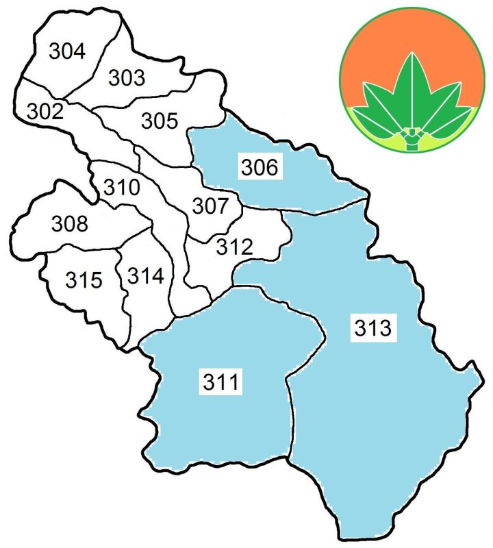
TOP HOME [◆ Counties] [Hsinchu County]
Legislative representation
ELECTORAL DISTRICTS FOR THE ROC LEGISLATIVE YUAN—Since 2008 Hsinchu County as a whole has been represented in the ROC Legislative Yuan by one electoral district only. On Jan. 11, 2019 the CEC announced a redrawing of legislative districts, adding one seat to Hsinchu county. An overview of changed electoral districts is shown below:
| District No. | Old composition | New composition |
|---|---|---|
| Hsinchu # 1 | One electoral district for the whole county! | Guanxi, Hukou, Jianshi, Qionglin, Xinfeng, Xinpu as well as part of Zhubei; with the remainder drawn into Hsinchu County's new 2nd electoral district |
| Hsinchu # 2 | <Did not exist> | Part of Zhubei |
LEGISLATIVE REPRESENTATION SINCE 2008—(By-elections not included)
| # | Winner 2008 | Winner 2012 | Winner 2016 | Winner 2020 | Winner 2024 |
|---|---|---|---|---|---|
| 1 | Chiu Ching-chun, KMT | Hsu Hsin-ying, KMT | Hsu Hsin-ying, KMT | ||
| 2 | |||||
For detailed information about legislative representation in the ROC go to the page Legislative Yuan (Parliament).
TOP HOME [◆ Counties] [Hsinchu County]
Additional information about Hsinchu county
PROTECTED AREAS IN THE COUNTY—[part of] Shei-pa National Park 雪霸國家公園; [part of] Yuanyang Lake Nature Reserve 鴛鴦湖自然保留區; [part of] Syueba Nature Reserve 雪霸自然保護區; [part of] Cilan (or Chilan) Major Wildlife Habitat 棲蘭野生動物重要棲息環境
SELECTED SIGHTS—Beipu Citian Temple 北埔慈天宮, Maitreya Great Tao 峨眉天恩彌勒佛院, Tapung Old Fort 李崠古堡, Leofoo Village Theme Park 六福村主題遊樂園, Former Residence of Zhang Xueliang 張學良故居
TOP HOME [◆ Counties] [Hsinchu County]
Miaoli County
- Area and population
- County administration
- Legislative representation
- Additional information about Miaoli county
+++++ ⤒ 🏠 [next entity] [previous entity] +++++
| ✉ Miaoli County Government 苗栗縣 縣政府 | |
| No. 100 Sianfu Road, Miaoli City, Miaoli County 36001, Taiwan ROC [36001 苗栗縣苗栗市縣府路 100 號] ———————————— 🌏 Miaoli County Government – Web link |
 |
Area and population
AREA—1,820.3149 km², including 859.4389 km² indigenous communities (47.213 percent of Miaoli County's area). Click here to see a map showing the indigenous communities in the county highlighted with torquoise colour. According to Google Earth, the county limits are located between latitude 24° 10' 12"–24° 26' 24" N and longitude 120° 22' 12"–121° 09' 00" E.
Adjacent counties/cities: Hsinchu County, Hsinchu City, Taichung City
POPULATION DEVELOPMENT SINCE 1974—(figures for the end of the year)
| Year | Inhabitants | Year | Inhabitants | Year | Inhabitants | Year | Inhabitants | |||
|---|---|---|---|---|---|---|---|---|---|---|
| 1974 | 537,389 | 1987 | 546,004 | 2000 | 559,703 | 2013 | 565,554 | |||
| 1975 | 538,820 | 1988 | 545,978 | 2001 | 560,640 | 2014 | 567,132 | |||
| 1976 | 541,652 | 1989 | 545,937 | 2002 | 560,766 | 2015 | 563,912 | |||
| 1977 | 542,558 | 1990 | 547,609 | 2003 | 560,903 | 2016 | 559,189 | |||
| 1978 | 542,504 | 1991 | 551,016 | 2004 | 560,643 | 2017 | 553,807 | |||
| 1979 | 541,680 | 1992 | 553,557 | 2005 | 559,944 | 2018 | 548,863 | |||
| 1980 | 542,745 | 1993 | 556,188 | 2006 | 559,986 | 2019 | 545,459 | |||
| 1981 | 545,608 | 1994 | 558,191 | 2007 | 560,163 | 2020 | 542,590 | |||
| 1982 | 548,184 | 1995 | 560,128 | 2008 | 560,397 | 2021 | 538,178 | |||
| 1983 | 548,790 | 1996 | 560,099 | 2009 | 561,744 | 2022 | 535,132 | |||
| 1984 | 549,973 | 1997 | 560,344 | 2010 | 560,968 | 2023 | 534,575 | |||
| 1985 | 550,343 | 1998 | 559,858 | 2011 | 562,010 | 2024 | 532,854 | |||
| 1986 | 548,187 | 1999 | 559,804 | 2012 | 563,976 | 2025 | 531,172 |
Major indigenous peoples: Saisiyat (see also The indigenous peoples in contemporary Taiwan)
General population statistics about Taiwan / the ROC can be found here.
TOP HOME [◆ Counties] [Miaoli County]
County administration
● Miaoli county magistrates since 1989
| Tenure | Name | Born/Died | Political Affiliation |
|---|---|---|---|
| 12/1989—12/1993 | Chang Chiu-hua 張秋華 | b. 1937 | KMT |
| 12/1993—12/1997 | Her Jyh-huei 何智輝 | b. 1950 | KMT |
| 12/1997—12/2005 | Fu Shiue-peng 傅學鵬 | b. 1951 | Ind. |
| 12/2005—12/2014 | Liu Cheng-hong 劉政鴻 | b. 1947 | KMT |
| 12/2014—12/2022 | Hsu Yao-chang 徐耀昌 | b. 1955 | KMT |
| 12/2022— | Chung Tung-chin 鍾東錦 | b. 1963 | Ind. |
● Administrative division
2 cities, 5 urban townships, 11 rural townships, including 1 Mountain Aborigines community
(Ⓜ) and 2 Plains Aborigines communities (Ⓟ):
| Dahu Township 大湖鄉 364 ⒭ Gongguan Township 公館鄉 363 ⒭ Houlong Township 後龍鎮 356 ⒰ Miaoli City 苗栗市 360 Nanzhuang Township 南庄鄉 353 ⒭ Ⓟ Sanwan Township 三灣鄉 352 ⒭ Sanyi Township 三義鄉 367 ⒭ Shitan Township 獅潭鄉 354 ⒭ Ⓟ Tai'an Township 泰安鄉 365 ⒭ Ⓜ |
Tongluo Township 銅鑼鄉 366 ⒭ Tongxiao Township 通霄鎮 357 ⒰ Toufen City 頭份市 351 Touwu Township 頭屋鄉 362 ⒭ Xihu Township 西湖鄉 368 ⒭ Yuanli Township 苑裡鎮 358 ⒰ Zaoqiao Township 造橋鄉 361 ⒭ Zhunan Township 竹南鎮 350 ⒰ Zhuolan Township 卓蘭鎮 369 ⒰ |
Please note that Toufen was an urban township (⒰ / zhen 鎮) before it was upgraded to city (shi 市) on Oct. 5, 2015.
 |  | For a map which highlights the indigenous communities in Miaoli County in turquoise colour please click here. |
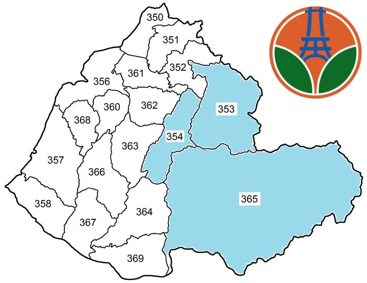
TOP HOME [◆ Counties] [Miaoli County]
Legislative representation
COMPOSITION OF ELECTORAL DISTRICTS FOR THE ROC LEGISLATIVE YUAN
| District No. | Covered cities, townships |
|---|---|
| # 1 | Houlong, Sanyi, Tongluo, Tongxiao, Xihu, Yuanli, Zaoqiao, ZHunan |
| # 2 | Dahu, Gongguan, Miaoli, Nanzhuang, Sanwan, Shitan, Tai'an, Toufen, Touwu, Zhuolan |
LEGISLATIVE REPRESENTATION SINCE 2008—(By-elections not included)
| # | Winner 2008 | Winner 2012 | Winner 2016 | Winner 2020 | Winner 2024 |
|---|---|---|---|---|---|
| 1 | Lee E-tin, KMT | Chen Chao-ming, Ind. | |||
| 2 | Chiu Cheng-chun, KMT | ||||
For detailed information about legislative representation in the ROC go to the page Legislative Yuan (Parliament).
TOP HOME [◆ Counties] [Miaoli County]
Additional information about Miaoli county
PROTECTED AREAS IN THE COUNTY—[part of] Shei-pa National Park 雪霸國家公園; Miaoli Sanyi Huoyanshan Nature Reserve 苗栗三義火炎山自然保留區; [part of] Syueba Nature Reserve 雪霸自然保護區; Guanwu Broad-tailed Swallowtail Major Habitat 觀霧寬尾鳳蝶野生動物重要棲息環境; Syueshankeng River Major Wildlife Habitat 雪山坑溪野生動物重要棲息環境
SELECTED SIGHTS—Hakka Round House 客家圓樓, Longteng Bridge 龍騰橋 aka Yutengping Broken Bridge 魚藤坪斷橋, Sanyi Wood Sculpture Museum 三義木雕博物館, Museum of Saisiat Folklore 賽夏族民俗文物館, Miaoli Pottery Museum 苗栗陶瓷博物館, Miaoli Railway Museum 苗栗鐵道文物展示館
TOP HOME [◆ Counties] [Miaoli County]
Changhua County
- Area and population
- County administration
- Legislative representation
- Additional information about Changhua county
+++++ ⤒ 🏠 [next entity] [previous entity] +++++
| ✉ Changhua County Government 彰化縣 縣政府 | |
| No. 416 Jhongshan Road Sec. 2, Changhua City, Changhua County 50001, Taiwan ROC [50001 彰化縣彰化市中山路 2 段 416 號] ———————————— 🌏 Changhua County Government – Web link |
 |
| Alternative logo |  |
Notes
On May 13, 2022 the MOI expressed opposition to reconstituting Changhua County
as a special municipality, in part due to the region's declining population—at the end of April 2022, the county's
population had dropped to 1,248,262 persons, i. e. below the 1.25 million required by the current law for a region
to be eligible for an upgrade.
In older sources, Changhua is often spelled "Changhwa".
Area and population
AREA—1,074.3960 km² (no indigenous communities). According to Google Earth, the county limits are located between latitude 23° 27' 36"–24° 06' 36" N and longitude 120° 08' 24"–120° 24' 36" E.
Adjacent counties/cities: Taichung City, Nantou County, Yunlin County
POPULATION DEVELOPMENT SINCE 1974—(figures for the end of the year)
| Year | Inhabitants | Year | Inhabitants | Year | Inhabitants | Year | Inhabitants | |||
|---|---|---|---|---|---|---|---|---|---|---|
| 1974 | 1,092,578 | 1987 | 1,229,411 | 2000 | 1,310,531 | 2013 | 1,296,013 | |||
| 1975 | 1,102,835 | 1988 | 1,232,492 | 2001 | 1,313,994 | 2014 | 1,291,474 | |||
| 1976 | 1,117,676 | 1989 | 1,237,186 | 2002 | 1,316,179 | 2015 | 1,289,072 | |||
| 1977 | 1,130,071 | 1990 | 1,245,288 | 2003 | 1,316,443 | 2016 | 1,287,146 | |||
| 1978 | 1,141,957 | 1991 | 1,254,228 | 2004 | 1,316,762 | 2017 | 1,282,458 | |||
| 1979 | 1,153,091 | 1992 | 1,264,955 | 2005 | 1,315,826 | 2018 | 1,277,824 | |||
| 1980 | 1,166,352 | 1993 | 1,273,655 | 2006 | 1,315,034 | 2019 | 1,272,802 | |||
| 1981 | 1,180,612 | 1994 | 1,281,296 | 2007 | 1,314,354 | 2020 | 1,266,670 | |||
| 1982 | 1,193,345 | 1995 | 1,288,447 | 2008 | 1,312,935 | 2021 | 1,255,330 | |||
| 1983 | 1,203,970 | 1996 | 1,292,482 | 2009 | 1,312,467 | 2022 | 1,245,239 | |||
| 1984 | 1,215,477 | 1997 | 1,297,744 | 2010 | 1,307,286 | 2023 | 1,239,048 | |||
| 1985 | 1,223,209 | 1998 | 1,301,467 | 2011 | 1,303,039 | 2024 | 1,225,675 | |||
| 1986 | 1,226,231 | 1999 | 1,305,640 | 2012 | 1,299,868 | 2025 | 1,210,206 |
General population statistics about Taiwan / the ROC can be found here.
TOP HOME [◆ Counties] [Changhua County]
County administration
● Changhua county magistrates since 1989
| Tenure | Name | Born/Died | Political Affiliation |
|---|---|---|---|
| 12/1989—12/1993 | Chou Ching-yu 周清玉 | b. 1944 | DPP |
| 12/1993—12/2001 | Juan Kang-meng 阮剛猛 | b. 1951 | KMT |
| 12/2001—12/2005 | Wong Chin-chu 翁金珠 | b. 1947 | DPP |
| 12/2005—12/2014 | Cho Po-yuan 卓伯源 | b. 1965 | KMT |
| 12/2014—12/2018 | Wei Ming-ku 魏明谷 | b. 1963 | DPP |
| 12/2018— | Wang Hui-mei 王惠美 | b. 1968 | KMT |
● Administrative division
2 cites, 6 urban townships, 18 rural townships:
| Beidou Township 北斗鎮521 ⒰ Changhua City 彰化市 500 Dacheng Township 大城鄉 527 ⒭ Dacun Township 大村鄉 515 ⒭ Erlin Township 二林鎮 526 ⒰ Ershui Township 二水鄉 530 ⒭ Fangyuan Township 芳苑鄉 528 ⒭ Fenyuan Township 芬園鄉 502 ⒭ Fuxing Township 福興鄉 506 ⒭ Hemei Township 和美鎮 508 ⒰ Huatan Township 花壇鄉 503 ⒭ Lugang Township 鹿港鎮 505 ⒰ Pitou Township 埤頭鄉 523 ⒭ |
Puxin Township 埔心鄉 513 ⒭ Puyan Township 埔鹽鄉 516 ⒭ Shengang Township 伸港鄉 509 ⒭ Shetou Township 社頭鄉 511 ⒭ Tianwei Township 田尾鄉 522 ⒭ Tianzhong Township 田中鎮 520 ⒰ Xianxi Township 線西鄉 507 ⒭ Xihu Township 溪湖鎮 514 ⒰ Xiushui Township 秀水鄉 504 ⒭ Xizhou Township 溪州鄉 524 ⒭ Yongjing Township 永靖鄉 512 ⒭ Yuanlin City 員林市 510 Zhutang Township 竹塘鄉 525 ⒭ |
Please note that Yuanlin was an urban township (⒰ / zhen 鎮) before it was upgraded to city (shi 市) on Aug. 8, 2015.
 |
 |
Changhua County has no indigenous communities. |
TOP HOME [◆ Counties] [Changhua County]
Legislative representation
COMPOSITION OF ELECTORAL DISTRICTS FOR THE ROC LEGISLATIVE YUAN
| District No. | Covered cities, townships |
|---|---|
| # 1 | Fuxing, Hemei, Lugang, Shengang, Xianxi, Xiushui |
| # 2 | Changhua, Fenyuan, Huatan |
| # 3 | Beidou, Dacheng, Erlin, Fangyuan, Pitou, Puxin, Puyan, Xihu, Xizhou, Zhutang |
| # 4 | Dacun, Ershui, Shetou, Tianwei, Tianzhong, Yongjing, Yuanlin |
LEGISLATIVE REPRESENTATION SINCE 2008—(By-elections not included)
| # | Winner 2008 | Winner 2012 | Winner 2016 | Winner 2020 | Winner 2024 |
|---|---|---|---|---|---|
| 1 | Chen Hsiu-ching, KMT | ||||
| 2 | |||||
| 3 | Hung Tsung-yi, DPP | ||||
| 4 | Hsiao Ching-tien, KMT | Wei Ming-ku, DPP | |||
For detailed information about legislative representation in the ROC go to the page Legislative Yuan (Parliament).
TOP HOME [◆ Counties] [Changhua County]
Additional information about Changhua county
PROTECTED AREAS IN THE COUNTY—[part of] Dadu Estuary Wildlife Refuge 大肚溪口野生動物保護區; [part of] Dadu Estuary Major Wildlife Habitat 大肚溪口野生動物重要棲息環境; [part of] Jhangyunjia Coastal Protection Area 彰雲嘉沿海保護區
SELECTED SIGHTS—Baozang Temple 寶藏寺, Changhua Confucius Temple 彰化孔子廟, Spring of Youth 彰化不老泉, Great Buddha of Baguashan 八卦山大佛, Lukang Longshan Temple 鹿港龍山寺, Lukang Tianhou Temple 鹿港天后宮, Lukang Wen Wu Temple 鹿港文武廟, Puyan Shunze Temple 埔鹽順澤宮
TOP HOME [◆ Counties] [Changhua County]
Nantou County
- Area and population
- County administration
- Legislative representation
- Additional information about Nantou county
+++++ ⤒ 🏠 [next entity] [previous entity] +++++
| ✉ Nantou County Government 南投縣 縣政府 | ||
| No. 660 Jhongsing Road, Nantou City, Nantou County 54001, Taiwan ROC [54001 南投縣南投市中興路 660 號] ———————————— 🌏 Nantou County Government – Web link |
 |
|
| Alternative logo [Additional Chinese explanations under 府徽標準製圖 (中英文)] |
 |
|
| Older logos associated with Nantou County | 
 | |
Area and population
AREA—4,106.4360 km², including 2,817.3200 km² indigenous communities (68.607 percent of Nantou County's area). Click here to see a map showing the indigenous communities in the county highlighted with torquoise colour. According to Google Earth, the county limits are located between latitude 23° 15' 36"–24° 08' 24" N and longitude 120° 21' 36"–121° 12' 00" E. The Tropic of Cancer 北回歸線 (latitude 23° 26' 13.8" N) crosses Nantou County. The geographic center of Taiwan island is located in Puli Township, coordinates: latitude 23° 58' 25.9" N, longitude 120° 58' 55.2" E.
Adjacent counties/cities: Taichung City, Changhua County, Yunlin County, Chiayi County, Kaohsiung City, Hualien County
POPULATION DEVELOPMENT SINCE 1974—(figures for the end of the year)
| Year | Inhabitants | Year | Inhabitants | Year | Inhabitants | Year | Inhabitants | |||
|---|---|---|---|---|---|---|---|---|---|---|
| 1974 | 516,866 | 1987 | 533,601 | 2000 | 541,537 | 2013 | 517,222 | |||
| 1975 | 517,927 | 1988 | 533,763 | 2001 | 541,818 | 2014 | 514,315 | |||
| 1976 | 518,627 | 1989 | 534,265 | 2002 | 541,292 | 2015 | 509,490 | |||
| 1977 | 519,506 | 1990 | 536,479 | 2003 | 540,397 | 2016 | 505,163 | |||
| 1978 | 520,411 | 1991 | 539,211 | 2004 | 538,413 | 2017 | 501,051 | |||
| 1979 | 521,962 | 1992 | 542,396 | 2005 | 537,168 | 2018 | 497,031 | |||
| 1980 | 524,245 | 1993 | 544,610 | 2006 | 535,205 | 2019 | 494,112 | |||
| 1981 | 527,538 | 1994 | 546,091 | 2007 | 533,717 | 2020 | 490,832 | |||
| 1982 | 530,001 | 1995 | 546,517 | 2008 | 531,753 | 2021 | 484,897 | |||
| 1983 | 532,750 | 1996 | 545,667 | 2009 | 530,824 | 2022 | 479,595 | |||
| 1984 | 534,818 | 1997 | 546,707 | 2010 | 526,491 | 2023 | 477,094 | |||
| 1985 | 535,572 | 1998 | 545,874 | 2011 | 522,807 | 2024 | 472,299 | |||
| 1986 | 534,920 | 1999 | 544,038 | 2012 | 520,196 | 2025 | 467,881 |
Major indigenous peoples: Atayal, Bunun, Sediq, Thao, Tsou (see also The indigenous peoples in contemporary Taiwan)
General population statistics about Taiwan / the ROC can be found here.
TOP HOME [◆ Counties] [Nantou County]
County administration
● Nantou county magistrates since 1989
| Tenure | Name | Born/Died | Political Affiliation |
|---|---|---|---|
| 12/1989—12/1997 | Lin Yuen-lang 林源朗 | b. 1940 | KMT |
| 12/1997—12/2001 | Pang Pai-hsien 彭百顯 | b. 1949 | Ind. |
| 11/2000—1/2001 @ | Lai Ying-fang 賴英芳 | b. 1960 | Ind. |
| 12/2001—12/2005 | Lin Tseng-nan 林宗男 | b. 1942 | DPP |
| 12/2005—11/2012 | Lee Chao-ching 李朝卿 | b. 1950 | KMT |
| 11/2012—12/2014 @ | Chen Chih-ching 陳志清 | b. 1952 | KMT |
| 12/2014—12/2022 | Lin Ming-chen 林明溱 | b. 1951 | KMT |
| 12/2022— | Hsu Shu-hua 許淑華 | b. 1975 | KMT |
Note: Lee Chao-ching was detained on bribery charges by order of the Nantou District Court and suspended from office on Nov. 30, 2012. He was released and formally indicted on March 26, 2013. His bid for reinstatement was rejected by the MOI on April 1, 2013. The Nantou District Court sentenced Lee to 30 years in prison on Aug. 31, 2015, the Taiwan High Court Taichung Branch Court reduced the sentence to 22 years on June 14, 2017. The ROC Supreme Court on Oct. 18, 2018 upheld the guilty verdict against Lee in a final ruling. Subsequent appeals for leniency were rejected by the ROC Supreme Court on Jan. 24, 2025.
● Administrative division
1 city, 4 urban townships, 8 rural townships, including 2 Mountain Aborigines communities
(Ⓜ) and 1 Plains Aborigines community (Ⓟ):
| Caotun Township 草屯鎮 542 ⒰ Guoxing Township 國姓鄉 544 ⒭ Jiji Township 集集鎮 552 ⒰ Lugu Township 鹿谷鄉 558 ⒭ Mingjian Township 名間鄉 551 ⒭ Nantou City 南投市 540 Puli Township 埔里鎮 545 ⒰ |
Ren'ai Township 仁愛鄉 546 ⒭ Ⓜ Shuili Township 水里鄉 553 ⒭ Xinyi Township 信義鄉 556 ⒭ Ⓜ Yuchi Township 魚池鄉 555 ⒭ Ⓟ Zhongliao Township 中寮鄉 541 ⒭ Zhushan Township 竹山鎮 557 ⒰ |
 |  | For a map which highlights the indigenous communities in Nantou County in turquoise colour please click here. |
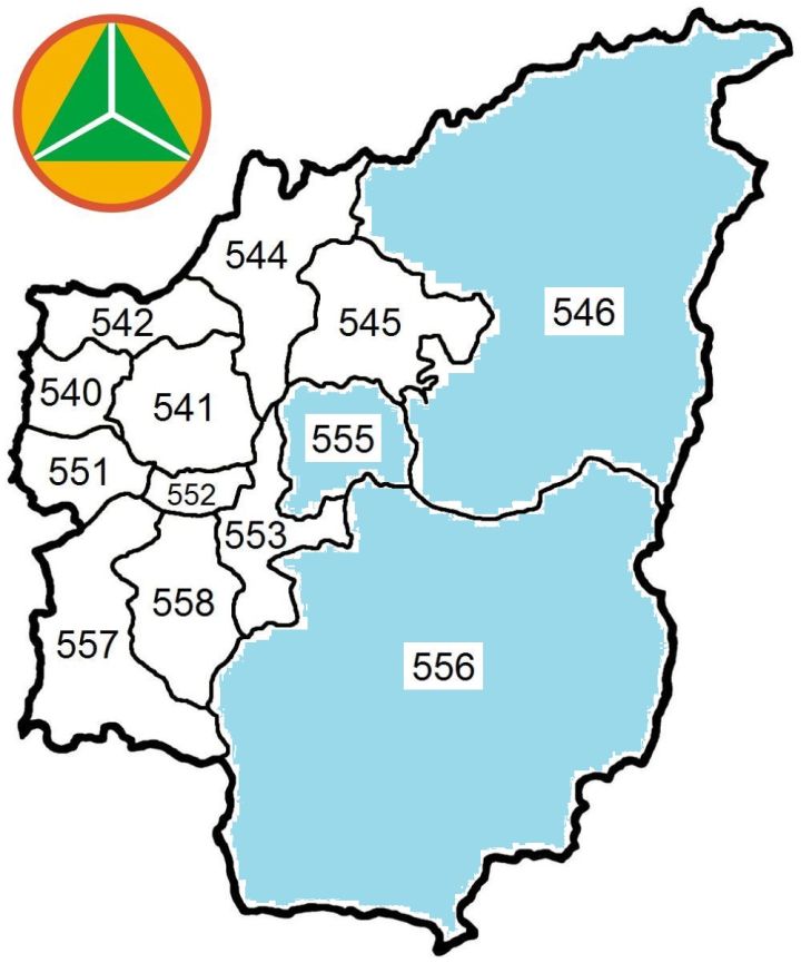
TOP HOME [◆ Counties] [Nantou County]
Legislative representation
COMPOSITION OF ELECTORAL DISTRICTS FOR THE ROC LEGISLATIVE YUAN
| District No. | Covered cities, townships |
|---|---|
| # 1 | Caotun, Guoxing, Puli, Ren'ai, Yuchi, Zhongliao |
| # 2 | Jiji, Lugu, Mingjian, Nantou, Shuili, Xinyi, Zhushan |
LEGISLATIVE REPRESENTATION SINCE 2008—(By-elections not included)
| # | Winner 2008 | Winner 2012 | Winner 2016 | Winner 2020 | Winner 2024 |
|---|---|---|---|---|---|
| 1 | Wu Den-yih, KMT | ||||
| 2 | Yu Hao, KMT | ||||
For detailed information about legislative representation in the ROC go to the page Legislative Yuan (Parliament).
TOP HOME [◆ Counties] [Nantou County]
Additional information about Nantou county
PROTECTED AREAS IN THE COUNTY—[part of] Yushan National Park 玉山國家公園; [part of] Taroko National Park 太魯閣國家公園; [part of] Mt. Chiu-chiu Nature Reserve 九九峰自然保留區; [part of] Danda Major Wildlife Habitat 丹大野生動物重要棲息環境; Rueiyan River Major Wildlife Habitat 瑞岩溪野生動物重要棲息環境
SELECTED SIGHTS—Sun Moon Lake 日月潭, Formosan Aboriginal Culture Village 九族文化村, Geographic Center of Taiwan 台灣地理中心碑, Paper Dome 紙教堂, Chung Tai Chan Monastery 中台禪寺, Wushe Incident Memorial Park 霧社事件紀念公園, Cingjing Farm 清境農場, Fonghuanggu Bird and Ecology Park 鳳凰谷鳥園生態園區, Xitou Forest Recreation Area 溪頭森林遊樂區/Xitou Nature Education Area 溪頭自然教育園區, Hehuan Mountain Dark Sky Park 合歡山暗空公園
SEISMIC ACTIVITY—Although the area most earthquake-prone in Taiwan is the east coast (Hualien County, Taitung County and Yilan County), the deadliest temblor to hit Taiwan since WWII occurred in Nantou County on Sept. 21, 1999, dubbed jiu er yi da dizhen 九二一大地震 in Chinese. The table directly below is an excerpt of a list showing all major earthquakes in the Taiwan area since 1945 and presents major quakes with epicenter in Nantou county.
| Year | Date | Magnitude | Depth | Fatalities | Location of epicenter | Coordinates |
|---|---|---|---|---|---|---|
| 1999 | Sept. 21 | 7.3 | 8.0 km | 2,415 | Jiji 552 ℹ ℹ | 120.82° E, 23.85° N |
| Sept. 26 | 6.8 | 12.1 km | 7 | Ren'ai 546 ℹ | 121.00° E, 23.85° N | |
| 2000 | May 17 | 5.6 | 9.7 km | 3 | Ren'ai 546 ℹ ℹ | 121.10° E, 24.19° N |
| June 11 | 6.7 | 16.2 km | 2 | Ren'ai 546 ℹ ℹ | 121.11° E, 23.90° N | |
| 2009 | Nov. 5 | 6.2 | 24.1 km | — | Zhushan 557 ℹ ℹ | 120.72° E, 23.79° N |
| 2013 | March 27 | 6.2 | 19.4 km | 1 | Ren'ai 546 ℹ ℹ | 121.05° E, 23.90° N |
| June 2 | 6.5 | 14.5 km | 4 | Yuchi 555 ℹ ℹ | 120.97° E, 23.86° N |
Please note that the number of casualties resulting from the 1999 temblor includes fatalities reported in all of Taiwan proper.
TOP HOME [◆ Counties] [Nantou County]
Yunlin County
- Area and population
- County administration
- Legislative representation
- Additional information about Yunlin county
+++++ ⤒ 🏠 [next entity] [previous entity] +++++
| ✉ Yunlin County Government 雲林縣 縣政府 | |
| No. 515 Yunlin Road Sec. 2, Douliou City, Yunlin County 64001, Taiwan ROC [64001 雲林縣斗六市雲林路 2 段 515 號] ———————————— 🌏 Yunlin County Government – Web link |
 |
| Alternative logo |  |
Area and population
AREA—1,290.8326 km² (no indigenous communities). According to Google Earth, the county limits are located between latitude 23° 18' 00"–23° 30' 30" N and longitude 120° 04' 48"–120° 26' 24" E.
Adjacent counties/cities: Changhua County, Nantou County, Chiayi County
POPULATION DEVELOPMENT SINCE 1974—(figures for the end of the year)
| Year | Inhabitants | Year | Inhabitants | Year | Inhabitants | Year | Inhabitants | |||
|---|---|---|---|---|---|---|---|---|---|---|
| 1974 | 799,766 | 1987 | 775,588 | 2000 | 743,368 | 2013 | 707,792 | |||
| 1975 | 801,422 | 1988 | 765,443 | 2001 | 743,562 | 2014 | 705,356 | |||
| 1976 | 803,739 | 1989 | 757,198 | 2002 | 742,797 | 2015 | 699,633 | |||
| 1977 | 804,295 | 1990 | 753,639 | 2003 | 740,501 | 2016 | 694,873 | |||
| 1978 | 800,988 | 1991 | 753,710 | 2004 | 736,772 | 2017 | 690,373 | |||
| 1979 | 799,023 | 1992 | 753,841 | 2005 | 733,330 | 2018 | 686,022 | |||
| 1980 | 796,276 | 1993 | 755,753 | 2006 | 728,490 | 2019 | 681,306 | |||
| 1981 | 796,968 | 1994 | 753,791 | 2007 | 725,672 | 2020 | 676,873 | |||
| 1982 | 797,849 | 1995 | 753,998 | 2008 | 723,674 | 2021 | 670,132 | |||
| 1983 | 796,751 | 1996 | 752,427 | 2009 | 722,795 | 2022 | 664,092 | |||
| 1984 | 795,258 | 1997 | 751,913 | 2010 | 717,653 | 2023 | 659,468 | |||
| 1985 | 791,186 | 1998 | 748,995 | 2011 | 713,556 | 2024 | 658,427 | |||
| 1986 | 783,526 | 1999 | 746,241 | 2012 | 710,991 | 2025 | 650,989 |
General population statistics about Taiwan / the ROC can be found here.
TOP HOME [◆ Counties] [Yunlin County]
County administration
● Yunlin county magistrates since 1989
| Tenure | Name | Born/Died | Political Affiliation |
|---|---|---|---|
| 12/1989—12/1997 | Liao Chuan-yu 廖泉裕 | b. 1938 | KMT |
| 12/1997—8/1999 † | Su Wen-hsiung 蘇文雄 | 1943-1999 | KMT |
| 8/1999—11/1999 @ | Li Hsueh-tsung 李學聰 | N/A | KMT |
| 11/1999—12/2005 | Chang Jung-wei 張榮味 | b. 1946 | KMT |
| 3/2005—12/2005 @ | John C. Y. Lee 李進勇 | b. 1951 | DPP |
| 12/2005—12/2014 | Su Chih-fen 蘇治芬 | b. 1953 | DPP |
| 12/2014—12/2018 | John C. Y. Lee (second time) | ||
| 12/2018— | Chang Li-shan 張麗善 | b. 1964 | KMT |
Note: Chang Jung-wei was sentenced by the Yunlin District Court on Oct. 28, 2005 to 14 years imprisonment for graft in connection with an incinerator project in Linnei Township. He was found not guilty in a second trial, a ruling that was later reversed. The corruption case kept the Taiwan High Court Tainan Branch and the ROC Supreme Court busy for years, but on July 4, 2018 the Supreme Court eventually rejected an appeal by Chang and sentenced him to 8 years imprisonment in a final verdict.
Su Chih-fen was detained and questioned on Nov. 4, 2008 on corruption charges in connection with a landfill construction project and indicted on Nov. 14, 2008. The Yunlin District Court acquitted her on April 29, 2011, a verdict upheld by the Taiwan High Court Tainan Branch on Aug. 31, 2012. The ROC Supreme Court remanded a prosecutorial appeal and closed the case on Jan. 10, 2013.
● Administrative division
1 city, 5 urban townships, 14 rural townships:
| Baozhong Township 褒忠鄉 634 ⒭ Beigang Township 北港鎮 651 ⒰ Citong Township 莿桐鄉 647 ⒭ Dapi Township 大埤鄉 631 ⒭ Dongshi Township 東勢鄉 635 ⒭ Douliu City 斗六市 640 Dounan Township 斗南鎮 630 ⒰ Erlun Township 二崙鄉 649 ⒭ Gukeng Township 古坑鄉 646 ⒭ Huwei Township 虎尾鎮 632 ⒰ |
Kouhu Township 口湖鄉 653 ⒭ Linnei Township 林內鄉 643 ⒭ Lunbei Township 崙背鄉 637 ⒭ Mailiao Township 麥寮鄉 638 ⒭ Shuilin Township 水林鄉 652 ⒭ Sihu Township 四湖鄉 654 ⒭ Taixi Township 台西鄉 636 ⒭ Tuku Township 土庫鎮 633 ⒰ Xiluo Township 西螺鎮 648 ⒰ Yuanchang Township 元長鄉 655 ⒭ |
 |
 |
Yunlin County has no indigenous communities. |
TOP HOME [◆ Counties] [Yunlin County]
Legislative representation
COMPOSITION OF ELECTORAL DISTRICTS FOR THE ROC LEGISLATIVE YUAN
| District No. | Covered cities, townships |
|---|---|
| # 1 | Baozhong, Beigang, Dongshi, Huwei, Kouhu, Mailiao, Shuilin, Sihu, Taixi, Tuku, Yuanchang |
| # 2 | Citong, Dapi, Douliu, Dounan, Erlun, Gukeng, Linnei, Lunbei, Xiluo |
LEGISLATIVE REPRESENTATION SINCE 2008—(By-elections not included)
| # | Winner 2008 | Winner 2012 | Winner 2016 | Winner 2020 | Winner 2024 |
|---|---|---|---|---|---|
| 1 | Ting Hsueh-chung, KMT | ||||
| 2 | Chang Sho-wen, KMT | ||||
For detailed information about legislative representation in the ROC go to the page Legislative Yuan (Parliament).
TOP HOME [◆ Counties] [Yunlin County]
Additional information about Yunlin county
PROTECTED AREAS IN THE COUNTY—Yunlin Huben Fairy Pitta Wildlife Habitat 雲林湖本八色鳥野生動物重要棲息環境; [part of] Jhangyunjia Coastal Protection Area 彰雲嘉沿海保護區
SELECTED SIGHTS—Caoling 草嶺, Chaotian Temple 北港朝天宫, Penglai Waterfall 蓬萊瀑布, Yunlin Story House 雲林故事館, Yunlin Hand Puppet Museum 雲林布袋戲館
TOP HOME [◆ Counties] [Yunlin County]
Chiayi County
- Area and population
- County administration
- Legislative representation
- Additional information about Chiayi county
+++++ ⤒ 🏠 [next entity] [previous entity] +++++
| ✉ Chiayi County Government 嘉義縣 縣政府 | |
| No. 1 Sianghe 1st Road, East Section, Sianghe Sincun, Taibao City, Chiayi County 61249, Taiwan ROC [61249 嘉義縣太保市祥和新村祥和一路東段 1 號] ———————————— 🌏 Chiayi County Government – Web link |
 |
(Jump to Chiayi City) (Chiayi before 1982)
Area and population
AREA—1,903.6367 km², including 427.8471 km² indigenous communities (22.475 percent of Chiayi County's area). Click here to see a map showing the indigenous communities in the county highlighted with torquoise colour. According to Google Earth, the county limits are located between latitude 23° 07' 12"–23° 22' 12" N and longitude 120° 04' 12"–120° 34' 12" E. The Tropic of Cancer 北回歸線 (latitude 23° 26' 13.8" N) crosses Chiayi County.
Adjacent counties/cities: Nantou County, Yunlin County, Chiayi City, Tainan City, Kaohsiung City
POPULATION DEVELOPMENT SINCE 1982—(figures for the end of the year)
| Year | Inhabitants | Year | Inhabitants | Year | Inhabitants | Year | Inhabitants | |||
|---|---|---|---|---|---|---|---|---|---|---|
| 1981 | N/A | 1993 | 562,897 | 2005 | 557,101 | 2017 | 511,182 | |||
| 1982 | 574,702 | 1994 | 564,381 | 2006 | 553,841 | 2018 | 507,068 | |||
| 1983 | 574,712 | 1995 | 565,804 | 2007 | 551,345 | 2019 | 503,113 | |||
| 1984 | 573,159 | 1996 | 565,700 | 2008 | 548,731 | 2020 | 499,481 | |||
| 1985 | 569,932 | 1997 | 567,695 | 2009 | 547,716 | 2021 | 493,316 | |||
| 1986 | 564,338 | 1998 | 565,733 | 2010 | 543,248 | 2022 | 488,158 | |||
| 1974 | 558,896 | 1999 | 562,662 | 2011 | 537,942 | 2023 | 484,560 | |||
| 1988 | 554,537 | 2000 | 562,305 | 2012 | 533,723 | 2024 | 478,786 | |||
| 1989 | 552,000 | 2001 | 563,365 | 2013 | 529,229 | 2025 | 473,181 | |||
| 1990 | 552,277 | 2002 | 562,394 | 2014 | 524,783 | |||||
| 1991 | 554,746 | 2003 | 560,410 | 2015 | 519,839 | |||||
| 1992 | 556,580 | 2004 | 557,903 | 2016 | 515,320 | |||||
Please note that before July 1, 1982 Chiayi county included Chiayi city, therefore separate figures for Chiayi county and Chiayi city are available beginning 1982 only. (See additional remarks below.)
Major indigenous peoples: Tsou (see also The indigenous peoples in contemporary Taiwan)
General population statistics about Taiwan / the ROC can be found here.
TOP HOME [◆ Counties] [Chiayi County]
County administration
● Chiayi county magistrates since 1989
| Tenure | Name | Born/Died | Political Affiliation |
|---|---|---|---|
| 12/1989—12/1993 | Ho Chia-jong 何嘉榮 | b. 1945 | KMT |
| 12/1993—12/1997 | Chen Shih-yung 陳適庸 | b. 1948 | KMT |
| 12/1997—12/2001 | Lee Ya-ching 李雅景 | b. 1949 | KMT |
| 12/2001—12/2009 | Chen Ming-wen 陳明文 | b. 1954 | DPP |
| 12/2009—12/2018 | Helen Chang Hwa-kuan 張花冠 | b. 1954 | DPP |
| 12/2018— | Weng Chang-liang 翁章梁 | b. 1965 | DPP |
● Administrative division
2 cities, 2 urban townships, 14 rural townships, including 1 Mountain Aborigines community
(Ⓜ):
| Alishan Township 阿里山鄉 605 ⒭ Ⓜ Budai Township 布袋鎮 625 ⒰ Dalin Township 大林鎮 622 ⒰ Dapu Township 大埔鄉 607 ⒭ Dongshi Township 東石鄉 614 ⒭ Fanlu Township 番路鄉 602 ⒭ Liujiao Township 六腳鄉 615 ⒭ Lucao Township 鹿草鄉 611 ⒭ Meishan Township 梅山鄉 603 ⒭ |
Minxiong Township 民雄鄉 621 ⒭ Puzi City 朴子市 613 Shuishang Township 水上鄉 608 ⒭ Taibao City 太保市 612 Xikou Township 溪口鄉 623 ⒭ Xingang Township 新港鄉 616 ⒭ Yizhu Township 義竹鄉 624 ⒭ Zhongpu Township 中埔鄉 606 ⒭ Zhuqi Township 竹崎鄉 604 ⒭ |
 |  | For a map which highlights the indigenous communities in Chiayi County in turquoise colour please click here. |
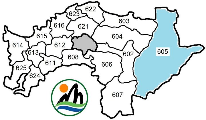
TOP HOME [◆ Counties] [Chiayi County]
Legislative representation
COMPOSITION OF ELECTORAL DISTRICTS FOR THE ROC LEGISLATIVE YUAN
| District No. | Covered cities, townships |
|---|---|
| # 1 | Budai, Dongshi, Liujiao, Lucao, Puzi, Shuishang, Taibao, Yizhu |
| # 2 | Alishan, Dalin, Dapu, Fanlu, Meishan, Minxiong, Xikou, Xingang, Zhongpu, Zhuqi |
LEGISLATIVE REPRESENTATION SINCE 2008—(By-elections not included)
| # | Winner 2008 | Winner 2012 | Winner 2016 | Winner 2020 | Winner 2024 |
|---|---|---|---|---|---|
| 1 | |||||
| 2 | Chang Hwa-kuan, DPP | Chen Kuan-ting, DPP | |||
For detailed information about legislative representation in the ROC go to the page Legislative Yuan (Parliament).
TOP HOME [◆ Counties] [Chiayi County]
Additional information about Chiayi county
PROTECTED AREAS IN THE COUNTY—[part of] Yushan National Park 玉山國家公園; Alishan Taiwan Pleione Nature Reserve 阿里山台灣一葉蘭自然保留區; Lulinshan Major Wildlife Habitat 鹿林山野生動物重要棲息環境; Tashan Major Wildlife Habitat 塔山野生動物重要棲息環境; Aogu Major Wildlife Habitat 鰲鼓野生動物重要棲息環境; [part of] Jhangyunjia Coastal Protection Area 彰雲嘉沿海保護區; Haomeiliao Coastal Protection Area 好美寮沿海保護區
SELECTED SIGHTS—Alishan 阿里山, Siraya National Scenic Area 西拉雅國家風景區, Tropic of Cancer Monument 嘉義北回歸線標誌, National Palace Museum Southern Branch 國立故宮博物院南部分院, Ping Huang Coffee Museum 品皇咖啡博物館
SEISMIC ACTIVITY—The table directly below is an excerpt of a list showing all major earthquakes in the Taiwan area since 1945 and presents major quakes with epicenter in Chiayi county.
| Year | Date | Magnitude | Depth | Fatalities | Location of epicenter | Coordinates |
|---|---|---|---|---|---|---|
| 1998 | July 17 | 6.2 | 2.8 km | 5 | Zhuqi 604 ℹ | 120.66° E, 23.50° N |
| 1999 | Oct. 22 | 6.4 | 16.6 km | — | Minxiong 621 ℹ | 120.42° E, 23.52° N |
| 2025 | Jan. 21 | 6.4 | 9.7 km | — | Dapu 607 ℹ ℹ | 120.57° E, 23.23° N |
SPECIAL PROJECT—On Aug. 13, 2022 the government-run Asia UAV AI Innovation Application R&D Center (Yazhou wurenji AI chuangxin yingyong yanfa zhongxin 亞洲無人機AI創新應用研發中心, abbrev. yachuang zhongxin 亞創中心) was opened by ROC President Tsai Ing-wen in Chiayi county's Puzi City, with the Civil Aeronautics Administration under MOTC and the National Chung-Shan Institute of Science and Technology (NCSIST) providing assistance and cooperation.
TOP HOME [◆ Counties] [Chiayi County]
Pingtung County
- Area and population
- County administration
- Legislative representation
- Additional information about Pingtung county
+++++ ⤒ 🏠 [next entity] [previous entity] +++++
| ✉ Pingtung County Government 屏東縣 縣政府 | |
| No. 527 Tzu-yu Road, Pingtung City, Pingtung County 90001, Taiwan ROC [90001 屏東縣屏東市自由路 527 號] ———————————— 🌏 Pingtung County Government – Web link |
 |
Area and population
AREA—2,775.6003 km², including 1,625.3362 km² indigenous communities (58.558 percent of Pingtung County's area). Click here to see a map showing the indigenous communities in the county highlighted with torquoise colour. According to Google Earth, the county limits are located between latitude 21° 31' 48"–22° 31' 12" N and longitude 120° 12' 36"–120° 32' 24" E.
Adjacent counties/cities: Kaohsiung City, Taitung County
POPULATION DEVELOPMENT SINCE 1974—(figures for the end of the year)
| Year | Inhabitants | Year | Inhabitants | Year | Inhabitants | Year | Inhabitants | |||
|---|---|---|---|---|---|---|---|---|---|---|
| 1974 | 850,013 | 1987 | 894,652 | 2000 | 907,590 | 2013 | 852,286 | |||
| 1975 | 857,089 | 1988 | 892,057 | 2001 | 909,364 | 2014 | 847,917 | |||
| 1976 | 867,404 | 1989 | 889,552 | 2002 | 906,178 | 2015 | 841,253 | |||
| 1977 | 873,929 | 1990 | 893,282 | 2003 | 903,772 | 2016 | 835,792 | |||
| 1978 | 879,128 | 1991 | 897,176 | 2004 | 900,199 | 2017 | 829,939 | |||
| 1979 | 884,311 | 1992 | 901,491 | 2005 | 898,300 | 2018 | 825,406 | |||
| 1980 | 888,270 | 1993 | 906,428 | 2006 | 893,544 | 2019 | 819,184 | |||
| 1981 | 892,107 | 1994 | 909,110 | 2007 | 889,563 | 2020 | 812,658 | |||
| 1982 | 896,966 | 1995 | 911,843 | 2008 | 884,838 | 2021 | 804,440 | |||
| 1983 | 900,614 | 1996 | 912,850 | 2009 | 882,640 | 2022 | 798,703 | |||
| 1984 | 902,210 | 1997 | 913,764 | 2010 | 873,509 | 2023 | 794,997 | |||
| 1985 | 901,981 | 1998 | 910,540 | 2011 | 864,529 | 2024 | 789,239 | |||
| 1986 | 897,714 | 1999 | 909,015 | 2012 | 858,441 | 2025 | 782,256 |
Major indigenous peoples: Amis, Paiwan, Rukai (see also The indigenous peoples in contemporary Taiwan)
General population statistics about Taiwan / the ROC can be found here.
TOP HOME [◆ Counties] [Pingtung County]
County administration
● Pingtung county magistrates since 1989
| Tenure | Name | Born/Died | Political Affiliation |
|---|---|---|---|
| 12/1989—12/1993 | Su Tseng-chang 蘇貞昌 | b. 1947 | DPP |
| 12/1993—12/1997 | Wu Jzer-yuan 伍澤元 | 1945-2008 | KMT |
| 12/1997—4/2004 | Su Jia-chyuan 蘇嘉全 | b. 1956 | DPP |
| 4/2004—12/2005 @ | Wu Ying-wen 吳應文 | b. 1949 | DPP |
| 12/2005—12/2014 | Charles Tsao 曹啟鴻 | b. 1948 | DPP |
| 12/2014—12/2022 | Pan Meng-an 潘孟安 | b. 1963 | DPP |
| 12/2022— | Chou Chun-mi 周春米 | b. 1966 | DPP |
● Administrative division
1 city, 3 urban townships, 29 rural townships, including 8 Mountain Aborigines communities
(Ⓜ) and 1 Plains Aborigines community (Ⓟ):
| Changzhi Township 長治鄉 908 ⒭ Chaozhou Township 潮州鎮 920 ⒰ Checheng Township 車城鄉 944 ⒭ Chunri Township 春日鄉 942 ⒭ Ⓜ Donggang Township 東港鎮 928 ⒰ Fangliao Township 枋寮鄉 940 ⒭ Fangshan Township 枋山鄉 941 ⒭ Gaoshu Township 高樹鄉 906 ⒭ Hengchun Township 恆春鎮 946 ⒰ Jiadong Township 佳冬鄉 931 ⒭ Jiuru Township 九如鄉 904 ⒭ Kanding Township 崁頂鄉 924 ⒭ Laiyi Township 來義鄉 922 ⒭ Ⓜ Ligang Township 里港鄉 905 ⒭ Linbian Township 林邊鄉 927 ⒭ Linluo Township 麟洛鄉 909 ⒭ Liuqiu Township 琉球鄉 929 ⒭ |
Majia Township 瑪家鄉 903 ⒭ Ⓜ Manzhou Township 滿州鄉 947 ⒭ Ⓟ Mudan Township 牡丹鄉 945 ⒭ Ⓜ Nanzhou Township 南州鄉 926 ⒭ Neipu Township 內埔鄉 912 ⒭ Pingtung City 屏東市 900 Sandimen Township 三地門鄉 901 ⒭ Ⓜ Shizi Township 獅子鄉 943 ⒭ Ⓜ Taiwu Township 泰武鄉 921 ⒭ Ⓜ Wandan Township 萬丹鄉 913 ⒭ Wanluan Township 萬巒鄉 923 ⒭ Wutai Township 霧台鄉 902 ⒭ Ⓜ Xinpi Township 新埤鄉 925 ⒭ Xinyuan Township 新園鄉 932 ⒭ Yanpu Township 鹽埔鄉 907 ⒭ Zhutian Township 竹田鄉 911 ⒭ |
 |  | For a map which highlights the indigenous communities in Pingtung County in turquoise colour please click here. |
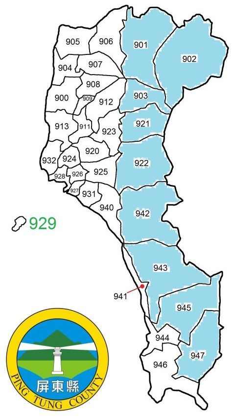
Liuqiu Township (929) is the offshore Liuchiu Island (liuqiu yu 琉球嶼) aka Siaoliouciou (xiaoliuqiu 小琉球)/Lamay Island/Lambai Island/Gold Lion Island.
TOP HOME [◆ Counties] [Pingtung County]
Legislative representation
COMPOSITION OF ELECTORAL DISTRICTS FOR THE ROC LEGISLATIVE YUAN
| District No. | Covered cities, townships |
|---|---|
| # 1 | Changzhi, Chaozhou, Gaoshu, Jiuru, Ligang, Majia, Neipu, Sandimen, Taiwu, Wanluan, Wutai, Yanpu, Zhutian |
| # 2 | Linluo, Pingtung, Wandan |
| # 3 | Checheng, Chunri, Donggang, Fangliao, Fangshan, Hengchun, Jiadong, Kanding, Laiyi, Linbian, Liuqiu, Manzhou, Mudan, Nanzhou, Shizi, Xinpi, Xinyuan |
On Jan. 11, 2019 the CEC announced a redrawing of legislative districts, cutting one seat from Pingtung county. An overview of changed electoral districts is shown below:
| District No. | Old composition | New composition |
|---|---|---|
| Pingtung 1 | Changzhi, Chaozhou, Gaoshu, Jiuru, Ligang, Majia, Neipu, Sandimen, Taiwu, Wanluan, Wutai, Yanpu, Zhutian | Changzhi, Gaoshu, Jiuru, Ligang, Linluo, Majia, Neipu, Sandimen, Wutai, Yanpu as well as Pingtung City; the remainder of the county was drawn into Pingtung County's 2nd electoral district |
| Pingtung 2 | Linluo, Pingtung, Wandan | Chaozhou, Checheng, Chunri, Donggang, Fangliao, Fangshan, Hengchun, Jiadong, Kanding, Laiyi, Linbian, Liuqiu, Manzhou, Mudan, Nanzhou, Shizi, Taiwu, Wandan, Wanluan, Xinpi, Xinyuan, Zhutian |
| Pingtung 3 | Checheng, Chunri, Donggang, Fangliao, Fangshan, Hengchun, Jiadong, Kanding, Laiyi, Linbian, Liuqiu, Manzhou, Mudan, Nanzhou, Shizi, Xinpi, Xinyuan | <Abolished> |
LEGISLATIVE REPRESENTATION SINCE 2008—(By-elections not included)
| # | Winner 2008 | Winner 2012 | Winner 2016 | Winner 2020 | Winner 2024 |
|---|---|---|---|---|---|
| 1 | |||||
| 2 | Chung Chia-pin, DPP | Su Chen-ching, DPP | Hsu Fu-kuei, DPP | ||
| 3 | Chuang Ruei-hsiung, DPP | ||||
For detailed information about legislative representation in the ROC go to the page Legislative Yuan (Parliament).
TOP HOME [◆ Counties] [Pingtung County]
Additional information about Pingtung county
PROTECTED AREAS IN THE COUNTY—Kenting National Park 墾丁國家公園; Kenting Barrier Reefs Mountain Nature Reserve 墾丁高位珊瑚礁自然保留區; Xuhai Guanyinbi Nature Reserve 旭海觀音鼻自然保留區; Jinshueiying Major Wildlife Habitat 浸水營野生動物重要棲息環境; Chachayalaishan Major Wildlife Habitat 茶茶牙賴山野生動物重要棲息環境; [part of] Shuangguei Lake Major Wildlife Habitat 雙鬼湖野生動物重要棲息環境; Jianshan Coastal Protection Area 尖山沿海保護區; Kenting Coastal Protection Area 墾丁沿海保護區; Jioupeng Coastal Protection Area 九棚沿海保護區
SELECTED SIGHTS—Kenting National Park 墾丁國家公園, South Bay 南灣, Sandimen 三地門, Eluanbi Lighthouse 鵝鑾鼻燈塔 near the island's southernmost point, Siaoliouciou 小琉球, Wandan Mud Volcano 萬丹泥火山, Liudui Hakka Cultural Park 六堆客家文化園區, Neipu Tianhou Temple 內埔鄉天后宮, National Museum of Marine Biology and Aquarium 國立海洋生物博物館
SEISMIC ACTIVITY—The table directly below is an excerpt of a list showing all major earthquakes in the Taiwan area since 1945 and presents major quakes with epicenter in and off Pingtung county.
| Year | Date | Magnitude | Depth | Fatalities | Location of epicenter | Coordinates |
|---|---|---|---|---|---|---|
| 1955 | April 4 | 6.5 | 5 km | — | ~ 11.5 km off Hengchun 946 ℹ | 120.9° E, 21.8° N |
| 1959 | Aug. 15 | 7.1 | 20 km | 16 | ~ 50.1 km off Hengchun 946 ℹ | 121.3° E, 21.7° N |
| 2006 | Dec. 26 | 7.0 | 44.1 km | 2 | ~ 30.7 km off Hengchun 946 ℹ ℹ | 120.56° E, 21.69° N |
| " | 7.0 | 50.2 km | — | ~ 28.2 km off Hengchun 946 ℹ ℹ | 120.42° E, 21.97° N | |
| 2012 | Feb. 26 | 6.4 | 26.3 km | — | Wutai 902 ℹ ℹ | 120.75° E, 22.75° N |
TOP HOME [◆ Counties] [Pingtung County]
Yilan County
- Area and population
- County administration
- Legislative representation
- Additional information about Yilan county
- Disputed outpost
+++++ ⤒ 🏠 [next entity] [previous entity] +++++
| ✉ Yilan County Government 宜蘭縣 縣政府 | |
| No. 1 Sianjheng North Road, Yilan City, Yilan County 26060, Taiwan ROC [26060 宜蘭縣宜蘭市凱旋里三鄰縣政北路 1 號] ———————————— 🌏 Yilan County Government – Web link |
 |
Note: In older sources, Yilan is often spelled "Ilan". Details about the Diaoyutai Islands 釣魚臺列嶼 can be found here.
Area and population
AREA—2,143.6251 km², including 1,398.1962 km² indigenous communities (65.225 percent of Yilan County's area). Click here to see a map showing the indigenous communities in the county highlighted with torquoise colour. According to Google Earth, the county limits are located between latitude 24° 10' 48"–24° 35' 24" N and longitude 121° 11' 24"–121° 34' 48" E.
Adjacent counties/cities: New Taipei City, Taoyuan City, Hsinchu County, Taichung City, Hualien County
POPULATION DEVELOPMENT SINCE 1974—(figures for the end of the year)
| Year | Inhabitants | Year | Inhabitants | Year | Inhabitants | Year | Inhabitants | |||
|---|---|---|---|---|---|---|---|---|---|---|
| 1974 | 424,689 | 1987 | 447,467 | 2000 | 465,186 | 2013 | 458,456 | |||
| 1975 | 427,655 | 1988 | 447,643 | 2001 | 465,799 | 2014 | 458,777 | |||
| 1976 | 431,291 | 1989 | 448,430 | 2002 | 464,107 | 2015 | 458,117 | |||
| 1977 | 435,184 | 1990 | 450,943 | 2003 | 463,285 | 2016 | 457,538 | |||
| 1978 | 438,004 | 1991 | 453,765 | 2004 | 462,286 | 2017 | 456,607 | |||
| 1979 | 440,366 | 1992 | 456,857 | 2005 | 461,586 | 2018 | 455,221 | |||
| 1980 | 442,988 | 1993 | 462,509 | 2006 | 460,426 | 2019 | 454,178 | |||
| 1981 | 445,472 | 1994 | 464,359 | 2007 | 460,398 | 2020 | 453,087 | |||
| 1982 | 447,105 | 1995 | 465,043 | 2008 | 460,902 | 2021 | 450,692 | |||
| 1983 | 447,707 | 1996 | 465,120 | 2009 | 461,625 | 2022 | 449,062 | |||
| 1984 | 449,833 | 1997 | 466,603 | 2010 | 458,456 | 2023 | 449,890 | |||
| 1985 | 449,981 | 1998 | 465,627 | 2011 | 458,777 | 2024 | 449,212 | |||
| 1986 | 448,418 | 1999 | 465,004 | 2012 | 458,117 | 2025 | 449,336 |
Major indigenous peoples: Atayal, Kavalan (see also The indigenous peoples in contemporary Taiwan)
General population statistics about Taiwan / the ROC can be found here.
TOP HOME [◆ Counties] [Yilan County]
County administration
● Yilan county magistrates since 1989
| Tenure | Name | Born/Died | Political Affiliation |
|---|---|---|---|
| 12/1989—12/1997 | Yu Shyi-kun 游錫堃 | b. 1948 | DPP |
| 12/1997—12/2005 | Liu Shou-cheng 劉守成 | b. 1951 | DPP |
| 12/2005—12/2009 | Lu Kuo-hua 呂國華 | b. 1956 | KMT |
| 12/2009—2/2017 | Lin Tsong-shyan 林聰賢 | b. 1962 | DPP |
| 2/2017—11/2017 @ | Wu Tse-cheng 吳澤成 | b. 1945 | N/A |
| 11/2017—12/2018 @ | Chen Chin-te 陳金德 | b. 1961 | DPP |
| 12/2018— | Lin Tzu-miao 林姿妙 | b. 1952 | KMT |
| 12/2024— @ | Lin Mao-sheng 林茂盛 | b. 1967 | Ind. |
Lin Tzu-miao was suspended from office on Dec. 31, 2024 when the Yilan District Court found her guilty of corruption, sentencing her to 12 years and six months in prison. As the verdict can still be appealed, the case is ongoing.
● Administrative division
1 city, 3 urban townships, 8 rural townships, including 2 Mountain Aborigines communities
(Ⓜ):
| Datong Township 大同鄉 267 ⒭ Ⓜ Dongshan Township 冬山鄉 269 ⒭ Jiaoxi Township 礁溪鄉 262 ⒭ Luodong Township 羅東鎮 265 ⒰ Nan'ao Township 南澳鄉 272 ⒭ Ⓜ Sanxing Township 三星鄉 266 ⒭ Su'ao Township 蘇澳鎮 270 ⒰ |
Toucheng Township 頭城鎮 261 ⒰ [including Guishan Island 龜山島] Wujie Township 五結鄉 268 ⒭ Yilan City 宜蘭市 260 Yuanshan Township 員山鄉 264 ⒭ Zhuangwei Township 壯圍鄉 263 ⒭ |
 |  | For a map which highlights the indigenous communities in Yilan County in turquoise colour please click here. |
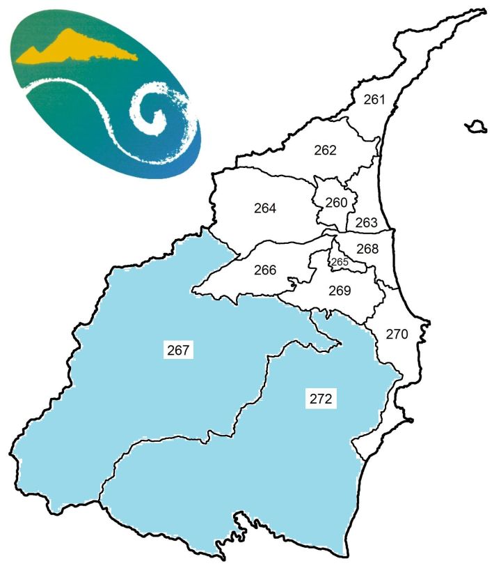
TOP HOME [◆ Counties] [Yilan County]
Legislative representation
ELECTORAL DISTRICTS FOR THE ROC LEGISLATIVE YUAN—Since 2008 Yilan County as a whole has been represented in the ROC Legislative Yuan by one electoral district only. The table below shows the legislative representation since 2008 (By-elections not included).
| Winner 2008 | Winner 2012 | Winner 2016 | Winner 2020 | Winner 2024 |
|---|---|---|---|---|
| Lin Chien-jung, KMT | Chen Chun-yu, DPP | |||
For detailed information about legislative representation in the ROC go to the page Legislative Yuan (Parliament).
TOP HOME [◆ Counties] [Yilan County]
Additional information about Yilan county
PROTECTED AREAS IN THE COUNTY—[part of] Hapen Nature Reserve 哈盆自然保留區; [part of] Yuanyang Lake Nature Reserve 鴛鴦湖自然保留區; Nanao Broad-leaved Forest Nature Reserve 南澳闊葉樹林自然保留區; Wushihbi Coastal Nature Reserve 烏石鼻海岸自然保留區; Yilan County Wuweigang Waterbird Refuge 宜蘭縣無尾港水鳥保護區; Lanyang Estuary Waterbird Refuge 蘭陽溪口水鳥保護區; Shuanglianpi Wildlife Refuge 雙連埤野生動物保護區; Lanyang Estuary Major Wildlife Habitat 蘭陽溪口野生動物重要棲息環境; Wuweigang Major Wildlife Habitat 無尾港野生動物重要棲息環境; [part of] Cilan (or Chilan) Major Wildlife Habitat 棲蘭野生動物重要棲息環境; Guanyin Coast Major Wildlife Habitat 觀音海岸野生動物重要棲息環境; Shuanglianpi Major Wildlife Habitat 雙連埤野生動物重要棲息環境; [part of] Northeast Coastal Protection Area 東北角沿海保護區; Lanyang Coastal Protection Area 蘭陽海岸保護區; [part of] Suhua Coastal Protection Area 蘇花海岸保護區
SELECTED SIGHTS—Chiaohsi Hot Springs 礁溪溫泉, Luodong Night Market 羅東夜市, Taiping Mountain Forest Amusement Park 太平山國家森林遊樂區, Guishan Island 龜山島, National Center of Traditional Arts 國立傳統藝術中心, Lanyang Museum 蘭陽博物館
SEISMIC ACTIVITY—Yilan County can be considered Taiwan's No. 3 earthquake hotspot behind Hualien County and Taitung County. The table directly below is an excerpt of a list showing all major earthquakes in the Taiwan area since 1945 and presents major quakes with epicenter in or off Yilan county.
| Year | Date | Magnitude | Depth | Fatalities | Location of epicenter | Coordinates |
|---|---|---|---|---|---|---|
| 1963 | Feb. 13 | 7.4 | 47 km | 3 | ~ 25.8 km off Su'ao 270 ℹ | 122.1° E, 24.4° N |
| March 4 | 5.9 | 5 km | 1 | Su'ao 270 ℹ | 121.8° E, 24.6° N | |
| 1966 | March 13 | 7.8 | 42 km | 4 | ~ 86.3 km off Su'ao 270, near Hualien ℹ | 122.67° E, 24.24° N |
| 1967 | Oct. 25 | 5.9 | 65 km | 2 | ~ 33.3 km off Su'ao 270 ℹ | 122.2° E, 24.5° N |
| 1994 | June 5 | 6.5 | 5.3 km | 1 | ~ 1.2 km off Su'ao 270 ℹ | 121.84° E, 24.46° N |
| 1995 | June 25 | 6.5 | 39.9 km | 1 | Datong 267 ℹ | 121.67° E, 24.61° N |
| 2002 | May 15 | 6.2 | 8.5 km | 1 | ~ 2.7 km off Su'ao 270 ℹ ℹ | 121.87° E, 24.65° N |
| 2019 | Aug. 8 | 6.2 | 24.2 km | 1 | ~ 6.7 km off Su'ao 270 ℹ ℹ | 121.91° E, 24.44° N |
| 2020 | Dec. 10 | 6.6 | 75.7 km | — | ~ 11.3 km off Guishan Island 261 ℹ ℹ | 122.00° E, 24.74° N |
| 2021 | Oct. 24 | 6.5 | 65.6 km | — | Nan'ao 272 ℹ ℹ | 121.78° E, 24.53° N |
| 2025 | Aug. 27 | 6.0 | 112.0 km | — | ~ 5.1 km off Guishan Island 261 ℹ ℹ | 121.91° E, 24.88° N |
| Dec. 27 | 7.0 | 72.8 km | — | ~ 20.1 km off Guishan Island 261 ℹ ℹ | 122.08° E, 24.69° N |
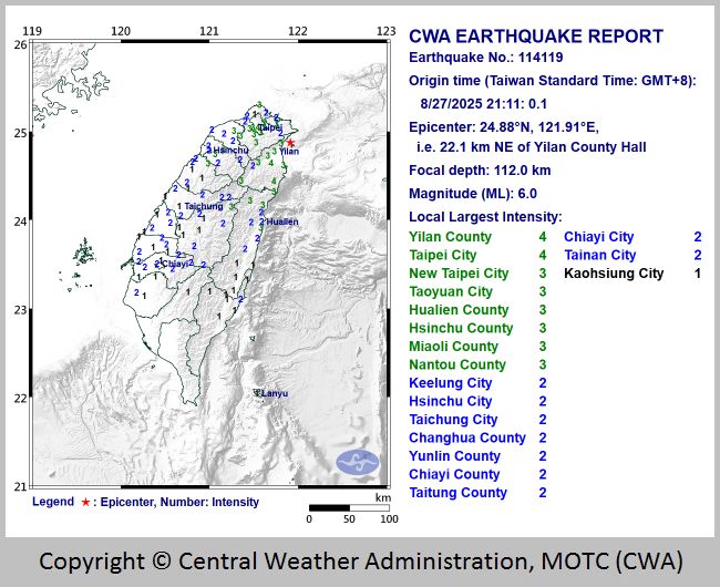
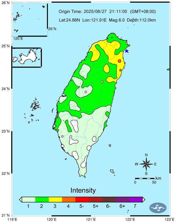
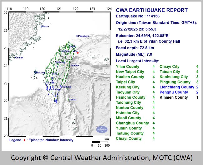
TOP HOME [◆ Counties] [Yilan County]
Disputed outpost
The ROC also claims sovereignty over the uninhabited Diaoyutai Islands (Diaoyutai lieyu 釣魚臺列嶼) in the East China Sea (donghai 東海) and lists them under Tahsi Village (Daxi li 大溪里) in Yilan County's Toucheng Township with the postal area code 290.
In fact, the Diaoyutais and the surrounding waters are controlled by Japan which calls the archipelago "Senkaku Islands" (Jian'ge zhudao 尖閣諸島, "Senkaku Shotō" in Japanese), and today the islands are formally administrated as part of Ishigaki City (Shiyuan shi 石垣市 Ishigaki Shi) under Okinawa Prefecture (Chongsheng xian 沖繩縣 / Okinawa Ken 沖縄県). The islands are also claimed by the PRC which calls them "Diaoyu Islands" (Diaoyu lieyu 釣魚列嶼), and in English the Diaoyutais are sometimes referred to as "Pinnacle Islands".
 The Diaoyutai Islands are located on the continental shelf of the East China Sea in the northbound
part of the Kuroshio Current (heichao 黑潮) and separated from Japan's Ryukyu Islands (Liuqiu liedao
琉球列島Ryūkyū Rettō) by the Okinawa Trough (Zhong Liu jiegou 中琉界溝 /
Zhong Sheng haicao 中繩海槽 in Chinese, Okinawa torafu 沖縄トラフ
in Japanese) with a depth of up to 2,717 meters.
The Diaoyutai Islands are located on the continental shelf of the East China Sea in the northbound
part of the Kuroshio Current (heichao 黑潮) and separated from Japan's Ryukyu Islands (Liuqiu liedao
琉球列島Ryūkyū Rettō) by the Okinawa Trough (Zhong Liu jiegou 中琉界溝 /
Zhong Sheng haicao 中繩海槽 in Chinese, Okinawa torafu 沖縄トラフ
in Japanese) with a depth of up to 2,717 meters.
The archipelago consists of eight islets (listed below) between latitude 25° 43' 13" N and 25° 55' 41" N, longitude 123° 27' 31" E and 124° 33' 38" E. Its westernmost island is Diaoyutai, distances from there to to easternmost Chiwei is 108.37 km and to northernmost Huangwei 27.02 km (source for all distances in this paragraph: Google Earth).
| No. | English name | Chinese name | Japanese name | Area |
|---|---|---|---|---|
| {1} | Diaoyutai Island | diaoyutai 釣魚台 | Uotsuri-shima 魚釣島 | 3.82 km² |
| {2} | Huangwei Island | huangwei yu 黃尾嶼 | Kuba-shima 久場島 | 0.91 km² |
| {3} | Nan Island | nanxiao dao 南小島 | Minamiko-jima 南小島 | 0.40 km² |
| {4} | Bei Island | beixiao dao 北小島 | Kitako-jima 北小島 | 0.31 km² |
| {5} | Chiwei Island | chiwei yu 赤尾嶼 | Taishō-tō 大正島 | 0.06 km² |
| {6} | Chongbei Islet | chongbei yan 沖北岩 | Oki-no-Kita-iwa 沖の北岩 | 0.05 km² |
| {7} | Chongnan Islet | chongnan yan 沖南岩 | Oki-no-Minami-iwa 沖の南岩 | 0.01 km² |
| {8} | Feilai Islet | feilai 飛瀨 | Tobise 飛瀨 | 0.01 km² |
Between 1900 and 1940 the main island was inhabited by Japanese residents when a bonito fish processing plant there employed some 200 workers, but after the factory closed there has been no regular population, and today the islands are forbidden to the public. The following two maps show the Diaoyutai archipelago on the left and the main island (Diaoyutai Island) on the right.


The map below presents the constellation of islands in the East China Sea.

In addition to the Diaoyutai Islands, the map directly above also shows several (undisputed) Japanese island groups located off Taiwan's east coast, including the following from west to east:
- Yaeyama Islands (Bazhongshan liedao 八重山列島 Yaeyama Rettō)—consisting of Yonaguni (Yunaguo dao 與那國島 / Yonaguni Jima 与那国島) [❶], Iriomote (Xibiaodao 西表島 Iriomote Jima) [❷], Kohama Island (Xiaobindao 小濱島 / Kohama Jima 小浜島), Ishigaki (Shiyuandao 石垣島 Ishigaki Jima) [❸] and others;
- Miyako Islands (Gonggu liedao 宮古列島 Miyako Rettō)—consisting of Tarama Island (Duoliangjian dao 多良間島 Tarama Jima) [❹], Miyako Island (Gonggudao 宮古島 Miyako Jima) [❺], Irabu Island (Yiliangbu dao 伊良部島 Irabu Jima), Shimoji Island (Xiadidao 下地島 Shimoji Jima), Kurima Island (Laijiandao 來間島 / Kurima Jima 来間島) and others; and
- Okinawa (Chongsheng 沖繩 / Okinawa 沖縄) [❻].
The Yaeyama Islands, the Miyako Islands, Okinawa and other archipelagos are part of a longer island chain comprising the Ryukyu Islands.
Shortest distances from selected Japanese places to Diaoyutai Island and Taiwan
| Japanese location | Distance to Diaoyutai | Distance to Taiwan | |
|---|---|---|---|
| Yonaguni | ❶ | 147.13 km | 107.50 km |
| Iriomote | ❷ | 147.21 km | 182.79 km |
| Ishigaki | ❸ | 153.11 km | 222.13 km |
| Tarama Island | ❹ | 168.59 km | 272.13 km |
| Miyako Island | ❺ | 200.21 km | 329.17 km |
| Okinawa | ❻ | 418.18 km | 579.64 km |
Shortest distances from Diaoyutai Island to selected ROC-controlled places
| ROC location | Distance to Diaoyutai |
|---|---|
| Keelung harbor | 181.41 km |
| Sandiaojiao | 166.94 km |
| Pengjia Islet | 138.50 km |
| Mianhua Islet/Craig Island | 138.61 km |
Please note that the distance from Yonaguni to Taiwan's Guishan Island is 107.22 km, to Beifang'ao 北方澳 (Suao Township, Yilan County) on Taiwan proper 107.61 km. Above mentioned reference point Cape San Diego aka Cape Santiago (sandiaojiao 三貂角) is located in Gongliao District, New Taipei City. (Distances determined with Google Earth)
TOP HOME [◆ Counties] [Yilan County]
HISTORIC DEVELOPMENT—Japan made its first official move to claim the Diaoyutai Islands on Jan. 14, 1895 during the First Chinese-Japanese War when the Japanese cabinet passed a resolution to annex Uotsuri-shima and Kuba-shima, stating that the islands were "terra nullius" (nobody's land). However, the resolution was not made public at the time (declassified in 1952), and a physical marker was placed there only on May 10, 1969.
After WWII the Ryukyu island chain came under the control of the US which established the United States Military Government of the Ryukyu Islands (Liuqiu liedao Miguo junzhengfu 琉球列島米國軍政府 / Ryūkyū Rettō Beikoku Gunseifu 琉球列島米国軍政府) based in Higashi 東村 (Okinawa) on April 5, 1945, replaced by the United States Civil Administration of the Ryukyu Islands (Liuqiu liedao Miguo minzhengfu 琉球列島米國民政府 / Ryūkyū Rettō Beikoku Minseifu 琉球列島米国民政府) on Dec. 15, 1950. By February 1946 the jurisdiction of the US military administration had been extended to include the Miyako Islands, the Yaeyama Islands, the Amami Islands (Yanmei qundao 奄美群島 Amami Guntō) and the Tokara Islands (Tugala liedao 吐噶喇列島 Tokara Rettō). On June 17, 1971 the US and Japan signed the Okinawa Reversion Agreement which was implemented on May 15, 1972, restoring full Japanese sovereignty over the Ryukyu Islands, including Okinawa Prefecture.
The Diaoyutais became a flashpoint of tension between Japan, China and Japan in the early 1970s. A geophysical survey was conducted in the East China Sea and the Yellow Sea (huanghai 黃海) between Oct. 12 and Nov. 29, 1968 aboard the "R/V F. V. Hunt". Joint participation of scientists from the ROC, the Republic of Korea, and Japan with US scientists was provided through the Economic Commission for Asia and the Far East (ECAFE) of the United Nations. The ECAFE report, titled "Economic Survey of Asia and the Far East 1969" / "Economic Bulletin for Asia and the Far East XX (1969/70)", was published on April 19, 1969 and indicated the possibility of large oil reserves in the area of the disputed archipelago, based on an elementary seismic reflection with a 30,000-joule sparker without test drilling. (ECAFE was renamed United Nations Economic and Social Commission for Asia and the Pacific—abbrev. UNESCAP—on Aug. 1, 1974.) The ROC government claimed the Diaoyutai Islands as ROC territory on April 20, 1971, the PRC government followed suit with its own claim on Dec. 30, 1971.
Since the 2000s there have been occasional confrontations in the waters surrounding the Diaoyutais when boats carrying nationalist activists from China, Hong Kong or Taiwan made symbolic attempts to land on Diaoyutai Island and were blocked by forces of Japan's coast guard. Some of the encounters involved boat collisions, the use of water cannons and arrests of activists by Japanese authorities. Besides PRC patrol vessels frequently entering disputed waters, PRC aircraft began intruding airspace over the Diaoyutais in 2012, latter incidents are usually answered by Japan's air force with the mobilization of fighter jets. The Japanese government on Sept. 11, 2012 formally purchased three islands belonging to the Diaoyutai Islands—Uotsuri-shima, Kitako-jima, and Minamiko-jima—for ¥ 2.05 billion (US$ 26.2 million) from their private owner, Kurihara Kunioki 栗原 國起 (b. 1942).
In Taiwan, support for claiming the disputed islands as belonging to Taiwan is widespread both in the KMT and in the DPP, and the ROC government has been reiterating its claim consistently. On the other hand, former ROC President Lee Teng-hui repeatedly voiced his private opinion after leaving office that the islands in question belong to Japan.
On Aug. 5, 2012 ROC President Ma Ying-jeou suggested the East China Sea Peace Initiative
(donghai heping changyi 東海和平倡議, abbrev. ECSPI) with five points, calling on all parties to
• refrain from antagonistic actions,
• shelve controversies and not abandon dialogue,
• observe international law and resolve disputes through peaceful means,
• seek consensus on a code of conduct in the region, and
• establish a mechanism for cooperation on exploring and developing resources.
This pragmatic approach was intended to reduce tensions by setting the unresolvable sovereignty issue aside, and it eventually led to
the signing of the landmark Taiwan-Japan Fisheries Agreement (Tai Ri yuye xieyi 台日漁業協議) on April 10, 2013, safeguarding the
fishing rights of Taiwanese vessels in the waters surrounding the Diaoyutai Islands.
After international media reported that the Ishigaki City Assembly (Shiyuan shi yihui 石垣市議會 / Ishigaki Shi Gikai 石垣市議会)—which in Japan has jurisdiction over the disputed islands—had proposed a bill to change the islands' administrative name from "Tonoshiro" (Dengyecheng 登野城) to "Tonoshiro Senkaku" (Dengyecheng Jian'ge 登野城尖閣), the Yilan County Council (Yilan xian yiyhui 宜蘭縣議會) on June 11, 2020 approved a motion to change the official name of the disputed Diaoyutai Islands to "Toucheng Township Diaoyutai" (Toucheng Diaoyutai 頭城釣魚台) in preemptive retaliation. The Ishigaki City Council approved its own proposal on June 22, 2020. On July 2, 2020 the Taipei office of the Japan-Taiwan Exchange Association (JTEA) announced that despite the administrative name change Taiwanese fishers' operations in the East China Sea were still protected under the Taiwan-Japan Fisheries Agreement and would remain the same. The Ishigaki City Government formally announced the name change on Oct. 1 that year.
WASHINGTON'S POSITION—The stance of the US government has been that it recognizes the Diaoyutai Islands being under the administration of Japan and therefore being protected under the US-Japan Treaty of Mutual Cooperation and Security which was signed on Jan. 19, 1960.
Background information pertaining to Japan's relations with Taiwan/the ROC can be found on the following pages of this website.
| 🔴 | "Introduction Taiwan / ROC", Facts about Japan's colonial rule over Taiwan |
| 🔴 | "Foreign relations of the ROC", The ROC and Japan |
TOP HOME [◆ Counties] [Yilan County]
Hualien County
- Area and population
- County administration
- Legislative representation
- Additional information about Hualien county
+++++ ⤒ 🏠 [next entity] [previous entity] +++++
| ✉ Hualien County Government 花蓮縣 縣政府 | |
| No. 17 Fucian Road, Hualien City, Hualien County 97001, Taiwan ROC [97001 花蓮縣花蓮市府前路 17 號] ———————————— 🌏 Hualien County Government – Web link |
 |
Area and population
AREA—4,628.5714 km². Please note that all of Hualien County's cities, urban townships and rural townships are designated as indigenous communities. Click here to see a map showing the indigenous communities in the county highlighted with torquoise colour. According to Google Earth, the county limits are located between latitude 23° 03' 00"–24° 12' 36" N and longitude 120° 35' 24"–121° 27' 36" E. The Tropic of Cancer 北回歸線 (latitude 23° 26' 13.8" N) crosses Hualien County.
Adjacent counties/cities: Yilan County, Taichung City, Nantou County, Kaohsiung City, Taitung County
POPULATION DEVELOPMENT SINCE 1974—(figures for the end of the year)
| Year | Inhabitants | Year | Inhabitants | Year | Inhabitants | Year | Inhabitants | |||
|---|---|---|---|---|---|---|---|---|---|---|
| 1974 | 344,023 | 1987 | 355,383 | 2000 | 353,630 | 2013 | 333,897 | |||
| 1975 | 346,914 | 1988 | 352,577 | 2001 | 353,139 | 2014 | 333,392 | |||
| 1976 | 349,398 | 1989 | 350,491 | 2002 | 352,154 | 2015 | 331,945 | |||
| 1977 | 349,304 | 1990 | 352,233 | 2003 | 351,146 | 2016 | 330,911 | |||
| 1978 | 351,220 | 1991 | 353,490 | 2004 | 349,149 | 2017 | 329,237 | |||
| 1979 | 352,968 | 1992 | 355,609 | 2005 | 347,298 | 2018 | 327,968 | |||
| 1980 | 355,178 | 1993 | 357,464 | 2006 | 345,303 | 2019 | 326,247 | |||
| 1981 | 357,530 | 1994 | 358,247 | 2007 | 343,302 | 2020 | 324,372 | |||
| 1982 | 359,891 | 1995 | 358,981 | 2008 | 341,433 | 2021 | 321,358 | |||
| 1983 | 361,017 | 1996 | 358,660 | 2009 | 340,964 | 2022 | 318,892 | |||
| 1984 | 361,674 | 1997 | 358,077 | 2010 | 338,805 | 2023 | 317,489 | |||
| 1985 | 361,549 | 1998 | 356,601 | 2011 | 336,838 | 2024 | 315,374 | |||
| 1986 | 359,340 | 1999 | 355,686 | 2012 | 335,190 | 2025 | 312,807 |
Major indigenous peoples: Amis, Atayal, Kavalan, Sakizaya, Sediq, Truku (see also The indigenous peoples in contemporary Taiwan)
General population statistics about Taiwan / the ROC can be found here.
TOP HOME [◆ Counties] [Hualien County]
County administration
● Hualien county magistrates since 1989
| Tenure | Name | Born/Died | Political Affiliation |
|---|---|---|---|
| 12/1989—4/1993 | Wu Kuo-tong 吳國棟 | b. 1942 | KMT |
| 4/1993—12/1993 @ | Chen Cheng-hsiung 陳正雄 | b. 1937 | KMT |
| 12/1993—12/2001 | Wang Chin-feng 王慶豐 | b. 1933 | KMT |
| 12/2001—5/2003 † | Chang Fu-hsin 張福興 | 1942-2003 | KMT |
| 5/2003—8/2003 @ | K. C. Fan 范光群 | b. 1939 | Ind. |
| 8/2003—12/2009 | Hsieh Shen-san 謝深山 | b. 1939 | KMT |
| 12/2009—9/2018 | Fu Kun-chi 傅崐萁 | b. 1962 | Ind. |
| 9/2018—12/2018 @ | Tsai Pi-chung 蔡碧仲 | b. 1958 | Ind. |
| 12/2018— | Hsu Chen-wei 徐榛蔚 | b. 1968 | KMT |
Note: The tenure of Fu Kun-chi as county magistrate was marred by scandals from the very beginning. Immediately after taking office on Dec. 20, 2009, Fu appointed Hsu Chen-wei 徐榛蔚 as deputy county magistrate—his ex-wife, with whom he had finalized divorce proceedings just two days earlier. The MOI quickly declared the appointment invalid on Dec. 22, 2009, and on April 29, 2011 the Hualien District Court sentenced Fu to 6 months in prison for fake divorce. (The couple reportedly restored normal marital relations by 2016.) Furthermore, an insider trading case kept Fu busy with the courts. The Taichung District Court found Fu guilty on Feb. 5, 2008 and imposed a prison term of 4½ years. Following an appeal, the Taiwan High Court Taichung Branch Court reduced the sentence to 3½ years in prison on June 18, 2010. After the Taiwan High Court in Taipei ordered a retrial, the Taiwan High Court Taichung Branch Court handed down a 9-month prison term on Sept. 26, 2013, but a subsequent appeal led to the ROC Supreme Court on July 17, 2014 returning the case to the Taiwan High Court for a second retrial. The Taiwan High Court sentenced Fu to eight months in prison on June 20, 2017, and the ROC Supreme Court confirmed that verdict on Sept. 12, 2018 in a final ruling, relieving him of his post. Fu started serving his term in Hualien Prison on Sept. 25, 2018 and was released on April 18, 2019. On Jan. 11, 2020 he won the election for Hualien County's seat in the ROC Legislative Yuan.
● Administrative division
1 city, 2 urban townships, 10 rural townships, including 3 Mountain Aborigines communities
(Ⓜ) and 10 Plains Aborigines communities (Ⓟ):
| Fengbin Township 豐濱鄉 977 ⒭ Ⓟ Fenglin Township 鳳林鎮 975 ⒰ Ⓟ Fuli Township 富里鄉 983 ⒭ Ⓟ Guangfu Township 光復鄉 976 ⒭ Ⓟ Hualien City 花蓮市 970 Ⓟ Ji'an Township 吉安鄉 973 ⒭ Ⓟ Ruisui Township 瑞穗鄉 978 ⒭ Ⓟ |
Shoufeng Township 壽豐鄉 974 ⒭ Ⓟ Wanrong Township 萬榮鄉 979 ⒭ Ⓜ Xincheng Township 新城鄉 971 ⒭ Ⓟ Xiulin Township 秀林鄉 972 ⒭ Ⓜ Yuli Township 玉里鎮 981 ⒰ Ⓟ Zhuoxi Township 卓溪鄉 982 ⒭ Ⓜ |
 |  | For a map which highlights the indigenous communities in Hualien County in turquoise colour please click here. |
TOP HOME [◆ Counties] [Hualien County]
Legislative representation
ELECTORAL DISTRICTS FOR THE ROC LEGISLATIVE YUAN—Since 2008 Hualien County as a whole has been represented in the ROC Legislative Yuan by one electoral district only. The table below shows the legislative representation since 2008 (By-elections not included).
| Winner 2008 | Winner 2012 | Winner 2016 | Winner 2020 | Winner 2024 |
|---|---|---|---|---|
| Fu Kun-chi, KMT | Wang Ting-sheng, KMT | Hsiao Bi-khim, DPP | Fu Kun-chi, Ind./KMT | Fu Kun-chi, KMT |
For detailed information about legislative representation in the ROC go to the page Legislative Yuan (Parliament).
TOP HOME [◆ Counties] [Hualien County]
Additional information about Hualien county
PROTECTED AREAS IN THE COUNTY—[part of] Yushan National Park 玉山國家公園; [part of] Taroko National Park 太魯閣國家公園; Yuli Wildlife Refuge 玉里野生動物保護區; Yuli Major Wildlife Habitat 玉里野生動物重要棲息環境; [part of] Danda Major Wildlife Habitat 丹大野生動物重要棲息環境; [part of] Guanshan Major Wildlife Habitat 關山野生動物重要棲息環境; [part of] Coastal Mountain Range Major Wildlife Habitat 海岸山脈野生動物重要棲息環境; Shueilian Major Wildlife Habitat 水璉野生動物重要棲息環境; [part of] Suhua Coastal Protection Area 蘇花海岸保護區; [part of] Huadong Coastal Protection Area 花東沿海保護區
SELECTED SIGHTS—Taroko Gorge 太魯閣, Eternal Spring Shrine 長春祠, Hehuan Mountain 合歡山, Qingshui Cliff 清水斷崖, Tropic of Cancer Marker 北回歸線標誌公園, Hualien Martyr's Shrine 花蓮忠烈祠, Farglory Ocean Park 遠雄海洋公園, Hualien County Stone Sculptural Museum 花蓮縣石雕博物館
SEISMIC ACTIVITY—Hualien County can be considered Taiwan's No. 1 earthquake hotspot—since WWII, no other county or city/special municipality in the ROC was hit by temblors more often. The table directly below is an excerpt of a list showing all major earthquakes in the Taiwan area since 1945 and presents major quakes with epicenter in or off Hualien county.
| Year | Date | Magnitude | Depth | Fatalities | Location of epicenter | Coordinates |
|---|---|---|---|---|---|---|
| 1951 | Oct. 22 | 7.1 | 1 km | 68 | ~ 8.2 km off Xincheng 971 ℹ ℹ | 121.72° E, 24.08° N |
| Nov. 25 | 7.3 | 36 km | 17 | Fuli 983 ℹ | 121.35° E, 23.28° N | |
| 1957 | Feb. 24 | 7.1 | 30 km | 11 | ~ 21.6 km off Shoufeng 974 ℹ | 121.8° E, 23.8° N |
| Oct. 20 | 6.4 | 10 km | 4 | Guangfu 976 ℹ | 121.5° E, 23.7° N | |
| 1966 | March 13 | 7.8 | 42 km | 4 | ~ 86.3 km off Su'ao 270 (Yilan County), near Hualien ℹ | 122.67° E, 24.24° N |
| 1972 | April 24 | 6.7 | 15.4 km | 5 | ~ 2.7 km off Fengbin 977 ℹ | 121.53° E, 23.51° N |
| 1982 | Jan. 23 | 5.8 | 3.25 km | 1 | ~ 2.6 km off Shoufeng 974 ℹ | 121.63° E, 23.91° N |
| 1986 | May 20 | 6.5 | 15.82 km | 1 | Xiulin 972 ℹ | 121.59° E, 24.08° N |
| Nov. 15 | 6.8 | 15 km | 13 | ~ 18.7 km off Hualien City 970 ℹ | 121.83° E, 23.99° N | |
| 1990 | Dec. 13 | 6.5 | 2.82 km | 2 | Shoufeng 974 ℹ | 121.55° E, 23.88° N |
| 1995 | Feb. 23 | 5.8 | 21.7 km | 2 | ~ 1.5 km off Xiulin 972 ℹ | 121.69° E, 24.20° N |
| 2002 | March 31 | 6.8 | 13.8 km | 5 | ~ 46.4 km off Xiulin 972 ℹ ℹ | 122.19° E, 24.14° N |
| 2004 | May 1 | 5.3 | 21.6 km | 2 | Xiulin 972 ℹ ℹ | 121.53° E, 24.08° N |
| 2009 | Dec. 19 | 6.9 | 43.8 km | 1 | ~ 8.6 km off Shoufeng 974 ℹ ℹ | 121.66° E, 23.79° N |
| 2013 | Oct. 31 | 6.4 | 15.0 km | — | Ruisui 978 ℹ ℹ | 121.35° E, 23.57° N |
| 2015 | April 20 | 6.4 | 30.6 km | 1 | ~ 75.1 km off Xiulin 972 ℹ ℹ | 122.44° E, 24.02° N |
| 2018 | Feb. 6 | 6.2 | 6.3 km | 17 | ~ 8.0 km off Xincheng 971 ℹ ℹ ℹ | 121.73° E, 24.10° N |
| 2019 | April 18 | 6.3 | 20.3 km | — | Xiulin 972 ℹ ℹ | 121.56° E, 24.05° N |
| 2021 | April 18 | 6.2 | 14.4 km | — | Shoufeng 974 ℹ ℹ | 121.48° E, 23.86° N |
| 2022 | Jan. 3 | 6.0 | 19.4 km | — | ~ 51.9 km off Xiulin 972 ℹ ℹ | 122.18° E, 24.02° N |
| March 23 | 6.7 | 25.7 km | — | ~ 12.3 km off Fengbin 977 / Changbin 962 (Taitung County) ℹ ℹ | 121.61° E, 23.40° N | |
| June 20 | 6.0 | 6.8 km | — | Guangfu 976 ℹ ℹ | 121.47° E, 23.68° N | |
| Sept. 19 | 6.0 | 13.4 km | — | Zhuoxi 982 ℹ ℹ | 121.30° E, 23.44° N | |
| Dec. 15 | 6.2 | 5.7 km | — | ~ 20.8 km off Shoufeng 974 ℹ ℹ | 121.78° E, 23.77° N | |
| 2024 | April 3 | 7.2 | 15.5 km | 18 | ~ 10.2 km off Shoufeng 974 ℹ ℹ | 121.67° E, 23.77° N |
| April 23 | 6.3 | 5.5 km | — | Shoufeng 974 ℹ ℹ | 121.54° E, 23.85° N | |
| April 27 | 6.1 | 24.9 km | — | ~ 1.6 km off Xiulin 972 ℹ ℹ | 121.68° E, 24.19° N | |
| Aug. 16 | 6.3 | 9.7 km | — | ~ 25.4 km off Shoufeng 974 ℹ ℹ | 121.82° E, 23.74° N |
TOP HOME [◆ Counties] [Hualien County]
Taitung County
- Area and population
- County administration
- Legislative representation
- Additional information about Taitung county
+++++ ⤒ 🏠 [next entity] [previous entity] +++++
| ✉ Taitung County Government 台東縣 縣政府 | |
| No. 276 Chung Shan Road, Taitung City, Taitung County 95001, Taiwan ROC [95001 台東縣台東市中山路 276 號] ———————————— 🌏 Taitung County Government – Web link |
 |
| Logo of Taitung County (for more logo information click here) |  |
Area and population
AREA—3,515.2526 km², including 3,500.1607 km² indigenous communities (99.570 percent of Taitung County's area). Except Ludao Township, all cities, urban townships and rural townships in Taitung County are designated as indigenous communities. Click here to see a map showing the indigenous communities in the county highlighted with torquoise colour. According to Google Earth, the county limits are located between latitude 21° 33' 36"–23° 15' 36" N and longitude 120° 26' 24"–121° 21' 00" E.
Adjacent counties/cities: Kaohsiung City, Pingtung County, Hualien County
POPULATION DEVELOPMENT SINCE 1974—(figures for the end of the year)
| Year | Inhabitants | Year | Inhabitants | Year | Inhabitants | Year | Inhabitants | |||
|---|---|---|---|---|---|---|---|---|---|---|
| 1974 | 289,451 | 1987 | 267,363 | 2000 | 245,312 | 2013 | 224,821 | |||
| 1975 | 291,111 | 1988 | 260,073 | 2001 | 244,612 | 2014 | 224,470 | |||
| 1976 | 289,977 | 1989 | 258,016 | 2002 | 243,965 | 2015 | 222,452 | |||
| 1977 | 286,741 | 1990 | 256,803 | 2003 | 242,842 | 2016 | 220,802 | |||
| 1978 | 284,105 | 1991 | 255,887 | 2004 | 240,373 | 2017 | 219,540 | |||
| 1979 | 281,582 | 1992 | 255,362 | 2005 | 238,943 | 2018 | 218,919 | |||
| 1980 | 281,218 | 1993 | 255,536 | 2006 | 235,957 | 2019 | 216,781 | |||
| 1981 | 281,100 | 1994 | 254,718 | 2007 | 233,660 | 2020 | 215,261 | |||
| 1982 | 281,298 | 1995 | 254,375 | 2008 | 231,849 | 2021 | 213,386 | |||
| 1983 | 279,829 | 1996 | 253,831 | 2009 | 232,497 | 2022 | 212,551 | |||
| 1984 | 277,400 | 1997 | 253,002 | 2010 | 230,673 | 2023 | 211,544 | |||
| 1985 | 276,389 | 1998 | 249,937 | 2011 | 228,290 | 2024 | 210,219 | |||
| 1986 | 272,477 | 1999 | 247,801 | 2012 | 226,252 | 2025 | 208,320 |
Major indigenous peoples: Amis, Bunun, Kavalan, Paiwan, Puyuma, Rukai; Yami [Lanyu] (see also The indigenous peoples in contemporary Taiwan)
General population statistics about Taiwan / the ROC can be found here.
TOP HOME [◆ Counties] [Taitung County]
County administration
● Taitung county magistrates since 1989
| Tenure | Name | Born/Died | Political Affiliation |
|---|---|---|---|
| 12/1989—12/1993 | John Lieh Cheng 鄭烈 | b. 1938 | KMT |
| 12/1993—12/2001 | Chen Chien-nien 陳建年 | b. 1947 | KMT |
| 12/2001—12/2005 | Hsu Ching-yuan 徐慶元 | b. 1957 | DPP |
| 12/2005 | Wu Chun-li 吳俊立 | b. 1962 | KMT |
| 12/2005—4/2006 @ | Lai Shun-hsien 賴順賢 | N/A | N/A |
| 4/2006—12/2009 | Kuang Li-chen 鄺麗貞 | b. 1962 | KMT |
| 12/2009—12/2018 | Justin Huang 黃健庭 | b. 1959 | KMT |
| 12/2018— | Yao Ching-ling 饒慶鈴 | b. 1969 | KMT |
Note: On Aug. 16, 2002 the Taitung District Court sentenced Wu Chun-li to 16 years in prison for corruption; the Taiwan High Court's Hualien branch reduced the sentence to 7 years and 8 months on Aug. 7, 2003. After Wu Chun-li's victory in the Taitung county magistrate election on Dec. 3, 2005, the ROC MOI banned him from taking office on Dec. 19, 2005. The same day Wu Chun-li divorced his wife Kuang Li-chen and then named her his deputy, while ROC Premier Frank Hsieh appointed Lai Shun-hsien acting county magistrate. Kuang went on to win the Taitung county magistrate by-election on April 1, 2006. On Aug. 31 that year the ROC Supreme Court upheld Wu Chun-li's conviction and reduced the sentence to 7 years and 6 months. In connection with the 2005 election the Taiwan High Court on Aug. 4, 2009 sentenced Wu to 2 years imprisonment for vote-buying, but Wu was subsequently acquitted by the Supreme Court on March 3, 2015.
● Administrative division
1 city, 2 urban townships, 13 rural townships, including 5 Mountain Aborigines communities
(Ⓜ) and 10 Plains Aborigines communities (Ⓟ):
| Beinan Township 卑南鄉 954 ⒭
Ⓟ Changbin Township 長濱鄉 962 ⒭ Ⓟ Chenggong Township 成功鎮 961 ⒰ Ⓟ Chishang Township 池上鄉 958 ⒭ Ⓟ Daren Township 達仁鄉 966 ⒭ Ⓜ Dawu Township 大武鄉 965 ⒭ Ⓟ Donghe Township 東河鄉 959 ⒭ Ⓟ Guanshan Township 關山鎮 956 ⒰ Ⓟ |
Haiduan Township 海端鄉 957 ⒭
Ⓜ Jinfeng Township 金峰鄉 964 ⒭ Ⓜ Lanyu Township 蘭嶼鄉 952 ⒭ Ⓜ Ludao Township 綠島鄉 951 ⒭ Luye Township 鹿野鄉 955 ⒭ Ⓟ Taimali Township 太麻里鄉 963 ⒭ Ⓟ Taitung City 台東市 950 Ⓟ Yanping Township 延平鄉 953 ⒭ Ⓜ |
 |  | For a map which highlights the indigenous communities in Taitung County in turquoise colour please click here. |
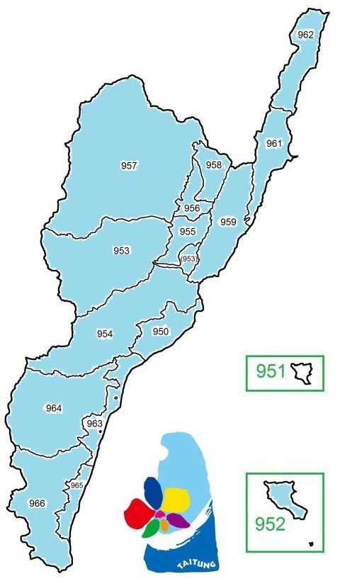
Lanyu Township (952) covers Orchid Island (Lanyu), Ludao Township (951) covers Green Island (Lyudao).
TOP HOME [◆ Counties] [Taitung County]
Legislative representation
ELECTORAL DISTRICTS FOR THE ROC LEGISLATIVE YUAN—Since 2008 Taitung County as a whole has been represented in the ROC Legislative Yuan by one electoral district only. The table below shows the legislative representation since 2008 (By-elections not included).
| Winner 2008 | Winner 2012 | Winner 2016 | Winner 2020 | Winner 2024 |
|---|---|---|---|---|
| Justin Huang, KMT | Huang Chien-pin, KMT | |||
For detailed information about legislative representation in the ROC go to the page Legislative Yuan (Parliament).
TOP HOME [◆ Counties] [Taitung County]
Additional information about Taitung county
PROTECTED AREAS IN THE COUNTY—Taitung Hongye Village Taitung Cycas Nature Reserve 台東紅葉村台東蘇鐵自然保留區; Dawu Tawan Amentotaxus Nature Reserve 大武事業區台灣穗花杉自然保留區; Dawushan Nature Reserve 大武山自然保留區; Taitung County Haiduan Township Sinwulyu River Fish Refuge 臺東縣海端鄉新武呂溪魚類保護區; Coastal Mountain Range Taitung Cycas Reserve 海岸山脈臺東蘇鐵自然保護區; Guanshan Formosan Date Palm Reserve 關山臺灣海棗自然保護區; Dawu Taiwan Keteleeria Nature Reserve 大武臺灣油杉自然保護區; Haiduan Township Sinwulyu River Major Wildlife Habitat 海端鄉新武呂溪野生動物重要棲息環境; [part of] Guanshan Major Wildlife Habitat 關山野生動物重要棲息環境; [part of] Shuangguei Lake Major Wildlife Habitat 雙鬼湖野生動物重要棲息環境; Lijia Major Wildlife Habitat 利嘉野生動物重要棲息環境; [part of] Coastal Mountain Range Major Wildlife Habitat 海岸山脈野生動物重要棲息環境; [part of] Huadong Coastal Protection Area 花東沿海保護區
SELECTED SIGHTS—Chihpen Hot Springs 知本溫泉, Bashian Caves 八仙洞, Beinan Cultural Park 卑南文化公園, East Rift Valley National Scenic Area 台東縱谷國家風景區, Sanxiantai Beach 三仙台礫石灘, Lyudao Lighthouse 綠島燈塔, Green Island Human Rights Culture Park 綠島人權文化園區, Lanyu Flying Fish Cultural Museum 蘭嶼飛魚文化會館, National Museum of Prehistory 國立臺灣史前文化博物館
SEISMIC ACTIVITY—Taitung County can be considered Taiwan's No. 2 earthquake hotspot behind Hualien County. The table directly below is an excerpt of a list showing all major earthquakes in the Taiwan area since 1945 and presents major quakes with epicenter in or off Taitung county.
| Year | Date | Magnitude | Depth | Fatalities | Location of epicenter | Coordinates |
|---|---|---|---|---|---|---|
| 1965 | May 18 | 6.1 | 21 km | — | ~ 30.2 km off Taitung City 950 ℹ | 121.3° E, 22.5° N |
| 1972 | Jan. 25 | 7.5 | 33 km | 1 | ~ 114.0 km off Chenggong 961 ℹ ℹ | 122.26° E, 22.46° N |
| 1978 | Dec. 23 | 7.0 | 4.12 km | 2 | ~ 53.7 km off Changbin 962, near Hualien ℹ | 122.00° E, 23.3° N |
| 1996 | Sept. 6 | 7.1 | 14.8 km | — | ~ 15.5 km off Lanyu 952 ℹ | 121.37° E, 22.00° N |
| 2003 | Dec. 10 | 6.4 | 17.7 km | — | ~ 3.5 km off Chenggong 961 ℹ ℹ | 121.40° E, 23.07° N |
| 2006 | April 1 | 6.2 | 7.2 km | — | Yanping 953 ℹ ℹ | 121.08° E, 22.88° N |
| 2015 | Feb. 14 | 6.3 | 27.8 km | — | ~ 6.8 km off Lyudao 951 ℹ ℹ | 121.40° E, 22.66° N |
| 2016 | Oct. 6 | 6.2 | 23.7 km | — | ~ 13.7 km off Lyudao 951 ℹ ℹ | 121.34° E, 22.63° N |
| 2022 | March 23 | 6.7 | 25.7 km | — | ~ 12.3 km off Changbin 962 / Fengbin 977 (Hualien County) ℹ ℹ | 121.61° E, 23.40° N |
| Sept. 17 | 6.4 | 7.3 km | — | Haiduan 957 ℹ ℹ | 121.16° E, 23.08° N | |
| Sept. 18 | 6.1 | 12.1 km | — | Haiduan 957 ℹ ℹ | 121.18° E, 23.13° N | |
| " | 6.8 | 7.0 km | 1 | Chishang 958 ℹ ℹ | 121.20° E, 23.14° N | |
| 2025 | June 11 | 6.4 | 30.9 km | — | ~ 20.6 km off Changbin 962 ℹ ℹ | 121.68° E, 23.36° N |
| Dec. 24 | 6.1 | 11.9 km | — | Beinan 954 ℹ ℹ | 121.15° E, 22.85° N |
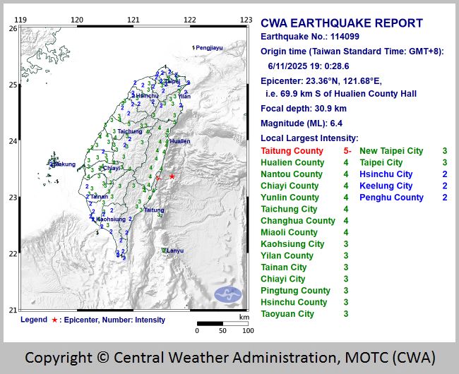
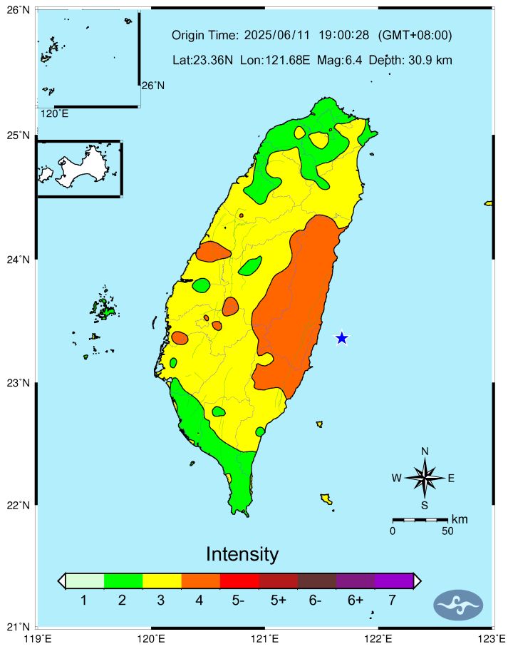
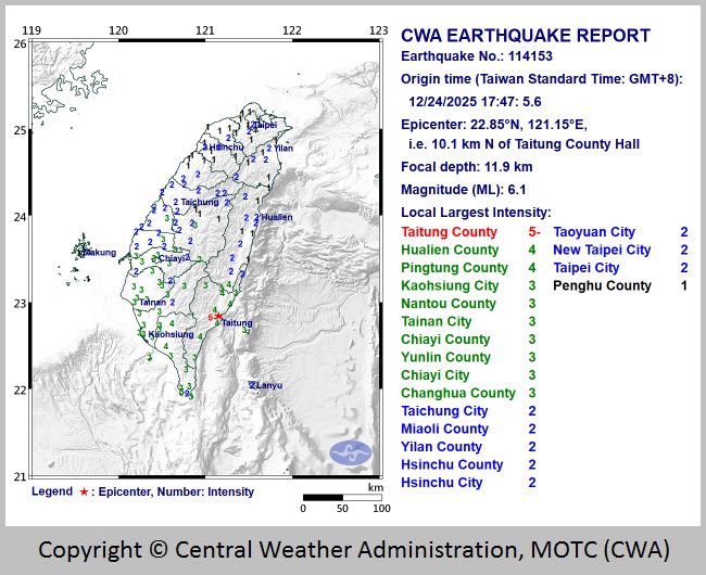
TOP HOME [◆ Counties] [Taitung County]
Penghu County
- Area and population
- County administration
- Legislative representation
- Additional information about Penghu county
- Remarks on Penghu's historical background
+++++ ⤒ 🏠 [next entity] [previous entity] +++++
| ✉ Penghu County Government 澎湖縣 縣政府 | |
| No. 32 Jhihping Road, Magong City, Penghu County 88043, Taiwan ROC [88043 澎湖縣馬公市治平路 32 號] ———————————— 🌏 Penghu County Government – Web link |
 |
This subchapter is about the administrative entity. For the geography of the county's islands click here.
Area and population
AREA—126.8641 km² (no indigenous communities). According to Google Earth, the county limits are located between latitude 23° 06' 36"–23° 27' 00" N and longitude 119° 11' 24"–119° 24' 36" E. The Tropic of Cancer 北回歸線 (latitude 23° 26' 13.8" N) crosses the waters of Penghu County.
Adjacent counties/cities: none
POPULATION DEVELOPMENT SINCE 1974—(figures for the end of the year)
| Year | Inhabitants | Year | Inhabitants | Year | Inhabitants | Year | Inhabitants | |||
|---|---|---|---|---|---|---|---|---|---|---|
| 1974 | 114,462 | 1987 | 99,006 | 2000 | 89,496 | 2013 | 100,400 | |||
| 1975 | 114,700 | 1988 | 97,744 | 2001 | 92,268 | 2014 | 101,758 | |||
| 1976 | 113,631 | 1989 | 96,322 | 2002 | 92,446 | 2015 | 102,304 | |||
| 1977 | 112,171 | 1990 | 95,932 | 2003 | 92,253 | 2016 | 103,263 | |||
| 1978 | 110,535 | 1991 | 95,446 | 2004 | 91,808 | 2017 | 104,073 | |||
| 1979 | 108,784 | 1992 | 95,085 | 2005 | 92,489 | 2018 | 104,440 | |||
| 1980 | 107,043 | 1993 | 95,288 | 2006 | 91,785 | 2019 | 105,207 | |||
| 1981 | 105,674 | 1994 | 92,645 | 2007 | 92,390 | 2020 | 105,952 | |||
| 1982 | 105,172 | 1995 | 90,937 | 2008 | 93,308 | 2021 | 106,340 | |||
| 1983 | 104,083 | 1996 | 90,087 | 2009 | 96,210 | 2022 | 107,223 | |||
| 1984 | 103,175 | 1997 | 91,169 | 2010 | 96,918 | 2023 | 107,739 | |||
| 1985 | 102,282 | 1998 | 89,463 | 2011 | 97,157 | 2024 | 107,901 | |||
| 1986 | 100,927 | 1999 | 89,013 | 2012 | 98,843 | 2025 | 106,716 |
General population statistics about Taiwan / the ROC can be found here.
TOP HOME [◆ Counties] [Penghu County]
County administration
● Penghu county magistrates since 1989
| Tenure | Name | Born/Died | Political Affiliation |
|---|---|---|---|
| 12/1989—10/1992 † | Wang Chien-tung 王乾同 | 1942-1992 | KMT |
| 11/1992—3/1993 @ | Chen Pi-chi 陳丕勣 | b. 1931 | N/A |
| 3/1993—9/1995 | Kao Chih-peng 高植澎 | b. 1954 | DPP |
| 10/1995—12/1997 @ | John Lieh Cheng 鄭烈 | b. 1938 | KMT |
| 12/1997—12/2005 | Lai Feng-wei 賴峰偉 | b. 1953 | KMT |
| 12/2005—12/2014 | Wang Chien-fa 王乾發 | b. 1949 | KMT |
| 12/2014—12/2018 | Chen Kuang-fu 陳光復 | b. 1955 | DPP |
| 12/2018—12/2022 | Lai Feng-wei 賴峰偉 | b. 1953 | KMT |
| 12/2022— | Chen Kuang-fu (second time) | ||
Note: Kao Chih-peng was suspended after being charged with receiving a [relatively small] kickback (NT$ 5000, ca. US$ 200 at that time) from a businessman while serving as head of a public health center in Penghu's Hsiyu (= Xiyu) between 1992 and 1993.
● Administrative division
1 city, 0 urban townships, 5 rural townships:
| Baisha Township 白沙鄉 884 ⒭ Huxi Township 湖西鄉 885 ⒭ Magong City 馬公市 880 |
Qimei Township 七美鄉 883 ⒭ Wang'an Township 望安鄉 882 ⒭ Xiyu Township 西嶼鄉 881 ⒭ |
 |
 |
Penghu County has no indigenous communities. |
TOP HOME [◆ Counties] [Penghu County]
Legislative representation
ELECTORAL DISTRICTS FOR THE ROC LEGISLATIVE YUAN—Since 2008 Penghu County as a whole has been represented in the ROC Legislative Yuan by one electoral district only. The table below shows the legislative representation since 2008 (By-elections not included).
| Winner 2008 | Winner 2012 | Winner 2016 | Winner 2020 | Winner 2024 |
|---|---|---|---|---|
| Lin Pin-kuan, NPSU | ||||
For detailed information about legislative representation in the ROC go to the page Legislative Yuan (Parliament).
TOP HOME [◆ Counties] [Penghu County]
Additional information about Penghu county
PROTECTED AREAS IN THE COUNTY—South Penghu Marine National Park 澎湖南方四島國家公園; [part of] Taijiang National Park台江國家公園; Penghu Columnar Basalt Nature Reserve 澎湖玄武岩自然保留區; Penghu Nanhai Columnar Basalt Nature Reserve 澎湖南海玄武岩自然保留區; Penghu County Cat Islets Seabird Refuge 澎湖縣貓嶼海鳥保護區; Penghu County Wangan Island Green Turtle Breeding Refuge 澎湖縣望安島綠蠵龜產卵棲地保護區; Cat Islets Major Wildlife Habitat 貓嶼野生動物重要棲息環境
SELECTED SIGHTS—Central Street 中央街, Erkan Historical Houses 二崁古厝群聚, Double Heart of Stacked Stones aka Twin Hearts Stone Weir 七美雙心石滬, Whale Cave 澎湖逍遙遊, Tongpan Island basalt columns 桶盤玄武岩石柱, Jibei Sand Spit 吉貝沙尾, Huayu Lighthouse 花嶼燈塔 on Penghu's westernmost island, Chamuyu Lighthouse 查母嶼燈塔 on Penghu's easternmost island, Mudouyu Lighthouse 目斗嶼燈塔, Ruins of Dutch Fengguiwei Fort 風櫃尾荷蘭城堡遺址, Ocean Resources Museum 海洋資源館, Penghu Living Museum 澎湖生活博物館
For further information about Penghu's islands click here.
TOP HOME [◆ Counties] [Penghu County]
Remarks on Penghu's historical background
It has become quite common to treat Penghu's history as a part of Taiwan's history. Geographically, Penghu is indeed closer to Taiwan than to China—Penghu's easternmost island Chamu 查母嶼 aka Sabo Islet is only 40.27 km away from Taiwan's shores, whereas the distance from Mudou 目斗嶼 to China is more than three times that far (128.71 km), and Mudou is the archipelago's islet closest to China. Furthermore, Penghu has administratively been subordinate to Taiwan since more than a century.
On the other hand, while the connection between Penghu and Taiwan can be traced back roughly to the 17th century only, Penghu historically has been associated with China since the 12th century. Before the 1630s Taiwan had virtually no Chinese population, but Chinese settlers from Fujian had started moving to Penghu around the beginning of the Song dynasty (960-1279), and the first documentary evidence of settlement on the Pescadores dates back to 1171. An early administrative unit was the Penghu Patrol Examine Office (Penghu zhai xunjiansi 澎湖寨巡檢司 or Penghu xunjiansi 澎湖巡檢司), set up in the Yuan dynasty (1279-1368) in 1281, belonging to Tongan 同安 in Fujian Province (Fujian xingsheng 福建行省). During the Ming dynasty (1368-1644) that office was under the jurisdiction of Fujian's Quanzhou Prefecture (Quanzhou fu 泉州府), but it was abolished in 1388 because pirates had started using Penghu as a major base, and the regular population of the archipelago was evacuated.
Nevertheless, the islands were still considered Chinese territory then—a claim reiterated forcefully by the Ming in the 17th century. In July 1622 the Dutch East India Company landed in Penghu (commanding officer: Cornelis Reyerszoon) and began construction of a fortress at Fengguiwei 風櫃尾 near the southwestern tip of Penghu proper the following month, intending to establish a trading post. Although the Ming agreed in February 1623 to trade with the Dutch, they insisted that the Dutch withdraw from Penghu. Construction of the Dutch fortifications on Penghu continued and was completed in September 1623. In October that year the first military confrontation occurred, and from May to June 1624 Ming envoys conducted negotiations with the Dutch on Penghu. Under the leadership of Fujian governor Nan Juyi 南居益 (1565-1644), the Ming deployed 200 ships and 10,000 troops to Zhenhai 鎮海 (on Penghu's Baisha Island) by mid-August, vastly outnumbering the 850 soldiers in the Dutch fort where Martinus Sonck had taken command. The Dutch bowed to the pressure, and after dismantling of their Penghu fortress was complete in September 1624, they set off to Taiwan.
After the Manchus had defeated the Ming dynasty on the mainland and founded the Qing dynasty (1644-1911), forces under the command of Ming loyalist Zheng Chenggong 鄭成功 aka "Koxinga" (guoxingye 國姓爺) in 1661 took control of Penghu which in the past had already been used as a base by Koxinga's father, the pirate Zheng Zhilong 鄭芝龍. In 1683 the Qing annihilated the Kingdom of Tungning (dongning wangguo 東寧王國) of Koxinga's clan, and in 1727 they set up the Penghu Subprefecture (Penghu ting 澎湖廳) under Taiwan Prefecture (Taiwan fu 台灣府) of Fujian Province (Fujian sheng 福建省). During the 1884/1885 Sino-French War (Zhong Fa zhanzheng 中法戰爭) Penghu was briefly occupied by French troops who defeated the Qing garrison at Magong'ao 媽宮澳 on March 31, 1885 and left according to the terms of the peace settlement on July 22 (troop withdrawal from the archipelago was completed by Aug. 4 that year). Penghu has formally been considered an administrative part of Taiwan since 1887 when the islands were put under the jurisdiction of the newly established Taiwan province (Taiwan sheng 台灣省) of Qing China as a subprefecture under Tainan Prefecture (Tainan fu 台南府).
The Qing ceded Taiwan and Penghu to Japan in 1895, and for most of the colonial era Penghu was a prefecture in its own right except for the period between 1920 and 1926 when Penghu was placed under Takao Prefecture (Gaoxiong zhou 高雄州, i. e. Kaohsiung) as a district (jun 郡 / gun). In 1945 Taiwan and Penghu came under ROC rule, and the Penghu County Government (Penghu xianzhengfu 澎湖縣政府) was formally set up on Jan. 22, 1946.
| For more information about Taiwan's history click here, for more information about the history of the ROC click here. |
CAMPS FOR VIETNAMESE REFUGEES—Following the collapse of South Vietnam in 1975 and the hostilities between Vietnam and the PRC which began in 1979, waves of refugees fled that war-ravaged country. The ROC government decided to help those arriving on Taiwan's shores as they were regarded victims of Communism, and humanitarian aid for them could be used for propaganda purposes. For the first displaced Vietnamese who were received on June 16, 1977, a Temporary Reception Center for Vietnamese Refugees (Yuenan nanmin linshi jiedaisuo 越南難民臨時接待所) was set up at Chi-kuang Camp (Jiguang yingqu 繼光營區) on Xiyu, and on Dec. 1, 1978 the Free China Relief Association (Zhongguo dalu zaibao jiuji zonghui 中國大陸災胞救濟總會, abbrev. jiuzong 救總 in Chinese and FCRA in English, i. e. today's CARES) established the Indochina Refugees Reception Center (zhongnan bandao nanmin jiedai zhongxin 中南半島難民接待中心), using the Baisha Township Military Camp (Baisha xiang junying 白沙鄉軍營). Refugee accommodation in Penghu ended on Nov. 15, 1988, and altogether ca. 2,000 displaced Vietnamese from 51 boats were admitted. The camps were finally torn down in 2003. (See also the relevant three-part documentary produced by Asio Liu 劉吉雄 on YouTube as well as additional Chinese-language material with images on Google Drive.)
TOP HOME [◆ Counties] [Penghu County]
Kinmen County (Fujian Province)
- Area and population
- County administration
- Legislative representation
- Additional information about Kinmen county
- Frontline fortress
+++++ ⤒ 🏠 [next entity] [previous entity] +++++
| ✉ Kinmen County Government 金門縣 縣政府 | |
| No. 60 Minsheng Road, Jincheng Town, Kinmen County 89345, Fujian ROC [89345 福建省金門縣金城鎮民生路 60 號] ———————————— 🌏 Kinmen County Government – Web link |
 |
This subchapter is about the administrative entity. For the geography of the county's islands click here.
Area and population
AREA—151.6560 km² (no indigenous communities). According to Google Earth, the county limits are located between latitude 24° 13' 48"–24° 18' 36" N and longitude 118° 07' 12"–118° 16' 48" E.
Adjacent counties/cities: none
POPULATION DEVELOPMENT SINCE 1974—(figures for the end of the year)
| Year | Inhabitants | Year | Inhabitants | Year | Inhabitants | Year | Inhabitants | |||
|---|---|---|---|---|---|---|---|---|---|---|
| 1974 | 60,099 | 1987 | 45,987 | 2000 | 53,832 | 2013 | 120,713 | |||
| 1975 | 59,668 | 1988 | 44,427 | 2001 | 56,958 | 2014 | 127,723 | |||
| 1976 | 58,743 | 1989 | 43,249 | 2002 | 58,933 | 2015 | 132,799 | |||
| 1977 | 57,504 | 1990 | 42,754 | 2003 | 60,983 | 2016 | 135,114 | |||
| 1978 | 56,099 | 1991 | 43,442 | 2004 | 64,456 | 2017 | 137,456 | |||
| 1979 | 53,944 | 1992 | 44,170 | 2005 | 70,264 | 2018 | 139,273 | |||
| 1980 | 51,883 | 1993 | 45,807 | 2006 | 76,491 | 2019 | 140,185 | |||
| 1981 | 50,248 | 1994 | 46,516 | 2007 | 81,547 | 2020 | 140,597 | |||
| 1982 | 50,320 | 1995 | 47,394 | 2008 | 84,570 | 2021 | 141,539 | |||
| 1983 | 50,262 | 1996 | 47,924 | 2009 | 93,803 | 2022 | 141,295 | |||
| 1984 | 49,559 | 1997 | 51,080 | 2010 | 97,364 | 2023 | 144,149 | |||
| 1985 | 48,846 | 1998 | 51,060 | 2011 | 103,883 | 2024 | 143,601 | |||
| 1986 | 47,779 | 1999 | 51,731 | 2012 | 113,111 | 2025 | 139,313 |
General population statistics about Taiwan / the ROC can be found here.
TOP HOME [◆ Counties] [Kinmen County]
County administration
● Kinmen county magistrates since 1989
| Tenure | Name | Born/Died | Political Affiliation |
|---|---|---|---|
| 12/1993—12/2001 | Chen Shui-tsai 陳水在 | b. 1948 | KMT |
| 12/2001—12/2009 | Lee Juh-feng 李炷烽 | b. 1953 | NP |
| 12/2009—12/2014 | Lee Wo-shi 李沃士 | b. 1960 | KMT |
| 12/2014—12/2018 | Chen Fu-hai 陳福海 | b. 1963 | Ind. |
| 12/2018—12/2022 | Yang Chen-wu 楊鎮浯 | b. 1972 | KMT |
| 12/2022— | Chen Fu-hai (second time) | ||
Note: After the ROC government was relocated to Taiwan following the occupation of the Chinese mainland by Communist forces, the islands of Kinmen and Matsu were on the front line of military resistance against an anticipated invasion attempt by Beijing. Due to the necessity of maintaining a strong presence of the ROC armed forces on the islands, local administration on Kinmen was different from other county governments on Taiwan proper and was called 'War Zone Administration Committee' (zhandi zhengwu weiyuanhui 戰地政務委員會) instead, headed by a war zone commissioner (zhandi zhengwu weiyuan 戰地政務委員). Civilian administration on Kinmen was finally restored on Nov. 7, 1992, the first direct and free election of Kinmen County's magistrate took place on Nov. 27, 1993.
● Administrative division
0 cities, 3 urban townships, 3 rural townships:
| Jincheng Township 金城鎮 893 ⒰ Jinhu Township 金湖鎮 891 ⒰ Jinning Township 金寧鄉 892 ⒭ |
Jinsha Township 金沙鎮 890 ⒰ Lieyu Township 烈嶼鄉 894 ⒭ Wuqiu Township 烏坵鄉 896 ⒭ |


Big Kinmen and Little Kinmen are connected by the Kinmen Bridge (Jinmen daqiao 金門大橋) with a length of 5.4 km, linking Jinning Township and Lieyu Township as shown in the map above right. The bridge was under construction since May 2012 and opened to traffic on Oct. 30, 2022.
Kinmen County has no indigenous communities.
 Please note that Wuqiu Township, comprising the islets Daqiu 大坵 and Xiaoqiu 小坵 (distance between
them: 1.24 km), is geographically not located in the direct vicinity of the Kinmen Islands. Wuqiu Township lies off Fujian's Putian
County 莆田縣, actually almost in the middle between Kinmen and Matsu—distance from Daqiu to Big Kinmen's Jinsha Town
114 km, distance from Daqiu to Dongjyu (Juguang Township, Lienchiang County) 117 km. A complete list showing the shortest
distances between Daqiu and Xiaoqiu, respectively to selected locations is shown directly below. Source: Google Earth;
reference points in the PRC are on the mainland, not offshore islands.
Please note that Wuqiu Township, comprising the islets Daqiu 大坵 and Xiaoqiu 小坵 (distance between
them: 1.24 km), is geographically not located in the direct vicinity of the Kinmen Islands. Wuqiu Township lies off Fujian's Putian
County 莆田縣, actually almost in the middle between Kinmen and Matsu—distance from Daqiu to Big Kinmen's Jinsha Town
114 km, distance from Daqiu to Dongjyu (Juguang Township, Lienchiang County) 117 km. A complete list showing the shortest
distances between Daqiu and Xiaoqiu, respectively to selected locations is shown directly below. Source: Google Earth;
reference points in the PRC are on the mainland, not offshore islands.
| Island | ~ PRC | ~ Taiwan proper | ~ Kinmen | ~ Matsu |
|---|---|---|---|---|
| Daqiu | 26.09 km | 131.52 km | 114.28 km | 117.60 km |
| Xiaoqiu | 28.58 km | 129.36 km | 115.61 km | 117.69 km |
Following the high-profile visit of US House of Representatives speaker Nancy Pelosi to Taiwan in early August 2022, Taiwanese media reported that drones deployed by the PRC military penetrated airspace over Kinmen Island and Peiting Island, according to the ROC MND the first time that PLA UAVs violated Kinmen airspace.
TOP HOME [◆ Counties] [Kinmen County]
Legislative representation
ELECTORAL DISTRICTS FOR THE ROC LEGISLATIVE YUAN—Since 2008 Kinmen County as a whole has been represented in the ROC Legislative Yuan by one electoral district only. The table below shows the legislative representation since 2008 (By-elections not included).
| Winner 2008 | Winner 2012 | Winner 2016 | Winner 2020 | Winner 2024 |
|---|---|---|---|---|
| Chen Fu-hai, Ind. | Yang Ying-hsiung, KMT | Yang Chen-wu, KMT | ||
For detailed information about legislative representation in the ROC go to the page Legislative Yuan (Parliament).
TOP HOME [◆ Counties] [Kinmen County]
Additional information about Kinmen county
PROTECTED AREAS IN THE COUNTY—Kinmen National Park 金門國家公園
SELECTED SIGHTS—Mofan Street 模範街, Wentai Pagoda 文臺寶塔, Juguang Tower 莒光樓, Gulongtou Zhenwei Residence 古龍頭振威第, Kinmen Folk Culture Village 金門民俗文化村, Kinmen National Park 金門國家公園, Jhaishan Tunnel 翟山坑道, Mt. Lion Howitzer Front 獅山砲陣地, Beishan Broadcast Wall 北山播音牆, Guningtou War Museum 古寧頭戰史館, August 23rd Artillery War Museum 八二三戰史館
For further information about Kinmen's islands click here.
TOP HOME [◆ Counties] [Kinmen County]
Frontline fortress
Before the beginning of the post-WWII civil war between KMT-led ROC government forces and Chinese Communist rebel troops, Kinmen was no place of special significance on the Chinese coastline. However, with the loss of the mainland and the retreat of the ROC armed forces and government to Taiwan around 1948/1949, Kinmen suddenly found itself in a pivotal position, the last frontier to ward off an attack of the Chinese Communists on Taiwan. The islands have remained a military flashpoint ever since, and events like the Guningtou Battle in October 1949 as well as the 823 Artillery Bombardment in August 1958 and the following years left no doubt that the ROC had no choice but keep a heavily armed garrison on Kinmen.
With the enemy less than three kilometers away, troops stationed on Kinmen always had to be on high alert. But while the military presence on Kinmen, as necessary as it was, certainly did contribute to prevent the PRC from invading Taiwan, some incidents were less glorious.
One particular regional problem in the 1970s and 1980s were refugees from Indochina (especially Vietnam) trying to find protection in Hong Kong—or in Taiwan. While some refugees were admitted on Penghu, the practice on Kinmen was to scare refugees (or other non-local boats of unclear origin entering Kinmen waters without authorization) off. Unauthorized vessels were ordered to leave, but when they reached the shore, ROC troops had shoot-to-kill orders issued by the Kinmen Defense Command (Jinmen fangwei silingbu 金門防衛司令部, abbrev. KDC). The MND was aware of the situation but turned a blind eye. For example, in January 1985 eight unarmed fishermen from the PRC suffered engine failure and floated ashore at Shi Islet 獅嶼. On orders of the KDC, the entire crew was killed.
The Lieyu Massacre
On March 6, 1987, a boat of Vietnamese refugees who had been rejected in Hong Kong arrived in Kinmen to request political asylum.
The KDC rejected the request and on the morning of March 7 ordered a patrol boat to tow away the refugee boat from the shore, with a
warning not to return. That afternoon the refugees came close to the shores of Little Kinmen 小金門 (aka Lieyu 烈嶼) in heavy fog
near a military sensitive location. Local troops opened fire, killing three, and subsequently the KDC ordered the killing of all
surviving passengers. The number of total casualties is estimated to be at least 19, the corpses being hastily buried on the beach.
Despite cover-up attempts by the military leadership (including high-ranking officers like Hau Pei-tsun 郝柏村), accounts of the events
eventually surfaced, partly due to testimony of local civilian witnesses and efforts of legislators
like Freddy Lim 林昶佐. Nevertheless, none of the troops involved in the killing or their commanding officers spent one day in jail as
punishment for the atrocities.
In this context it should be pointed out that the ROC never signed the Convention relating to
the Status of Refugees.
TOP HOME [◆ Counties] [Kinmen County]
Lienchiang County (Fujian Province)
- Area and population
- County administration
- Legislative representation
- Additional information about Lienchiang county
+++++ ⤒ 🏠 [next entity] [previous entity] +++++
| ✉ Lienchiang County Government 連江縣 縣政府 | |
| No. 76 Jieshou Village, Nangan Township, Lienchiang County 20941, Fujian ROC [20941 福建省連江縣南竿鄉介壽村 76 號] ———————————— 🌏 Lienchiang County Government – Web link |
 |
| Alternative logo | |
Lienchiang County is the administrative name of the Matsu Islands, their geography is described here.
Area and population
AREA—28.8000 km² (no indigenous communities). According to Google Earth, the county limits are located between latitude 26° 04' 48"–26° 10' 12" N and longitude 119° 32' 24"–120° 00' 00" E.
Adjacent counties/cities: none
POPULATION DEVELOPMENT SINCE 1974—(figures for the end of the year)
| Year | Inhabitants | Year | Inhabitants | Year | Inhabitants | Year | Inhabitants | |||
|---|---|---|---|---|---|---|---|---|---|---|
| 1974 | 14,844 | 1987 | 6,411 | 2000 | 6,733 | 2013 | 12,165 | |||
| 1975 | 13,719 | 1988 | 6,158 | 2001 | 8,851 | 2014 | 12,506 | |||
| 1976 | 12,804 | 1989 | 5,898 | 2002 | 8,763 | 2015 | 12,547 | |||
| 1977 | 11,422 | 1990 | 5,585 | 2003 | 8,806 | 2016 | 12,595 | |||
| 1978 | 10,678 | 1991 | 5,547 | 2004 | 9,359 | 2017 | 12,880 | |||
| 1979 | 9,809 | 1992 | 5,958 | 2005 | 10,345 | 2018 | 13,056 | |||
| 1980 | 9,058 | 1993 | 5,603 | 2006 | 9,786 | 2019 | 13,089 | |||
| 1981 | 8,199 | 1994 | 5,566 | 2007 | 9,946 | 2020 | 13,279 | |||
| 1982 | 7,511 | 1995 | 5,856 | 2008 | 9,755 | 2021 | 13,645 | |||
| 1983 | 7,338 | 1996 | 6,061 | 2009 | 9,919 | 2022 | 13,983 | |||
| 1984 | 7,123 | 1997 | 8,419 | 2010 | 9,944 | 2023 | 14,039 | |||
| 1985 | 6,926 | 1998 | 6,655 | 2011 | 10,106 | 2024 | 13,950 | |||
| 1986 | 6,693 | 1999 | 6,560 | 2012 | 11,310 | 2025 | 13,621 |
General population statistics about Taiwan / the ROC can be found here.
Please note that more than half of the county's population lives in Nan'gan Township.
TOP HOME [◆ Counties] [Lienchiang County]
County administration
● Lienchiang county magistrates since 1989
| Tenure | Name | Born/Died | Political Affiliation |
|---|---|---|---|
| 12/1993—12/1997 | Tsao Chang-shun 曹常順 | b. 1943 | KMT |
| 12/1997—12/2001 | L. C. Liu 劉立群 | 1951-2003 | KMT |
| 12/2001—12/2009 | Chen Hsueh-sheng 陳雪生 | b. 1952 | PFP |
| 12/2009—12/2014 | Yang Sui-sheng 楊綏生 | b. 1954 | KMT |
| 12/2014—12/2022 | Liu Cheng-ying 劉增應 | b. 1958 | KMT |
| 12/2022— | Wang Chung-ming 王忠銘 | b. 1958 | KMT |
Note: The first direct and free election of Lienchiang County's magistrate took place on Nov. 27, 1993 after civilian administration was restored there on Nov. 7, 1992.
● Administrative division
0 cities, 0 urban townships, 4 rural townships:
| Beigan Township 北竿鄉 210 ⒭ Dongyin Township 東引鄉 212 ⒭ |
Juguang Township 莒光鄉 211 ⒭ Nan'gan Township 南竿鄉 209 ⒭ |
 |
 |
Lienchiang County has no indigenous communities. |
TOP HOME [◆ Counties] [Lienchiang County]
Legislative representation
ELECTORAL DISTRICTS FOR THE ROC LEGISLATIVE YUAN—Since 2008 Lienchiang County as a whole has been represented in the ROC Legislative Yuan by one electoral district only. The table below shows the legislative representation since 2008 (By-elections not included).
| Winner 2008 | Winner 2012 | Winner 2016 | Winner 2020 | Winner 2024 |
|---|---|---|---|---|
| Tsao Erh-chung, KMT | Chen Hsueh-sheng, Ind. | |||
For detailed information about legislative representation in the ROC go to the page Legislative Yuan (Parliament).
TOP HOME [◆ Counties] [Lienchiang County]
Additional information about Lienchiang county
PROTECTED AREAS IN THE COUNTY—Matsu Islands Tern Refuge 馬祖列島燕鷗保護區; Matsu Islands Major Wildlife Habitat 馬祖列島野生動物重要棲息環境
SELECTED SIGHTS—Beihai Tunnel 北海坑道, Dongyong Lighthouse 東湧燈塔, War and Peace Memorial Park Exhibition Center 戰爭和平紀念公園主題館, Matsu Folk Culture Museum 馬祖民俗文物館, Northernmost Frontier 國之北疆
For further information about the islands of Lienchiang county (Matsu) click here.
TOP HOME [◆ Counties] [Lienchiang County]
===== ===== ===== ===== =====
◆ County-level cities in the ROC
(Jump to ROC special municipalities or to ROC counties)
++++++++++ TOP HOME [next chapter] [previous chapter] ++++++++++
Keelung City
- Area and population
- City administration
- Legislative representation
- Additional information about Keelung city
+++++ ⤒ 🏠 [next entity] [previous entity] +++++
| ✉ Keelung City Government 基隆市 市政府 | |
| No. 1 Yi 1st Road, Jhongjheng District, Keelung City 20201, Taiwan ROC [20201 基隆市中正區義一路 1 號] ———————————— 🌏 Keelung City Government – Web link |
 |
Area and population
AREA—132.7589 km² (no indigenous communities). According to Google Earth, the city limits are located between latitude 25° 01' 48"–25° 06' 00" N and longitude 121° 22' 12"–121° 21' 48" E.
Adjacent counties/cities: New Taipei City
POPULATION DEVELOPMENT SINCE 1974—(figures for the end of the year)
| Year | Inhabitants | Year | Inhabitants | Year | Inhabitants | Year | Inhabitants | |||
|---|---|---|---|---|---|---|---|---|---|---|
| 1974 | 340,692 | 1987 | 348,541 | 2000 | 388,425 | 2013 | 374,914 | |||
| 1975 | 341,383 | 1988 | 348,672 | 2001 | 390,966 | 2014 | 373,077 | |||
| 1976 | 342,544 | 1989 | 350,283 | 2002 | 391,450 | 2015 | 372,105 | |||
| 1977 | 342,168 | 1990 | 352,919 | 2003 | 392,242 | 2016 | 372,100 | |||
| 1978 | 342,678 | 1991 | 355,894 | 2004 | 392,337 | 2017 | 371,458 | |||
| 1979 | 345,392 | 1992 | 359,482 | 2005 | 391,727 | 2018 | 370,155 | |||
| 1980 | 344,867 | 1993 | 363,037 | 2006 | 390,633 | 2019 | 368,893 | |||
| 1981 | 347,828 | 1994 | 364,520 | 2007 | 390,397 | 2020 | 367,577 | |||
| 1982 | 349,686 | 1995 | 368,771 | 2008 | 388,979 | 2021 | 363,977 | |||
| 1983 | 351,707 | 1996 | 374,199 | 2009 | 388,321 | 2022 | 361,526 | |||
| 1984 | 352,666 | 1997 | 379,370 | 2010 | 384,134 | 2023 | 362,255 | |||
| 1985 | 351,524 | 1998 | 382,118 | 2011 | 379,927 | 2024 | 361,441 | |||
| 1986 | 349,616 | 1999 | 385,201 | 2012 | 377,153 | 2025 | 359,836 |
General population statistics about Taiwan / the ROC can be found here.
TOP HOME [◆ County-level cities] [Keelung City]
City administration
● Keelung city mayors since 1989
| Tenure | Name | Born/Died | Political Affiliation |
|---|---|---|---|
| 12/1989—12/1997 | Lin Shui-mu 林水木 | b. 1937 | KMT |
| 12/1997—12/2001 | John C. Y. Lee 李進勇 | b. 1951 | DPP |
| 12/2001—2/2007 † | Hsu Tsai-li 許財利 | 1947-2007 | KMT |
| 2/2007—3/2007 @ | Syu Cing-kun 許清坤 | N/A | N/A |
| 3/2007—5/2007 @ | Chen Chun-kuang 陳重光 | b. 1945 | DPP |
| 5/2007—12/2014 | Chang Tong-rong 張通榮 | b. 1949 | KMT |
| 12/2014—12/2022 | Lin Yu-chang 林右昌 | b. 1971 | DPP |
| 12/2022— | Hsieh Kuo-liang 謝國樑 | b. 1975 | KMT |
Note: The KMT revoked Hsu Tsai-li's membership after the Keelung District Court sentenced Hsu to 7 years in prison for corruption on Sept. 21, 2006. On July 26, 2013 the same court sentenced Chang Tong-rong to 20 months in prison for influence-peddling, the Taiwan High Court suspended that sentence on Oct. 13, 2015.
● Administrative division
7 districts:
| Anle District 安樂區 204 Nuannuan District 暖暖區 205 Qidu District 七堵區 206 Ren'ai District 仁愛區 200 |
Xinyi District 信義區 201 Zhongshan District 中山區 203 Zhongzheng District 中正區 202 |
Zhongzheng District includes the Three Northern Islets (beifang sandao 北方三島)—Huaping 花瓶嶼 [0.03 km²], Mianhua 棉花嶼 [0.13 km²] and Pengjia 彭佳嶼 [1.14 km²].
 |
 |
Keelung City has no indigenous communities. |
Two more maps of the Keelung area can be viewed here for more clarity—one provided by Maps-for-free.com (copyright: © Relief Maps, computed by Hans Braxmeier; click here), the other derived from Google Earth (click here).
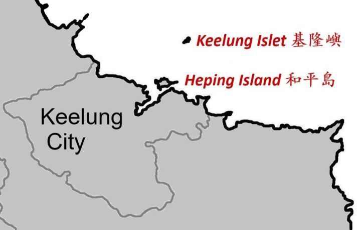 Two other islands under Keelung City's jurisdiction should be mentioned, both belonging
to Zhongzheng District as well:
Two other islands under Keelung City's jurisdiction should be mentioned, both belonging
to Zhongzheng District as well:
- Heping Island (heping dao 和平島), [0.663 km²] 76 m off Keelung harbor, and
- Keelung Islet (jilong yu 基隆嶼) [23.91 ha] 3.9 km off Taiwan's coast.
Archaeological excavations on Heping Island conducted in 2014 uncovered structures created by Spanish colonizers in the 17th century. During the 1884/1885 Sino-French War (Zhong Fa zhanzheng 中法戰爭) Keelung was temporarily occupied by French troops between October 1884 and June 1885.
TOP HOME [◆ County-level cities] [Keelung City]
Legislative representation
ELECTORAL DISTRICTS FOR THE ROC LEGISLATIVE YUAN—Since 2008 Keelung City as a whole has been represented in the ROC Legislative Yuan by one electoral district only. The table below shows the legislative representation since 2008 (By-elections not included).
| Winner 2008 | Winner 2012 | Winner 2016 | Winner 2020 | Winner 2024 |
|---|---|---|---|---|
| Lin Pei-hsiang, KMT | ||||
For detailed information about legislative representation in the ROC go to the page Legislative Yuan (Parliament).
TOP HOME [◆ County-level cities] [Keelung City]
Additional information about Keelung city
PROTECTED AREAS IN THE CITY—Mianhua and Huaping Islets Wildlife Refuge 棉花嶼、花瓶嶼野生動物保護區 [offshore]; Mianhua Islet Major Wildlife Habitat 棉花嶼野生動物重要棲息環境 [offshore]; Huaping Islet Major Wildlife Habitat 花瓶嶼野生動物重要棲息環境 [offshore]
SELECTED SIGHTS—Fairy Cave 仙洞巖, Chungcheng Park 中正公園, Bisha Fishing Port 碧砂漁港, Ershawan Fort 二沙灣, Baimiweng Fort 白米甕砲台, Dawulun Fort 大武崙砲台, Heping Island 和平島, National Museum of Marine Science and Technology 國立海洋科技博物館
TOP HOME [◆ County-level cities] [Keelung City]
Hsinchu City
- Area and population
- City administration
- Legislative representation
- Additional information about Hsinchu city
+++++ ⤒ 🏠 [next entity] [previous entity] +++++
| ✉ Hsinchu City Government 新竹市 市政府 | |
| No. 120 Zhongzheng Road, North District, Hsinchu City 30051, Taiwan ROC [30051 新竹市北區中正路 120 號] ———————————— 🌏 Hsinchu City Government – Web link |
 |
| Alternative logo |  |
(Jump to Hsinchu County) (Hsinchu before 1982)
Area and population
AREA—104.1526 km² (no indigenous communities). According to Google Earth, the city limits are located between latitude 24° 25' 12"–24° 30' 36" N and longitude 120° 31' 12"–121° 01' 12" E.
Adjacent counties/cities: Hsinchu County, Miaoli County
POPULATION DEVELOPMENT SINCE 1982—(figures for the end of the year)
| Year | Inhabitants | Year | Inhabitants | Year | Inhabitants | Year | Inhabitants | |||
|---|---|---|---|---|---|---|---|---|---|---|
| 1981 | N/A | 1993 | 335,460 | 2005 | 390,692 | 2017 | 441,132 | |||
| 1982 | 288,880 | 1994 | 338,140 | 2006 | 394,757 | 2018 | 445,635 | |||
| 1983 | 292,740 | 1995 | 340,255 | 2007 | 399,035 | 2019 | 448,803 | |||
| 1984 | 297,324 | 1996 | 345,954 | 2008 | 405,371 | 2020 | 451,412 | |||
| 1985 | 304,010 | 1997 | 351,800 | 2009 | 411,587 | 2021 | 452,640 | |||
| 1986 | 306,088 | 1998 | 356,243 | 2010 | 415,344 | 2022 | 452,473 | |||
| 1974 | 309,899 | 1999 | 361,958 | 2011 | 420,052 | 2023 | 456,475 | |||
| 1988 | 314,626 | 2000 | 368,439 | 2012 | 425,071 | 2024 | 457,242 | |||
| 1989 | 319,197 | 2001 | 373,296 | 2013 | 428,483 | 2025 | 455,740 | |||
| 1990 | 324,426 | 2002 | 378,797 | 2014 | 431,988 | |||||
| 1991 | 328,911 | 2003 | 382,897 | 2015 | 434,060 | |||||
| 1992 | 332,707 | 2004 | 386,950 | 2016 | 437,337 | |||||
General population statistics about Taiwan / the ROC can be found here.
TOP HOME [◆ County-level cities] [Hsinchu City]
City administration
Hsinchu city was administratively split from Hsinchu county on July 1, 1982, thus becoming a county-level city in its own right. (See additional remarks below.)
● Hsinchu city mayors since 1989
| Tenure | Name | Born/Died | Political Affiliation |
|---|---|---|---|
| 12/1989—12/1997 | Tong Shen-nan 童勝男 | b. 1944 | KMT |
| 12/1997—12/2001 | Tsai Jen-chien 蔡仁堅 | b. 1952 | DPP |
| 12/2001—12/2009 | Lin Junq-tzer 林政則 | b. 1944 | KMT |
| 12/2009—12/2014 | Hsu Ming-tsai 許明財 | b. 1953 | KMT |
| 12/2014—7/2022 | Lin Chih-chien 林智堅 | b. 1975 | DPP |
| 7/2022—12/2022 @ | Chen Chang-hsien 陳章賢 | N/A | N/A |
| 12/2022—7/2024 | Ann Kao 高虹安 | b. 1984 | TPP |
| 7/2024—12/2025 @ | Chiu Chen-yuan 邱臣遠 | b. 1981 | TPP |
| 12/2025— | Ann Kao (reinstated) | ||
Ann Kao was sentenced to 7 years and 4 months in prison and suspended as Hsinchu mayor on July 26, 2024 after the Taipei District Court found her guilty of contravening the Anti-Corruption Act (tanwu zhizui tiaoli 貪污治罪條例) and the ROC Criminal Code (Zhonghua minguo xingfa 中華民國刑法). Exactly one year later she survived a recall vote. After the Taiwan High Court acquitted her of corruption on Dec. 16, 2025, the MOI the following day approved her reinstatement as mayor.
● Administrative division
3 districts:
| East District 東區 300 | North District 北區 300 | Xiangshan District 香山區 300 |
 |
 |
Hsinchu City has no indigenous communities. |
TOP HOME [◆ County-level cities] [Hsinchu City]
Legislative representation
ELECTORAL DISTRICTS FOR THE ROC LEGISLATIVE YUAN—Since 2008 Hsinchu City as a whole has been represented in the ROC Legislative Yuan by one electoral district only. The table below shows the legislative representation since 2008 (By-elections not included).
| Winner 2008 | Winner 2012 | Winner 2016 | Winner 2020 | Winner 2024 |
|---|---|---|---|---|
| Ker Chien-ming, DPP | ||||
For detailed information about legislative representation in the ROC go to the page Legislative Yuan (Parliament).
TOP HOME [◆ County-level cities] [Hsinchu City]
Additional information about Hsinchu city
PROTECTED AREAS IN THE CITY—Hsinchu City Coastal Wildlife Refuge 新竹市濱海野生動物保護區; Siangshan Wetland Major Wildlife Habitat 香山溼地野生動物重要棲息環境 [coastal area]
SELECTED SIGHTS—Guchifeng 古奇峰, Hsinchu Zoo 新竹市立動物園, City God Temple 城隍廟 and Chenghuang Temple Night Market 城隍廟夜市, Glass Museum of Hsinchu City 新竹市立玻璃工藝博物館, Hsinchu Museum of Military Dependents Village 新竹市眷村博物館
TOP HOME [◆ County-level cities] [Hsinchu City]
Chiayi City
- Area and population
- City administration
- Legislative representation
- Additional information about Chiayi city
+++++ ⤒ 🏠 [previous entity] [Overview] +++++
| ✉ Chiayi City Government 嘉義市 市政府 | |
| No. 199 Jhongshan Road, East District, Chiayi City 60006, Taiwan ROC [60006 嘉義市東區中山路 199 號] ———————————— 🌏 Chiayi City Government – Web link |
 |
| Alternative logo |  |
(Jump to Chiayi County) (Chiayi before 1982)
Area and population
AREA—60.0256 km² (no indigenous communities). According to Google Earth, the city limits are located between latitude 23° 15' 36"–23° 18' 36" N and longitude 120° 13' 48"–120° 18' 00" E. The Tropic of Cancer 北回歸線 (latitude 23° 26' 13.8" N) crosses Chiayi City.
Adjacent counties/cities: Chiayi County
POPULATION DEVELOPMENT SINCE 1982—(figures for the end of the year)
| Year | Inhabitants | Year | Inhabitants | Year | Inhabitants | Year | Inhabitants | |||
|---|---|---|---|---|---|---|---|---|---|---|
| 1981 | N/A | 1993 | 258,599 | 2005 | 271,701 | 2017 | 269,398 | |||
| 1982 | 252,376 | 1994 | 260,368 | 2006 | 272,364 | 2018 | 268,622 | |||
| 1983 | 252,906 | 1995 | 261,391 | 2007 | 273,075 | 2019 | 267,690 | |||
| 1984 | 253,016 | 1996 | 262,860 | 2008 | 273,793 | 2020 | 266,005 | |||
| 1985 | 253,573 | 1997 | 262,822 | 2009 | 273,861 | 2021 | 264,727 | |||
| 1986 | 254,001 | 1998 | 263,050 | 2010 | 272,390 | 2022 | 262,924 | |||
| 1974 | 254,875 | 1999 | 265,109 | 2011 | 271,526 | 2023 | 263,584 | |||
| 1988 | 255,994 | 2000 | 266,183 | 2012 | 271,220 | 2024 | 262,177 | |||
| 1989 | 256,165 | 2001 | 267,993 | 2013 | 270,872 | 2025 | 261,592 | |||
| 1990 | 257,597 | 2002 | 267,907 | 2014 | 270,883 | |||||
| 1991 | 258,468 | 2003 | 269,594 | 2015 | 270,366 | |||||
| 1992 | 258,698 | 2004 | 270,341 | 2016 | 269,874 | |||||
General population statistics about Taiwan / the ROC can be found here.
TOP HOME [◆ County-level cities] [Chiayi City]
City administration
Chiayi city was administratively split from Chiayi county on July 1, 1982, thus becoming a county-level city in its own right. (See additional remarks below.)
● Chiayi city mayors since 1989
| Tenure | Name | Born/Died | Political Affiliation |
|---|---|---|---|
| 12/1989—12/1997 | Chang Wen-ying 張文英 | b. 1938 | Ind. |
| 12/1997—5/2000 | Chang Po-ya 張博雅 | b. 1942 | Ind. |
| 5/2000—12/2005 | Chen Li-chen 陳麗貞 | b. 1958 | Ind./DPP |
| 12/2005—12/2014 | Huang Min-hui 黃敏惠 | b. 1959 | KMT |
| 12/2014—12/2018 | Twu Shiing-jer 涂醒哲 | b. 1951 | DPP |
| 12/2018— | Huang Min-hui 黃敏惠 | b. 1959 | KMT |
Note: Between 5/2000 and 12/2001, Chen Li-chen was acting mayor. She ran for mayor in 2001 as an independent but joined the DPP on March 30, 2003.
While election day for the 2022 local elections in Taiwan was Nov. 26, the Central Election Commission on Nov. 3 decided to postpone the election for Chiayi City mayor to Dec. 18 after independent mayoral candidate Huang Shao-tsung 黃紹聰 on Nov. 2 died of a heart attack at the age of 72.
● Administrative division
2 districts:
| East District 東區 600 | West District 西區 600 |
 |
 |
Chiayi City has no indigenous communities. |
TOP HOME [◆ County-level cities] [Chiayi City]
Legislative representation
ELECTORAL DISTRICTS FOR THE ROC LEGISLATIVE YUAN—Since 2008 Chiayi City as a whole has been represented in the ROC Legislative Yuan by one electoral district only. The table below shows the legislative representation since 2008 (By-elections not included).
| Winner 2008 | Winner 2012 | Winner 2016 | Winner 2020 | Winner 2024 |
|---|---|---|---|---|
| Chiang Yi-hsiung, KMT | ||||
For detailed information about legislative representation in the ROC go to the page Legislative Yuan (Parliament).
TOP HOME [◆ County-level cities] [Chiayi City]
Additional information about Chiayi city
PROTECTED AREAS IN THE CITY—[none within city boundaries]
SELECTED SIGHTS—Lantan Lake 蘭潭水庫, Wenhua Road Night Market 文化路夜市, Chiayi Confucian Temple 嘉義孔子廟, Chiayi Prison Museum 獄政博物館
TOP HOME [◆ County-level cities] [Chiayi City]
===== ===== ===== ===== =====
◆ Abolished local governments
- Taichung County (now part of Taichung City)
- Tainan County (now part of Tainan City)
- Kaohsiung County (now part of Kaohsiung City)
- Rearranged constituencies for the Legislative Yuan
- Remarks about former Taipei County and Taoyuan County
- Remarks about Hsinchu and Chiayi
++++++++++ TOP HOME [previous chapter] ++++++++++
Preliminary note
On Dec. 25, 2010, the three counties listed below were included into their neighbouring county-level city (shengxiashi 省轄市) and elevated to the status of Special Municipality (zhixiashi 直轄市), thus ceasing to exist as separate administrative entity.
- Taichung County (Taizhong xian 台中縣) was included into Taichung City (Taizhong shi 台中市).
- Tainan County (Tainan xian 台南縣) was included into Tainan City (Tainan shi 台南市).
- Kaohsiung County (Gaoxiong xian 高雄縣) was included into Kaohsiung City (Gaoxiong shi 高雄市).
Land area (km²) and coordinates of former counties and cities before December 2010
| Former county | Area | Latitude | Longitude |
|---|---|---|---|
| Taichung County | 2051.471 km² | 23° 35' 24"—24° 15' 36" N | 120° 16' 48"—121° 16' 12" E |
| Taichung City | 153.592 km² | 24° 06' 15"—24° 13' 09" N | 120° 34' 27"—120° 48' 09" E |
| Tainan County | 2016.008 km² | 22° 31' 48"—23° 14' 24" N | 120° 01' 12"—120° 23' 24" E |
| Tainan City | 163.425 km² | 22° 54' 44"—23° 05' 29" N | 120° 03' 56"—120° 14' 58" E |
| Kaohsiung County | 2792.674 km² | 22° 16' 48"—23° 16' 48" N | 120° 06' 00"—121° 01' 02" E |
| Kaohsiung City | 175.645 km² | 22° 30' 23"—22° 45' 22" N | 120° 15' 00"—120° 23' 55" E |
TOP HOME [◆ Abolished entities]
Taichung County (now part of Taichung City)
| ✉ Ⓧ—Taichung County government 台中縣 縣政府 (before Dec. 25, 2010) | |
| No. 36 Yangming Street, Fongyuan City, Taichung County 42007, Taiwan ROC [42007 台中縣豐原市陽明街 36 號] |
 |
(Jump to Taichung City)
Taichung county magistrates 1989-2010
| Tenure | Name | Born/Died | Political Affiliation |
|---|---|---|---|
| 12/1989—12/1997 | Liao Liou-yi 廖了以 | b. 1947 | KMT |
| 12/1997—12/2001 | Liao Yung-lai 廖永來 | b. 1956 | DPP |
| 12/2001—12/2010 | Huang Chung-sheng 黃仲生 | b. 1942 | KMT |
TOP HOME [◆ Abolished entities] [Taichung County]
Administrative division
3 cities, 5 urban townships, 13 rural townships (see map):
Da'an Township 大安鄉 439 ⒭, Dadu Township 大肚鄉 432 ⒭, Dajia Township 大甲鎮 437 ⒰,
Dali City 大里市 412, Daya Township 大雅鄉 428 ⒭, Dongshi Township 東勢鎮 423 ⒰, Fengyuan City 豐原市 420,
Heping Township 和平鄉 424 ⒭, Houli Township 后里鄉 421 ⒭, Longjing Township 龍井鄉 434 ⒭,
Qingshui Township 清水鎮 436 ⒰, Shalu Township 沙鹿鎮 433 ⒰, Shengang Township 神岡鄉 429 ⒭,
Shigang Township 石岡鄉 422 ⒭, Taiping City 太平市 411, Tanzi Township 潭子鄉 427 ⒭,
Waipu Township 外埔鄉 438 ⒭, Wufeng Township 霧峰鄉 413 ⒭, Wuqi Township 梧棲鎮 435 ⒰,
Wuri Township 烏日鄉 414 ⒭, and Xinshe Township 新社鄉 426 ⒭.
TOP HOME [◆ Abolished entities] [Taichung County]
Population development
The following table shows the demographic trend of Taichung county and Taichung city between 1974 and 2010.
| Year | Taichung county | Taichung city | Greater Taichung |
|---|---|---|---|
| 1974 | 842,359 | 527,399 | 1,369,758 |
| 1975 | 861,606 | 546,838 | 1,408,444 |
| 1976 | 886,788 | 561,070 | 1,447,858 |
| 1977 | 913,025 | 570,661 | 1,483,686 |
| 1978 | 940,917 | 579,726 | 1,520,643 |
| 1979 | 975,718 | 585,205 | 1,560,923 |
| 1980 | 1,013,176 | 593,427 | 1,606,603 |
| 1981 | 1,044,058 | 607,238 | 1,651,296 |
| 1982 | 1,071,310 | 621,566 | 1,692,876 |
| 1983 | 1,094,776 | 636,406 | 1,731,182 |
| 1984 | 1,120,499 | 655,196 | 1,775,695 |
| 1985 | 1,142,189 | 674,936 | 1,817,125 |
| 1986 | 1,161,025 | 695,562 | 1,856,587 |
| 1987 | 1,183,490 | 715,107 | 1,898,597 |
| 1988 | 1,210,475 | 730,376 | 1,940,851 |
| 1989 | 1,230,869 | 746,780 | 1,977,649 |
| 1990 | 1,258,157 | 761,802 | 2,019,959 |
| 1991 | 1,286,839 | 774,197 | 2,061,036 |
| 1992 | 1,317,505 | 794,960 | 2,112,465 |
| 1993 | 1,351,251 | 816,601 | 2,167,852 |
| 1994 | 1,379,949 | 832,654 | 2,212,603 |
| 1995 | 1,404,729 | 853,221 | 2,257,950 |
| 1996 | 1,427,378 | 876,384 | 2,303,762 |
| 1997 | 1,447,761 | 901,961 | 2,349,722 |
| 1998 | 1,467,579 | 917,788 | 2,385,367 |
| 1999 | 1,481,407 | 940,589 | 2,421,996 |
| 2000 | 1,494,308 | 965,790 | 2,460,098 |
| 2001 | 1,502,274 | 983,694 | 2,485,968 |
| 2002 | 1,511,789 | 996,706 | 2,508,495 |
| 2003 | 1,520,376 | 1,009,387 | 2,529,763 |
| 2004 | 1,527,040 | 1,021,292 | 2,548,332 |
| 2005 | 1,533,442 | 1,032,778 | 2,566,220 |
| 2006 | 1,543,436 | 1,044,392 | 2,587,828 |
| 2007 | 1,550,896 | 1,055,898 | 2,606,794 |
| 2008 | 1,557,944 | 1,066,128 | 2,624,072 |
| 2009 | 1,562,126 | 1,073,635 | 2,635,761 |
| 2010 | 1,566,120 | 1,082,299 | 2,648,419 |
TOP HOME [◆ Abolished entities] [Taichung County]
Tainan County (now part of Tainan City)
| ✉ Ⓧ—Tainan County government 台南縣 縣政府 (before Dec. 25, 2010) | |
| No. 36 Minchih Road, Hsinying City, Tainan County 73001, Taiwan ROC [73001 台南縣新營市民治路 36 號] |
 |
(Jump to Tainan City)
Tainan county magistrates 1989-2010
| Tenure | Name | Born/Died | Political Affiliation |
|---|---|---|---|
| 12/1989—12/1993 | Lee Ya-chiao 李雅樵 | 1929-2017 | KMT |
| 12/1993—12/2001 | Mark Chen Tan-sun 陳唐山 | b. 1935 | DPP |
| 12/2001—12/2010 | Su Huan-chih 蘇煥智 | b. 1956 | DPP |
TOP HOME [◆ Abolished entities] [Tainan County]
Administrative division
2 cities, 7 urban townships, 22 rural townships (see map):
Anding Township 安定鄉 745 ⒭, Baihe Township 白河鎮 732 ⒰, Beimen Township 北門鄉 727 ⒭,
Danei Township 大內鄉 742 ⒭, Dongshan Township 東山鄉 733 ⒭, Guanmiao Township 關廟鄉 718 ⒭,
Guantian Township 官田鄉 720 ⒭, Guiren Township 歸仁鄉 711 ⒭, Houbi Township 後壁鄉 731 ⒭,
Jiali Township 佳里鎮 722 ⒰, Jiangjun Township 將軍鄉 725 ⒭, Liujia Township 六甲鄉 734 ⒭,
Liuying Township 柳營鄉 736 ⒭, Longqi Township 龍崎鄉 719 ⒭, Madou Township 麻豆鎮 721 ⒰,
Nanhua Township 南化鄉 716 ⒭, Nanxi Township 楠西鄉 715 ⒭, Qigu Township 七股鄉 724 ⒭,
Rende Township 仁德鄉 717 ⒭, Shanhua Township 善化鎮 741 ⒰, Shanshang Township 山上鄉 743 ⒭,
Xiaying Township 下營鄉 735 ⒭, Xigang Township 西港鄉 723 ⒭, Xinhua Township 新化鎮 712 ⒰,
Xinshi Township 新市鄉 744 ⒭, Xinying City 新營市 730, Xuejia Township 學甲鎮 726 ⒰,
Yanshui Township 鹽水鎮 737 ⒰, Yongkang City 永康市 710, Yujing Township 玉井鄉 714 ⒭,
and Zuozhen Township 左鎮鄉 713 ⒭.
TOP HOME [◆ Abolished entities] [Tainan County]
Population development
The following table shows the demographic trend of Tainan county and Tainan city between 1974 and 2010.
| Year | Tainan county | Tainan city | Greater Tainan |
|---|---|---|---|
| 1974 | 937,434 | 512,734 | 1,450,168 |
| 1975 | 943,075 | 523,568 | 1,466,643 |
| 1976 | 949,487 | 537,217 | 1,486,704 |
| 1977 | 953,420 | 546,990 | 1,500,410 |
| 1978 | 955,573 | 558,635 | 1,514,208 |
| 1979 | 957,811 | 572,590 | 1,530,401 |
| 1980 | 962,827 | 583,799 | 1,546,626 |
| 1981 | 969,621 | 594,739 | 1,564,360 |
| 1982 | 976,444 | 609,934 | 1,586,378 |
| 1983 | 983,528 | 622,073 | 1,605,601 |
| 1984 | 993,958 | 631,614 | 1,625,572 |
| 1985 | 1,000,781 | 639,888 | 1,640,669 |
| 1986 | 1,003,275 | 646,298 | 1,649,573 |
| 1987 | 1,006,366 | 656,927 | 1,663,293 |
| 1988 | 1,009,287 | 667,622 | 1,676,909 |
| 1989 | 1,015,469 | 675,685 | 1,691,154 |
| 1990 | 1,026,983 | 683,251 | 1,710,234 |
| 1991 | 1,035,861 | 689,541 | 1,725,402 |
| 1992 | 1,046,659 | 694,630 | 1,741,289 |
| 1993 | 1,059,023 | 700,470 | 1,759,493 |
| 1994 | 1,069,339 | 702,658 | 1,771,997 |
| 1995 | 1,081,801 | 706,811 | 1,788,612 |
| 1996 | 1,088,986 | 710,954 | 1,799,940 |
| 1997 | 1,096,251 | 717,811 | 1,814,062 |
| 1998 | 1,100,270 | 721,832 | 1,822,102 |
| 1999 | 1,103,723 | 728,060 | 1,831,783 |
| 2000 | 1,107,687 | 734,650 | 1,842,337 |
| 2001 | 1,107,397 | 740,846 | 1,848,243 |
| 2002 | 1,107,583 | 745,081 | 1,852,664 |
| 2003 | 1,106,833 | 749,628 | 1,856,461 |
| 2004 | 1,105,674 | 754,917 | 1,860,591 |
| 2005 | 1,106,059 | 756,859 | 1,862,918 |
| 2006 | 1,106,690 | 760,037 | 1,866,727 |
| 2007 | 1,105,403 | 764,658 | 1,870,061 |
| 2008 | 1,104,552 | 768,453 | 1,873,005 |
| 2009 | 1,104,346 | 771,060 | 1,875,406 |
| 2010 | 1,101,521 | 772,273 | 1,873,794 |
TOP HOME [◆ Abolished entities] [Tainan County]
Kaohsiung County (now part of Kaohsiung City)
| ✉ Ⓧ—Kaohsiung County government 高雄縣 縣政府 (before Dec. 25, 2010) | |
| No. 132 Kuangfu Road Sec. 2, Fengshan City, Kaohsiung County 83001, Taiwan ROC [83001 高雄縣鳳山市光復路 2 段 132 號] |
 |
(Jump to Kaohsiung City)
Kaohsiung county magistrates 1989-2010
| Tenure | Name | Born/Died | Political Affiliation |
|---|---|---|---|
| 12/1989—12/1993 | Yu Chen Yueh-ying 余陳月瑛 | 1926-2014 | DPP |
| 12/1993—12/2001 | Yu Cheng-hsien 余政憲 | b. 1959 | DPP |
| 12/2001—12/2010 | Yang Chiu-hsing 楊秋興 | b. 1956 | DPP |
Note: Yu Cheng-hsien is the son of Yu Chen Yueh-ying.
TOP HOME [◆ Abolished entities] [Kaohsiung County]
Administrative division
1 city, 3 urban townships, 23 rural townships (see map):
Alian Township 阿蓮鄉 822 ⒭, Daliao Township 大寮鄉 831 ⒭, Dashe Township 大社鄉 815 ⒭,
Dashu Township 大樹鄉 840 ⒭, Fengshan City 鳳山市 830, Gangshan Township 岡山鎮 820 ⒰,
Hunei Township 湖內鄉 829 ⒭, Jiaxian Township 甲仙鄉 847 ⒭, Linyuan Township 林園鄉 832 ⒭,
Liugui Township 六龜鄉 844 ⒭, Luzhu Township 路竹鄉 821 ⒭, Maolin Township 茂林鄉 851 ⒭,
Meinong Township 美濃鎮 843 ⒰, Mituo Township 彌陀鄉 827 ⒭, Namaxia Township 那瑪夏鄉 849 ⒭,
Neimen Township 內門鄉 845 ⒭, Niaosong Township 鳥松鄉 833 ⒭, Qiaotou Township 橋頭鄉 825 ⒭,
Qieding Township 茄萣鄉 852 ⒭, Qishan Township 旗山鎮 842 ⒰, Renwu Township 仁武鄉 814 ⒭,
Shanlin Township 杉林鄉 846 ⒭, Taoyuan Township 桃源鄉 848 ⒭, Tianliao Township 田寮鄉 823 ⒭,
Yanchao Township 燕巢鄉 824 ⒭, Yong'an Township 永安鄉 828 ⒭, and Ziguan Township 梓官鄉 826 ⒭.
Please note that Namaxia Township was called Sanmin Township 三民鄉 before Dec. 10, 2007, the new name was officially used
since Jan. 1, 2008 after gaining formal approval from the county government.
TOP HOME [◆ Abolished entities] [Kaohsiung County]
Population development
The following table shows the demographic trend of Kaohsiung county and Kaohsiung city between 1974 and 2010.
| Year | Kaohsiung county | Kaohsiung city | Greater Kaohsiung |
|---|---|---|---|
| 1974 | 922,522 | 972,828 | 1,895,350 |
| 1975 | 943,650 | 998,919 | 1,942,569 |
| 1976 | 970,545 | 1,019,900 | 1,990,445 |
| 1977 | 992,615 | 1,041,364 | 2,033,979 |
| 1978 | 1,019,417 | 1,063,797 | 2,083,214 |
| 1979 | 975,754 | 1,172,977 | 2,148,731 |
| 1980 | 1,000,645 | 1,202,123 | 2,202,768 |
| 1981 | 1,018,063 | 1,227,454 | 2,245,517 |
| 1982 | 1,037,829 | 1,248,175 | 2,286,004 |
| 1983 | 1,057,725 | 1,261,743 | 2,319,468 |
| 1984 | 1,066,196 | 1,285,132 | 2,351,328 |
| 1985 | 1,076,761 | 1,302,849 | 2,379,610 |
| 1986 | 1,080,197 | 1,320,552 | 2,400,749 |
| 1987 | 1,083,145 | 1,342,797 | 2,425,942 |
| 1988 | 1,095,330 | 1,362,086 | 2,457,416 |
| 1989 | 1,105,369 | 1,374,231 | 2,479,600 |
| 1990 | 1,119,263 | 1,386,723 | 2,505,986 |
| 1991 | 1,132,153 | 1,396,425 | 2,528,578 |
| 1992 | 1,146,578 | 1,405,909 | 2,552,487 |
| 1993 | 1,166,798 | 1,405,349 | 2,572,147 |
| 1994 | 1,179,635 | 1,416,248 | 2,595,883 |
| 1995 | 1,193,912 | 1,426,035 | 2,619,947 |
| 1996 | 1,208,128 | 1,433,621 | 2,641,749 |
| 1997 | 1,227,160 | 1,436,142 | 2,663,302 |
| 1998 | 1,227,072 | 1,462,302 | 2,689,374 |
| 1999 | 1,230,352 | 1,475,505 | 2,705,857 |
| 2000 | 1,234,707 | 1,490,560 | 2,725,267 |
| 2001 | 1,236,958 | 1,494,457 | 2,731,415 |
| 2002 | 1,233,395 | 1,509,510 | 2,742,905 |
| 2003 | 1,237,469 | 1,509,350 | 2,746,819 |
| 2004 | 1,238,925 | 1,512,677 | 2,751,602 |
| 2005 | 1,242,837 | 1,510,649 | 2,753,486 |
| 2006 | 1,245,474 | 1,514,706 | 2,760,180 |
| 2007 | 1,244,313 | 1,520,555 | 2,764,868 |
| 2008 | 1,243,412 | 1,525,642 | 2,769,054 |
| 2009 | 1,242,973 | 1,527,914 | 2,770,887 |
| 2010 | 1,243,536 | 1,529,947 | 2,773,483 |
TOP HOME [◆ Abolished entities] [Kaohsiung County]
Rearranged constituencies for the Legislative Yuan
When Taichung county, Tainan county and Kaohsiung county were absorbed by their respective neighbouring city (Taichung City / Tainan City / Kaohsiung City) in December 2010, the constituencies (xuanjuqu 選舉區) for the ROC Legislative Yuan were rearranged as well.
Legislative constituencies of Taichung
| Old constituencies | New |
|---|---|
| Taichung City Constituency 1 | 4 |
| Taichung City Const. 2 | 5 |
| Taichung City Const. 3 | 6 |
| Taichung County Const. 1 | 1 |
| Taichung County Const. 2 | 2 |
| Taichung County Const. 3 | 7 |
| Taichung County Const. 4 | 8 |
| Taichung County Const. 5 | 3 |
TOP HOME [◆ Abolished entities] [New legislative constituencies]
Legislative constituencies of Tainan
| Old constituencies | New |
|---|---|
| Tainan City Constituency 1 | 3 |
| Tainan City Const. 2 | 4 |
| Tainan County Const. 1 | 1 |
| Tainan County Const. 2 | 2 |
| Tainan County Const. 3 | 5 |
TOP HOME [◆ Abolished entities] [New legislative constituencies]
Legislative constituencies of Kaohsiung
| Old constituencies | New |
|---|---|
| Kaohsiung City Constituency 1 | 3 |
| Kaohsiung City Const. 2 | 5 |
| Kaohsiung City Const. 3 | 6 |
| Kaohsiung City Const. 4 | 7 |
| Kaohsiung City Const. 5 | 9 |
| Kaohsiung County Const. 1 | 1 |
| Kaohsiung County Const. 2 | 2 |
| Kaohsiung County Const. 3 | 4 |
| Kaohsiung County Const. 4 | 8 |
The electoral districts of Tainan and Kaohsiung were reorganized again in 2019, with Tainan's legislative seats increased from 5 to 6 and those of Kaohsiung reduced from 9 to 8.
TOP HOME [◆ Abolished entities] [New legislative constituencies]
Remarks about former Taipei County and Taoyuan County
When Taipei County (Taibei xian 台北縣) was upgraded to New Taipei City on Dec. 25, 2010 and Taoyuan County (Taoyuan xian 桃園縣) to Taoyuan City on Dec. 25, 2014, the denominations of their administrative divisions were changed as well and standardized to district (qu 區). The old denominations before the respective upgradings are listed below.
Taipei County
10 cities, 4 urban townships, 15 rural townships:
Bali Township 八里鄉 249 ⒭, Banqiao City 板橋市 220, Danshui Township 淡水鎮 251 ⒰,
Gongliao Township 貢寮鄉 228 ⒭, Jinshan Township 金山鄉 208 ⒭, Linkou Township 林口鄉 244 ⒭,
Luzhou City 蘆洲市 247, Pinglin Township 坪林鄉 232 ⒭, Pingxi Township 平溪鄉 226 ⒭,
Ruifang Township 瑞芳鎮 224 ⒰, Sanchong City 三重市 241, Sanxia Township 三峽鎮 237 ⒰,
Sanzhi Township 三芝鄉 252 ⒭, Shenkeng Township 深坑鄉 222 ⒭, Shiding Township 石碇鄉 223 ⒭,
Shimen Township 石門鄉 253 ⒭, Shuangxi Township 雙溪鄉 227 ⒭, Shulin City 樹林市 238,
Taishan Township 泰山鄉 243 ⒭, Tucheng City 土城市 236, Wanli Township 萬里鄉 207 ⒭,
Wugu Township 五股鄉 248 ⒭, Wulai Township 烏來鄉 233 ⒭, Xizhi City 汐止市 221, Xindian City 新店市 231,
Xinzhuang City 新莊市 242, Yingge Township 鶯歌鎮 239 ⒰, Yonghe City 永和市 234, and Zhonghe City 中和市 235.
TOP HOME [◆ Abolished entities] [Taipei County / Taoyuan County]
Taoyuan County
5 cities, 1 urban township, 7 rural townships:
Bade City 八德市 334, Daxi Township 大溪鎮 335 ⒰, Dayuan Township 大園鄉 337 ⒭,
Fuxing Township 復興鄉 336 ⒭, Guanyin Township 觀音鄉 328 ⒭, Guishan Township 龜山鄉 333 ⒭,
Longtan Township 龍潭鄉 325 ⒭, Luzhu Township 蘆竹鄉 338 ⒭, Pingzhen City 平鎮市 324,
Taoyuan City 桃園市 330, Xinwu Township 新屋鄉 327 ⒭, Yangmei City 楊梅市 326, and Zhongli City 中壢市 320.
TOP HOME [◆ Abolished entities] [Taipei County / Taoyuan County]
Remarks about Hsinchu and Chiayi
On July 1, 1982, Hsinchu County was split into Hsinchu City and Hsinchu County, Chiayi County was split into Chiayi City and Chiayi County. Their respective population figures between 1980 and 1983 were as follows:
| City / county | 1980 | 1981 | 1982 | 1983 |
|---|---|---|---|---|
| Hsinchu City 新竹市 | N/A | N/A | 288,880 | 292,740 |
| Hsinchu County 新竹縣 | N/A | N/A | 364,864 | 365,837 |
| Hsinchu combined 大新竹 | 641,937 | 648,145 | 653,744 | 658,577 |
| Chiayi City 嘉義市 | N/A | N/A | 252,376 | 252,906 |
| Chiayi County 嘉義縣 | N/A | N/A | 574,702 | 574,712 |
| Chiayi combined 大嘉義 | 825,967 | 826,291 | 827,078 | 827,618 |
TOP HOME [◆ Abolished entities] [Hsinchu / Chiayi]
===== ===== ===== ===== =====
↻ This page was last updated/edited on June 7, 2026.
 |
 |